We are sitting on the fence on this in Franklin County. Ice is very tricky to forecast. Forecast models are very confident there will be significant icing northwest of us. There will be a model below by KFVS-12 meteorologist Brian Alworth posted this morning on social media. On his page. It is noteworthy by here in Franklin County we are in the 1/4 to 1/2 inch of ice range. However, the Southern Seven counties are expecting mostly rain. Honestly, I think it is wise to be prepared for the worse case scenario.
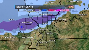
Franklin County is in the quarter to a half inch range. (KFVS-TV Photo)
Here is the quote from Alworth, “We are still studying the threat of freezing rain in the Heartland early Friday. This sort of system is difficult for forecast models to handle. We are expecting a very shallow layer of cold air to blow in from the north Thursday night into Friday morning…with surface air temps across our northern counties just below freezing. Meanwhile just a few hundred feet up we’ll still have warmer air…so that precip will fall as rain and freeze on contact especially on raised surfaces.”
“Models with greater resolution (more layers in the vertical) handle this sort of scenario better…and today we’ll start to get data from these shorter-term models.”
Here is the Hazardous Weather Outlook put out by the National Weather Service of Paducah KY for Franklin County,
.DAY ONE…TODAY AND TONIGHT A FEW ISOLATED THUNDERSTORMS WILL BE POSSIBLE TODAY AND TONIGHT.
.DAYS TWO THROUGH SEVEN…THURSDAY THROUGH TUESDAY ISOLATED THUNDERSTORMS ARE POSSIBLE ON THURSDAY. FREEZING RAIN AND A GLAZE OF ICE ARE POSSIBLE ACROSS PORTIONS OF SOUTHEAST MISSOURI…SOUTHERN ILLINOIS AND SOUTHWEST INDIANA FROM LATE THURSDAY NIGHT THROUGH EARLY FRIDAY EVENING. SIGNIFICANT RAINFALL AMOUNTS COULD OCCUR SATURDAY THROUGH TUESDAY.
HOWEVER…THE EVENT WILL BE SPREAD OUT OVER SEVERAL DAYS. THIS WILL LIKELY RESULT IN STANDING WATER IN LOW LYING AND POOR DRAINAGE AREAS…ALONG WITH POSSIBLE RISES IN SMALL CREEKS AND STREAMS.
Here is a link to the seven day forecast for Franklin County
http://forecast.weather.gov/MapClick.php?map.x=176&map.y=89&site=pah&zmx=1&zmy=1#.WHZePdQrJxA
This is a situation that needs to be taken serious. We have not had the possibility of ice in the forecast like this in several years. I think the “bread and milk” run might be warranted over the next few days.
The B meteorologist student in two whole classes can see anything happening. If we receive half-inch of ice, and we are not going anywhere. Make sure you have adequate supplies to survive without power for several hours.
Franklincountynews-com will keep releasing things from media sources on the Facebook page throughout the day. When any watches are warnings is issued, we will post as a news story.
School-business closings will be updated frequently.


Speak Your Mind
You must be logged in to post a comment.