The fire danger is elevated today because of WNW winds today around 10 mph, dry air (the humidity is currently 47%), and dry
vegetation. The fire danger graphic above and the reasoning was taken from KFVS-12 meteorologist Grant Dade’s Facebook page.
The high today will be in the mid 50’s with lows in the upper 30’s. A cooling trend will start tomorrow, with highs in the mid 40’s and
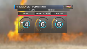
Graphic by KFVS 12 meteorologist Grant Dade
lows in the mid 20’s. Highs Thursday and Friday should be in the mid 30’s.
The snow chance on Saturday will start as rain changing to snow around 4 p.m. It should change to all snow on Saturday night tapering off after midnight. There is a slight chance of rain/snow on Sunday.
It is way to far out to determine how much snow we will receive. At this time there is not ice in the forecast.
We will keep you updated on any changes in the forecast that will take place-sd


Speak Your Mind
You must be logged in to post a comment.