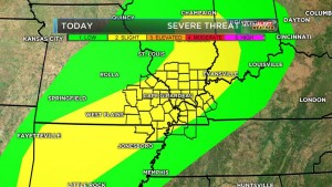
There is a slight risk of severe weather for tonight and tomorrow for the region. Fog will be a problem today until the early afternoon hours. ‘
The high today will be around 60 degrees, rising to near 70 by tomorrow morning. When it gets that warm in early February with an advancing cold front, something has to give.
Large hail and damaging winds will be the biggest threat. Today the National Weather Service in Paducah mentioned the possibility of brief isolated tornadoes.
Here are the statements issued by the NWS regarding the fog and severe weather.
SPECIAL WEATHER STATEMENT
NATIONAL WEATHER SERVICE PADUCAH KY
845 AM CST Mon Feb 6 2017
…AREAS OF DENSE FOG TO PERSIST FOR AWHILE THIS MORNING… FOG WILL CONTINUE TO HAMPER DRIVING CONDITIONS EARLY TODAY OVER MUCH OF THE QUAD STATE REGION. VISIBILITIES WILL BE REDUCED TO LESS THAN A QUARTER MILE WHERE THE FOG IS THICKEST. MOTORISTS SHOULD BE PREPARED FOR VERY LOW VISIBILITIES. SLOW DOWN AND ALLOW SOME EXTRA TIME TO REACH YOUR DESTINATION. USE LOW BEAM HEADLIGHTS WHEN DRIVING IN FOG. CONDITIONS SHOULD SLOWLY IMPROVE AS WE GET INTO THE LATE MORNING AND EARLY AFTERNOON HOURS.
HAZARDOUS WEATHER OUTLOOK
NATIONAL WEATHER SERVICE PADUCAH KY
343 AM CST MON FEB 6 2017
.DAY ONE…TODAY AND TONIGHT THUNDERSTORMS ARE POSSIBLE THIS AFTERNOON AND TONIGHT. A FEW STORMS COULD BECOME SEVERE THIS EVENING AND OVERNIGHT WITH LARGE HAIL BEING THE PRIMARY HAZARD…HOWEVER DAMAGING WINDS AND A BRIEF TORNADO OR TWO ARE NOT OUT OF THE QUESTION.
.DAYS TWO THROUGH SEVEN…TUESDAY THROUGH SUNDAY THUNDERSTORMS WILL BE MORE WIDESPREAD ON TUESDAY. A FEW STORMS COULD BECOME SEVERE ON TUESDAY WITH DAMAGING WINDS BEING THE PRIMARY HAZARD…HOWEVER LARGE HAIL AND A BRIEF TORNADO OR TWO ARE NOT OUT OF THE QUESTION.
Please have some way of getting watches and warnings for this event. We will post all watches on the website. Warnings will be tough to get timely information out on the website. We will give the information on the Facebook page as soon as possible.
sd


Speak Your Mind
You must be logged in to post a comment.