I am going to make a format change to the page. I will only post weather updates when there is a potential hazard on the horizon.
Today it is going to be mostly cloudy with a high in the upper 50’s. There is a chance of thunderstorm over night with a low around 50.
There is a 30% chance of thunderstorms tomorrow afternoon with a high in the lower 70’s.
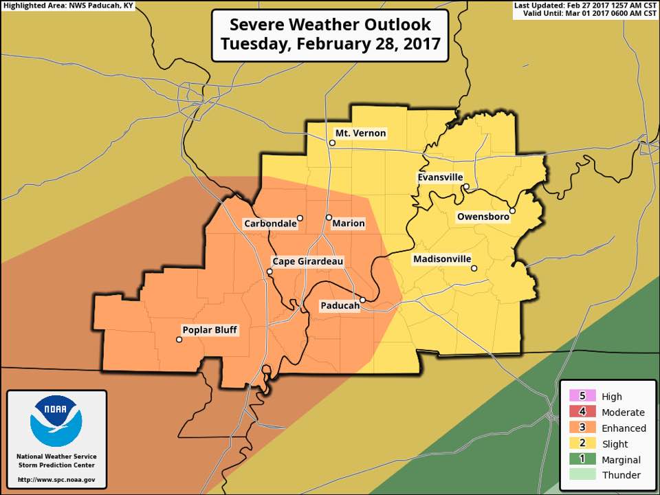
After dark is where things can get interesting. There is an 80 percent chance of thunderstorms. In the graphic, the enhanced risk of severe weather cuts right through Franklin County.
Here is the hazardous weather outlook issued by the National Weather Service in Paducah, KY.
.DAY ONE…Today and Tonight Thunderstorms enter the forecast later tonight, with heavy rain and lightning the primary anticipated storm related hazards. There is a marginal risk of severe storms, mainly for hail, just to our west, and affecting the far western Ozarks in southeast Missouri, late tonight. .
DAYS TWO THROUGH SEVEN…Tuesday through Sunday Thunderstorm chances spike Tuesday and Tuesday night, as we warm sector ahead of an approaching cold front. The increasingly unstable air-mass will be fortified by near record high temperatures in the 70s during the daytime Tuesday. There continues to be an enhanced risk of severe storms for southeast Missouri and adjacent portions of southwest Illinois and far southwest Kentucky, mainly Tuesday afternoon and evening into Tuesday night, with a slight risk of severe storms across the remainder of the area. Damaging winds will be the primary severe weather hazard, but large hail and isolated tornadoes may also be a possibility. Locally heavy rains and frequent lightning will accompany thunderstorms as well. The cold front makes its passage late Tuesday night and early Wednesday morning.
Depending upon its timing, the threat of severe storms may linger into Wednesday morning. As a result, a marginal risk of severe storms lingers south of the Ohio river early Wednesday, with a slight risk of severe storms east of the Lakes in western Kentucky, likewise lingering early Wednesday. Damaging winds will be the primary severe weather hazard, but large hail and isolated tornadoes may also be possible until the front makes its passage in entirety. Locally heavy rains and frequent lightning will accompany thunderstorms as well.
Rick Shanklin Head Meteorologist with the NWS in Paducah made the following statement on his Facebook page. “This bares watching – from late tomorrow into Wednesday morning. Per SPC “…supercells with all hazards possible, including the conditional possibility for a strong tornado(s)..” Stay up to date at weather.gov/PAH or your favorite media source.
As of now, it looks like a 3:00 to 7:00 a.m. time frame Wednesday morning when Franklin County will be under the gun.
Shanklin repeatedly refers to this area as nocturnal tornado alley. We have our strongest and deadliest tornadoes in the overnight hours.
I will be up as long as I have to tomorrow night the radar and will start passing along warnings if Franklin County is in the path of a storm 100 miles out. I will be in contact with Franklin County Emergency Management agency if any information needs passed along as well.
Showers will linger around for Wednesday. Thursday and Friday will be seasonal, with highs in the lower 50’s. The early spring will return for the weekend with highs back up in the 60’s.-sd


Speak Your Mind
You must be logged in to post a comment.