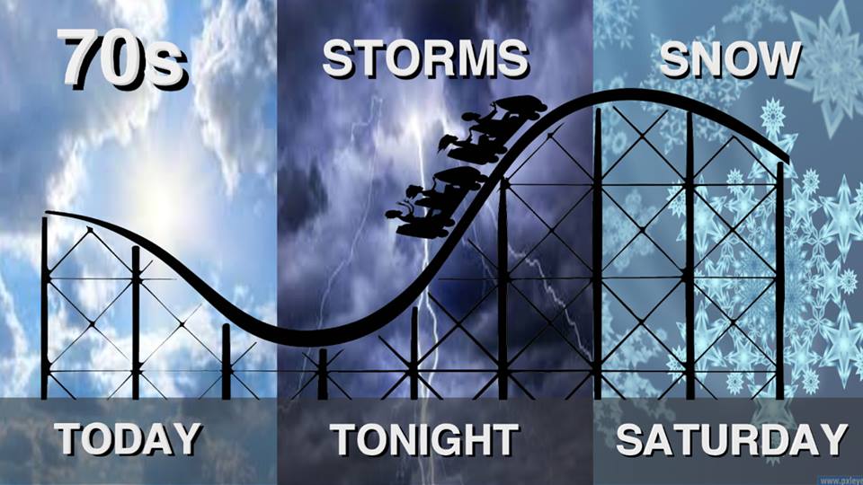
Our run of an early spring is about to come to a close. It will be sunny with highs in the mid 70’s today.
Tonight there is a 60% chance of showers and thunderstorms with a low in the mid 30’s. There is a marginal risk of severe weather for Franklin County tonight.
Tomorrow will be sunny with the high in the mid 40’s.
Here is were things get interesting. Friday night there is a small chance of snow. It will continue all day Saturday ending Saturday night.
KFVS TV Laura Wibbermeyer said 1″ to 3″ inches for all the Channel 12 viewing area. I have looked at a few models and most of them are consistent with 2″ to 4″ inches here in Franklin County.
Here is a couple statements issued by the National Weather Service in Paducah regarding the hodgepodge of weather we are slated to experience.
SPECIAL WEATHER STATEMENT
…Light Snows Possible Saturday Into Saturday Evening… Arctic air will surge through the area late tonight through Friday. Meanwhile, an upper level disturbance will drop southeastward into the region, bringing a good chance of some light snow to much of the region Saturday into Saturday evening. If temperatures can warm into the middle or upper 30s the snow may mix with or change to rain over portions of the region in the afternoon. Relatively warm ground and road conditions along with temperatures hovering around or just above freezing should minimize travel impacts through the day. However, if the snow comes down hard at times, or if snow lasts much past sunset when temperatures fall into the 20s for good, there could be some impacts, especially on elevated roadways. All precipitation should exit the region by midnight.
HAZARDOUS WEATHER OUTLOOK
.DAY ONE…Today and Tonight A good chance of thunderstorms is forecast across the region late this afternoon and primarily this evening. A few of these storms could reach severe levels over the southwestern half of our region, with the emphasis on southeast Missouri and the Purchase Area of Kentucky. Large hail will be the primary concern for individual storms, but if they develop into a line or clusters, damaging winds will become the primary concern.
.DAYS TWO THROUGH SEVEN…Friday through Wednesday Some snowfall will be possible Saturday into Saturday evening. Relatively warm antecedent surface conditions would likely limit overall impacts, especially during the daylight hours. However, conditions could deteriorate some if snow were to last much past sunset and temperatures fall into the 20s.
FREEZE WARNING
The National Weather Service in Paducah has issued a Freeze Warning, which is in effect from 10 PM Friday to 8 AM CST Saturday. * TEMPERATURE…Mid 20s along the I-64 corridor to around 30 near the border region of southeast Missouri. * IMPACTS…The forecast temperatures will likely damage fruit trees, especially those trees that have already budded out such as peach trees. Other plants that are similarly ahead of schedule for the spring growing season could also be impacted. Please take precautions to protect any sensitive plants. The cold nights will likely continue well into next week. PRECAUTIONARY/PREPAREDNESS ACTIONS… A Freeze Warning means sub-freezing temperatures are imminent or highly likely. These conditions will kill crops and other sensitive vegetation.
As always we will keep you updated on franklincounty-news.com for all the latest weather information tonight for severe weatehr and the possible wintry precipitation events for Saturday and Monday. We will also share any cancellations.


Speak Your Mind
You must be logged in to post a comment.