by Steve Dunford
First of all I would like to give a shout out to my son Andrew Dunford, who six years ago today as a twelve year old, started a Facebook page called Twister Weather. He has quite the following. Friday through Sunday are the days that he lives for. He does a lot of work for Franklin County Emergency Management Agency during severe weather events. I encourage you to follow his page.
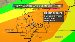
KFVS FIRST ALERT ACTION DAY FOR FRIDAY I’m getting more concerned with our severe weather threat Friday evening into the overnight hours. Large hail, damaging winds and tornadoes are all possible. Many of these storms will move in after sunset. Some of you could be sleeping! Please SHARE to keep your friends safe. It’s always a good idea to have a couple ways to get warnings. The KFVS Weather App is great way to get those alerts and I also recommend a weather radio!! (KFVS TV Meteorologist Laura Wibbenmeyer)
Lets deal with one thing at a time. First the severe threat for tomorrow. The Storm Prediction Center has all of Southern Illinois placed under an enhanced risk of severe weather. The model the SPC has put out today places us under a 30% risk of severe weather with hatch marks, which means there is that probability of seeing a significant severe event 25 miles from your location. Please view the caption to the left and read what Laura Wibbenmeyer, KFVS-TV meteorologist had to say about the situation.
Dr. Greg Forbes of the Weather Channel has the TORCON index for Southern Illinois as a three, which is consistent with the SPC.
As far as the severe threat for the rest of the weekend, on Saturday, the borderline between a slight risk and a marginal risk for severe weather. The slight-marginal line cuts through the heart of Southern Illinois and Franklin County.
On Sunday the Southern Seven counties are in an area outlined for severe weather. This will not be given a category until tomorrow.
Starting Friday night through the weekend, there is a Flash Flood Watch issued for All Of Southern Illinois. Here is the information on the watch from the National Weather Service of Paducah, KY
…MULTIPLE ROUNDS OF SHOWERS AND THUNDERSTORMS EXPECTED FRIDAY NIGHT THROUGH SUNDAY NIGHT…
…FLASH FLOOD WATCH IN EFFECT FROM FRIDAY EVENING THROUGH LATE SUNDAY NIGHT… The National Weather Service in Paducah has issued a * Flash Flood Watch for portions of southern Illinois, western Kentucky, and southeast Missouri, including the following areas, in southern Illinois, Alexander, Edwards, Franklin, Gallatin, Hamilton, Hardin, Jackson, Jefferson, Johnson, Massac, Perry IL, Pope, Pulaski, Saline, Union, Wabash, Wayne IL, White, and Williamson. In western Kentucky, Ballard, Carlisle, Fulton, Hickman, and McCracken. In southeast Missouri, Bollinger, Butler, Cape Girardeau, Carter, Mississippi, New Madrid, Perry MO, Ripley, Scott, Stoddard, and Wayne MO. *
From Friday evening through late Sunday night * The watch is generally in effect for locations along and west of a line extending from near Fulton, Kentucky to Mount Carmel, Illinois, including all of southeast Missouri. Much of this region has already received 1.5 to 3 inches of rainfall in the past 12 to 18 hours. Though things may tend to dry out a bit today and Friday, numerous thunderstorms with very heavy rain are expected to develop Friday night and then again Saturday night, Sunday and Sunday evening. There may be a break in the heavy rain threat during the day Saturday over western Kentucky, southwest Indiana, far southeast Missouri and the southern tip of Illinois. Several inches of rain are expected before all is said and done late Sunday night. The highest amounts are expected to fall from southeast Missouri into southwest Illinois. * In addition to the possibility of flash flooding, the heavy rainfall is expected to cause rises on many of the area rivers, particularly the smaller rivers in southeast Missouri such as the Saint Francis, Black, and Current.
PRECAUTIONARY/PREPAREDNESS ACTIONS… A Flash Flood Watch means that conditions may develop that lead to flash flooding. Flash flooding is a very dangerous situation. You should monitor later forecasts and be prepared to take action should Flash Flood Warnings be issued.


Speak Your Mind
You must be logged in to post a comment.