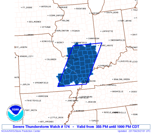
 URGENT – IMMEDIATE BROADCAST REQUESTED Severe Thunderstorm Watch Number 174 NWS Storm Prediction Center Norman OK 355 PM CDT Sat Apr 29 2017
The NWS Storm Prediction Center has issued a * Severe Thunderstorm Watch for portions of Southern Illinois Extreme Western Kentucky Southeast Missouri * Effective this Saturday afternoon and evening from 355 PM until 1000 PM CDT. * Primary threats include… Scattered damaging wind gusts to 70 mph possible Scattered large hail events to 1.5 inches in diameter possible A tornado or two possible
SUMMARY…A line of storms is bowing eastward across east-central and southeast Missouri toward southern Illinois. It will pose a threat for damaging wind and possible hail as moves along and south of a warm front through the later afternoon and evening. The severe thunderstorm watch area is approximately along and 70 statute miles east and west of a line from 10 miles north of Mattoon IL to 35 miles southwest of Cape Girardeau MO.
PRECAUTIONARY/PREPAREDNESS ACTIONS… REMEMBER…A Severe Thunderstorm Watch means conditions are favorable for severe thunderstorms in and close to the watch area. Persons in these areas should be on the lookout for threatening weather conditions and listen for later statements and possible warnings. Severe thunderstorms can and occasionally do produce tornadoes.


Speak Your Mind
You must be logged in to post a comment.