by Steve Dunford

The Flood Warning for Franklin County has been extended until 5:45 this evening. The warning text will be included in the bottom of this post. There are several road closures in the county still. This has been posted on the website and the Facebook page.
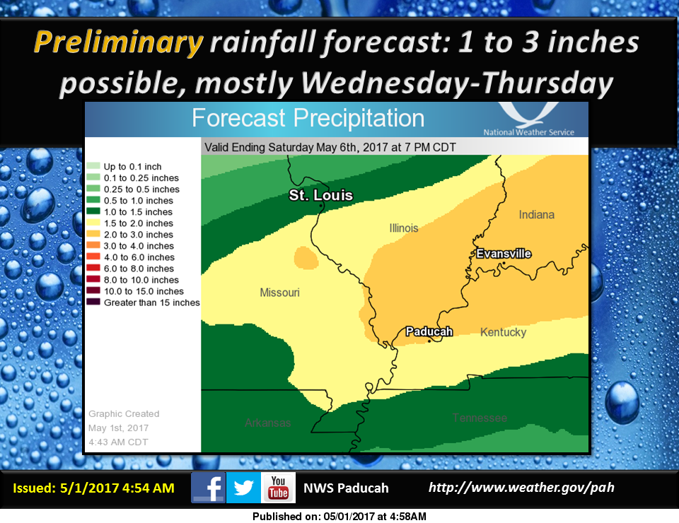
Starting Tuesday night into the overnight hours on Friday Morning there are chances of rain. During this period, it is forecast that we will receive an additional 1-3 inches of rainfall. (see graphic above)

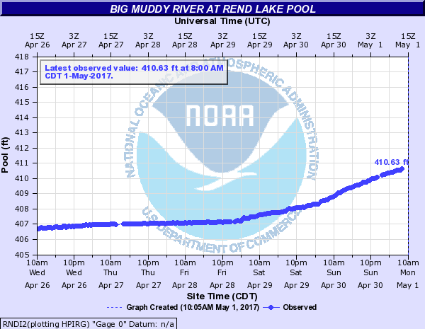
The water at Rend Lake is clearing the entire spillway, and not just the notch in the middle. (see graphic above) The water will do this at 410 feet. There is also a Lake Wind advisory for all of Southern Illinois. (advisory text below)
I will provide an update on facility closures. South Sandusky boat ramp is schedued to close sometime this evening.

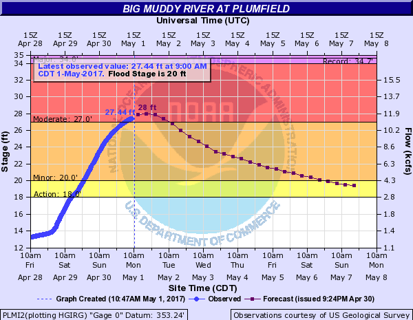
The Big Muddy at Plumfield is set to crest today at 28 feet in the moderate flood stage range. I spoke with Mary Lamm, Project Hydrologist at the National Weather Service in Paducah KY, and asked about the Big Muddy River and if the water released from Rend Lake will read on the automatic gauge there.
In our conversation she said that the gauge does compensate for it. She said that Rend Lake will affect the recession of the water that far down stream, but not add to the rise of it. River stage forecasts will include the additional rainfall projected starting tomorrow.
In some regional stages the Mississippi will crest in Chester at 43.5 feet on Thursday, which puts it in major flood stage. Several media outlets are sharing concern that the bridge will be closed there. There is only one lane open on the Missouri side. At Cape Girardeau the river will crest at 48.5 feet one-tenth above the record. It will also crest in Thebes on Saturday at 47 feet a few tenths below the record. All points on the Ohio, including Cairo are in moderate flood stage.
Here are the warnings and statements issued by the National Weather Service in Paducah KY.
FLOOD WARNING
The National Weather Service in Paducah has issued a * Flood Warning for… Perry County in south central Illinois… White County in southeastern Illinois… Wayne County in south central Illinois… Wabash County in southeastern Illinois… Jefferson County in south central Illinois… Edwards County in southeastern Illinois… Williamson County in southern Illinois… Saline County in southern Illinois… Jackson County in southern Illinois… Franklin County in south central Illinois… Hamilton County in south central Illinois… * Until 545 PM CDT Monday *
At 544 AM CDT, flooding continued in many areas. The threat for heavy rainfall is over. However, flooding along rivers, creeks and streams will continue, along with numerous water covered, flooded roads. There should be improvement in some areas. * Some locations that will experience flooding include… Carbondale, Marion, Mount Vernon, Herrin, Harrisburg, West Frankfort, Murphysboro, Mount Carmel, Benton, Du Quoin, Pinckneyville, Carterville, Carmi, Fairfield, Eldorado, Johnston City, McLeansboro, Christopher, Albion and Rend Lake Area.
PRECAUTIONARY/PREPAREDNESS ACTIONS… Turn around, don`t drown when encountering flooded roads. Most flood deaths occur in vehicles. Excessive runoff from heavy rainfall will cause flooding of small creeks and streams, country roads, farmland, and other low lying spots.
FLOOD WARNING FOR THE BIG MUDDY
…The flood warning continues for the following rivers in Illinois… Big Muddy River near Plumfield and Murphysboro .
The Big Muddy river at Plumfield is expected to crest this evening at 28.0 feet. It will start falling after that and should fall below flood stage on Saturday morning.
On the Big Muddy at Murphysboro… heavy rainfall…combined with backwater from the Misssissippi River… will continue to cause a rise this week. It will crest at 40 feet on Thursday…which puts us in the major flood category.
PRECAUTIONARY/PREPAREDNESS ACTIONS… SAFETY MESSAGE… Never drive cars…trucks or sport utility vehicles through flooded areas. The water may be too deep to allow safe passage. Never allow children to play in or near flood waters. Stay tuned to NOAA Weather Radio or your local media for further statements and possible updated forecasts.
HAZARDOUS WEATHER OUTLOOK
This Hazardous Weather Outlook is for portions of southern Illinois, southwest Indiana, western Kentucky, and southeast Missouri. .
DAY ONE…Today and Tonight Following the weekend heavy rainfall, flooding continues in parts of our region, mainly southeast Missouri and southern Illinois. Major to record flooding exists on smaller rivers in southeast Missouri and southern Illinois. Please check the latest flood statements and warnings for details. Gusty southwest winds from 15 to 25 mph are expected today, with gusts up to 35 mph this afternoon. A Lake Wind Advisory is in effect for today.
.DAYS TWO THROUGH SEVEN…Tuesday through Sunday River flooding will continue through next weekend. Some of the larger mainstream rivers such as the Mississippi River will rise throughout the week. Some of the smaller rivers will begin to recede Tuesday. Please check river flood statements. A chance of thunderstorms is forecast for all or a portion of the area Wednesday and Thursday. Lightning and locally heavy rainfall will be the primary concerns. Rainfall well over an inch from Wednesday through Thursday may aggravate existing flooding or lead to new flooding, especially over southern Illinois and southwest Indiana.
LAKE WIND ADVISORY
.Strong gusty southwest winds are expected today. These winds will be associated with the low pressure system that brought heavy rain and flooding to our region over the weekend.
The National Weather Service in Paducah has issued a Lake Wind Advisory, which is in effect from 7 AM this morning to 8 PM CDT this evening.
* TIMING…The strongest winds will occur from the late morning through the afternoon hours.
* WINDS…Southwest winds will increase to around 15 mph by mid- morning, then 20 to 25 mph for a few hours this afternoon. Gusts from 30 to 35 mph are likely this afternoon. Winds will decrease around sunset.
* IMPACTS…The strong gusty winds will pose a hazard to small boat operators on area lakes and rivers. Flood recovery efforts will also be negatively impacted, especially where boats are needed for checking flooded property.
PRECAUTIONARY/PREPAREDNESS ACTIONS… A Lake Wind Advisory indicates that winds will cause rough chop on area lakes. Small boats will be especially prone to capsizing.


Speak Your Mind
You must be logged in to post a comment.