by Steve Dunford
The National Weather service issued a special weather statement in regards to the heat this afternoon. Heat indexes are to be between 100-105.
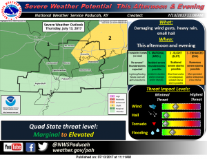 There is a marginal risk (level one of five) for severe weather for this afternoon into the overnight hours for Franklin County and most of Southern Illinois. As you can see from the graphic to the left, There are a few counties in Southern Illinois that are on the edge of a slight risk (level 2 of severe weather).
The Storm Prediction Center is in discussions of changing the term slight risk to an elevated risk. Some meteorologists in this market already use that term.
This is what I expect. The cloud cover should be lifting at any time. In the late afternoon hours, you could see one or two pop up storms that could turn severe.
This is in advance of an approaching cold front. There should be a line of storms that will move through the area from northwest to southeast. The best time for them to reach Franklin County is between 10 and 11 p.m. There is the possibility of one or two severe thunderstorm warnings being issued during this time.
The main threat is damaging winds, with large hail being secondary. The tornado threat is near zero.
Please follow the website and especially the Facebook page for any watches or warnings. Below is the Special Weather Statement involving the heat and the hazardous weather outlook. At the end is the seven day forecast, which I will post daily from this point on. The forecast will pinpoint on Franklin County.
If you are going north or west toward the St. Louis Metro area, there is a heat advisory for heat indices running from 105-110
SPECIAL WEATHER STATEMENT
NATIONAL WEATHER SERVICE PADUCAH KY
…Heat Index Values of 100 to 105 degrees expected today over
most of the area…
Another afternoon of oppressive heat and humidity can be expected
today, leading to heat index values between 100 and 105 degrees.
The highest heat index values will be over southeast Missouri and
southern Illinois where isolated location may briefly reach 105.
Values of 100 to 102 are possible over southwest Indiana and west
Kentucky.
A few showers and thunderstorms are expected today, especially
near I-64, which will help keep the heat down at a few locations.
Be watchful for those especially impacted by the heat. Young
children, the elderly, persons with serious health issues, and
pets are especially susceptible to the heat during this time of
year.
Do not leave young children or pets in cars with closed
windows…this could become deadly situation in a short period of
time.
Be sure to drink plenty of water, take frequent rest breaks in the
shade or air conditioned shelter. Get out of the heat, if you are
experiencing health issues.
Hazardous Weather Outlook
National Weather Service Paducah KY
.DAY ONE…Today and Tonight
There is a slight risk of severe thunderstorms this afternoon and
evening generally north of Interstate 64 in southern Illinois and
southwest Indiana. There is a marginal risk north of a line from
Cape Girardeau Missouri to near Owensboro Kentucky. Damage wind
gusts and locally heavy rainfall will be the main hazards.
Heat and humidity will push heat index values into the 100 to 105
range across much of the area this afternoon.
.DAYS TWO THROUGH SEVEN…Friday through Wednesday
There is a marginal risk of severe thunderstorms Friday afternoon
and evening across much of the area. Damaging wind gust and
locally heavy rainfall will be the main hazards.
A few thunderstorms are possible Sunday afternoon and evening.
Severe storms are not expected during that time.
Heat index values will reach the 100 to 105 range during Tuesday
and Wednesday afternoons, mainly over southeast Missouri and
adjacent areas of southern Illinois and west Kentucky.
.SPOTTER INFORMATION STATEMENT…
Spotter activation may be necessary this afternoon and evening.
Detailed Forecast


Speak Your Mind
You must be logged in to post a comment.