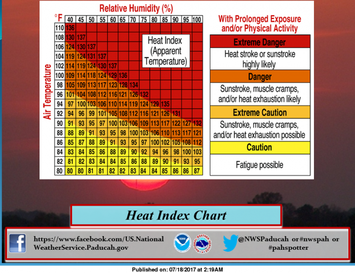
This may come in handy this week. It is important to understand that this chart is not for those who are out working or physically active in the full sun. The heat index chart takes the air temperature, shown on the column on the right side of the image, and the relative humidity, shown along the row on the top of the image to determine heat index values. As an example, we will use an air temperature of 92 degrees and a relative humidity value of 50%. To find the heat index value for the air temperature and relative humidity, look for the relative humidity value of 50% at the top of the chart. Go down the column until you reach the row corresponding to the air temperature of 92 degrees. The value inside of that square is 99 degrees. That is the expected heat index for the given air temperature and relative humidity. The Darker shading on the chart corresponds to the health impact of prolonged exposure and/or physical activity under those weather conditions. Dangerous and even deadly consequences can occur if you stay out too long in the summer heat, without taking precautions. Keep a watch on children, persons with serious health conditions, and pets during the summer heat. (NWS Paducah)
Hazardous Weather Outlook
National Weather Service Paducah KY
357 AM CDT Tue Jul 18 2017
.DAY ONE…Today and Tonight
Widely scattered thunderstorms are possible, with lightning,
locally heavy rain, and gusty winds the primary hazards.
The heat index will reach near 100 this afternoon.
.DAYS TWO THROUGH SEVEN…Wednesday through Monday
An Excessive Heat Watch is in effect for Wednesday through Sunday.
Refer to the Watch product for details.
.SPOTTER INFORMATION STATEMENT…
Spotter activation is not expected.
URGENT – WEATHER MESSAGE
National Weather Service Paducah KY
224 AM CDT Tue Jul 18 2017
…Conditions setting up for Dangerous Heat Wave Wednesday
through Sunday…
.As high pressure exerts increasing control over the mid
Mississippi river valley this week, expect a corresponding rise
in temperatures and humidity to dangerously high levels for our
area. Heat indices nudging to the triple digits will start to
show up today, and increase and become more commonplace in the 100
to 105 range through the remainder of the week and into the
weekend, offering our first prolonged duration heat event of the
summer.
…EXCESSIVE HEAT WATCH REMAINS IN EFFECT FROM WEDNESDAY
AFTERNOON THROUGH SUNDAY EVENING…
* TIMING…Wednesday afternoon through Sunday evening.
* HEAT INDEX VALUES…peaking near 105 degrees each afternoon.
* IMPACTS…The combination of hot temperatures and high
humidity will lead to an increased risk of heat related stress
and illness. The very young, the elderly, those without air
conditioning, and those participating in strenuous outdoor
activities will be the most susceptible. Also, car interiors
will reach lethal temperatures in a matter of minutes.
PRECAUTIONARY/PREPAREDNESS ACTIONS…
An Excessive Heat Watch means that a prolonged period of hot
temperatures is expected. The combination of hot temperatures and
high humidity will combine to create a dangerous situation in
which heat illnesses are possible. Drink plenty of fluids, stay
in an air conditioned room, stay out of the sun ,and check up on
relatives and neighbors.
Detailed Forecast


Speak Your Mind
You must be logged in to post a comment.