by Steve Dunford
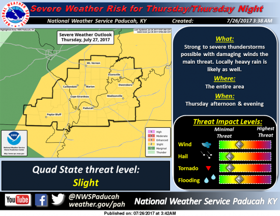
Severe weather threat for Thursday/Thursday Night: A cold front will move south toward the area on Thursday and move south of the area by Friday. This front will provide a focus for showers and thunderstorms on Thursday into Thursday night. Some of these storms may bring damaging winds. (NWS, Paducah KY)
The heat advisory that was issued yesterday afternoon has been scaled down to the counties along and west of the I -57 corridor. (Jefferson, Franklin, Williamson counties are included and points westward.)
Today will be a repeat of the days like we had all last week. After a stormy day tomorrow, we have a pleasant and an outstanding weekend on tap, with highs in the lower 80’s.
For tomorrow afternoon into tomorrow evening, I will be keeping a close eye on the radar. My main focus will be Franklin County, but warnings will be passed along from the bordering counties as well. During a severe weather event, I will post things on the Facebook page only.
Below is the latest statement on the Heat Advisory, then the Hazardous Weather Outlook, and the end is an awesome seven day forecast.
URGENT – WEATHER MESSAGE
National Weather Service Paducah KY
…Hazardous heat indices expected today…
.A southwest wind flow of hot and very humid air will occur across
the area today.
…HEAT ADVISORY REMAINS IN EFFECT FROM NOON TODAY TO 8 PM CDT
THIS EVENING…
* TEMPERATURE…High temperatures will be mostly in the mid 90s.
The peak heat index in the afternoon will generally be around
105 degrees.
* IMPACTS…Persons who work or spend time outdoors will be at a
potential risk for heat-related illness. Heat exhaustion or
heat stroke may occur if precautions are not taken. The very
young, the elderly, and those without air conditioning are
especially susceptible to heat related health problems.
PRECAUTIONARY/PREPAREDNESS ACTIONS…
A Heat Advisory means that a period of hot temperatures is
expected. The combination of hot temperatures and high humidity
will combine to create a situation in which heat illnesses are
possible. Drink plenty of fluids…stay in an air-conditioned
room…stay out of the sun…and check up on relatives and
neighbors.
To reduce risk during outdoor work…the occupational safety and
health administration recommends scheduling frequent rest breaks
in shaded or air conditioned environments. Anyone overcome by
heat should be moved to a cool and shaded location. Heat stroke
is an emergency…call 9 1 1.
Hazardous Weather Outlook
National Weather Service Paducah KY
310 AM CDT Wed Jul 26 2017
This Hazardous Weather Outlook is for portions of southern
Illinois, southwest Indiana, western Kentucky, and southeast
Missouri.
.DAY ONE…Today and Tonight
Heat Advisory today west of a line from Mount Vernon, Illinois to
Paducah, Kentucky.
There is a slight chance of thunderstorms today, best chances east
of the Mississippi River. Tonight, the small chance of storms
shifts north toward the Interstate 64 corridor, extending as far
south as perhaps Route 13 in southern Illinois, east to about
Owensboro, Kentucky.
.DAYS TWO THROUGH SEVEN…Thursday through Tuesday
For the entire four state area, a few strong to severe
thunderstorms cannot be ruled out Thursday afternoon and night.
Damaging wind gusts will be the main hazard. Locally heavy rain is
possible as well.
.SPOTTER INFORMATION STATEMENT…
Spotter activation may be requested Thursday afternoon and night.
Detailed Forecast


Speak Your Mind
You must be logged in to post a comment.