By Steve Dunford
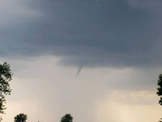
Funnel Cloud that was south of Ina yesterday afternoon. (photo from Jason Crawford’s Facebook page)
This was a weak funnel cloud that was around Rend Lake College yesterday afternoon. First of all, I do not want anyone to panic. I am not implying there is a tornado threat. I answered a few questions about this yesterday.
I was asked if there was any threat of this touching down. It was very minimal. If it did, it would have been a weak F-0. It would have broke some small limbs, blew trash cans and lawn furniture around, and might have blown an unanchored trampoline into a tree.
Right above it is a very small wall cloud. If this was a stronger funnel, you could tell the rotation from the naked eye. There was not enough rotation on radar, or the storm spotters that was on the storm to prompt a Tornado Warning for Southern Jefferson, or even Northern Franklin County.
Let me remind you that I am not a meteorologist. I took some meteorology courses at SIU as electives, I am an Elite Storm Spotter with the National Weather Service, and have taken several weather seminars.
Also from yesterday’s storm, there was some wind damage reported south of Johnston City, and pea size hail in the Carbondale area.
For today, we could see some pop up storms, just like yesterday afternoon. In the Hazardous Weather Outlook, the National Weather Service of Paducah KY, has stated that some storms could pulse up to near severe levels. However, the Storm Prediction Center, has taken us out of the marginal level for severe weather. I could see the possibility of that changing.
Tonight there will be showers and thunderstorms forming in front of an advancing cold front. The storms will move from a northwest to southeasterly direction. The storms have been moving this way for a month now. Just off of observation, I believe we could be in for an early fall.
After the front passes, Friday and Saturday will be perfect, with highs around 80 degrees. There are chances of showers and thunderstorms on Sunday and Wednesday. At this time, nothing severe.
Here is the Hazardous Weather Outlook and the seven day forecast below.
Hazardous Weather Outlook
National Weather Service Paducah KY
323 AM CDT Thu Aug 3 2017
.DAY ONE…Today and Tonight
Widely scattered thunderstorms are expected throughout the region
this afternoon. A few storms may pulse up and produce near severe
level hail and wind gusts, but the primary concerns will be
locally heavy rainfall and lightning.
As a cold front approaches tonight, scattered to numerous
thunderstorms are expected to move southeast into the region
around midnight and then to near the Ohio River by daybreak.
Locally heavy rainfall and lightning will be the primary concerns.
.DAYS TWO THROUGH SEVEN…Friday through Wednesday
Scattered to numerous thunderstorms are expected to move through
west Kentucky Friday morning. Locally heavy rainfall and lightning
will be the primary concerns.
A chance of thunderstorms is forecast late Saturday night through
Tuesday, mainly across western Kentucky, southeast Missouri, and
extreme southern Illinois. The chance of storms will expand across
the rest of the region Wednesday. The main hazards with any
storms will be locally heavy rain and dangerous lightning.


Speak Your Mind
You must be logged in to post a comment.