The Weather Channel is calling for morning thunderstorms then clearing for the day of the eclipse, with a high of 83 degrees. The storm prediction center has placed points north of Route 13 under a marginal risk of severe weather today.
Hazardous Weather Outlook
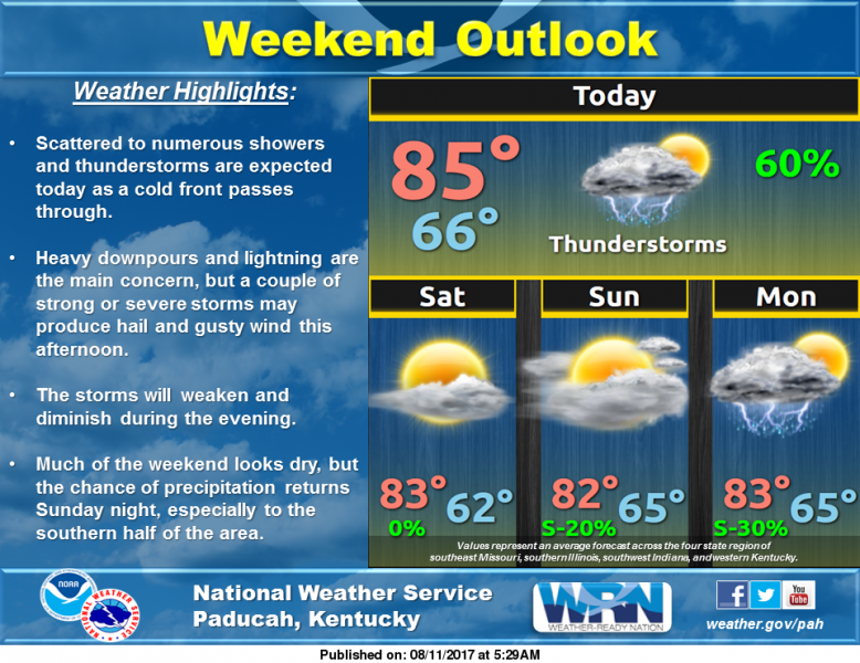
National Weather Service Paducah KY
443 AM CDT Fri Aug 11 2017
This Hazardous Weather Outlook is for portions of southern
Illinois, southwest Indiana, western Kentucky, and southeast
Missouri.
.DAY ONE…Today and Tonight
Scattered to numerous thunderstorms are expected today as a cold
front moves through. While lightning and locally heavy downpours
will be the primary concern, a couple of strong or severe storms
may produce hail and gusty wind, mainly this afternoon. The storms
will weaken and diminish during the evening.
.DAYS TWO THROUGH SEVEN…Saturday through Thursday
Periodic chances for thunderstorms will be possible next week,
especially over southern sections of the outlook area through
Wednesday. Although the probability of widespread severe weather
remains low, a few storms may produce torrential downpours and
isolated strong wind gusts, mainly during the afternoon and early
evening hours.
.SPOTTER INFORMATION STATEMENT…
Spotter activation is not anticipated.
Detailed Forecast
weather.gov
Today
A 50 percent chance of showers and thunderstorms. Mostly cloudy, with a high near 83. Calm wind becoming west around 6 mph in the morning.
Tonight
A 20 percent chance of showers and thunderstorms before 11pm. Partly cloudy, with a low around 64. Light north wind.
Saturday
Mostly sunny, with a high near 82. North wind around 6 mph.
Saturday Night
Partly cloudy, with a low around 61. Northeast wind 3 to 5 mph.
Sunday
Partly sunny, with a high near 81. East wind 3 to 6 mph.
Sunday Night
Mostly cloudy, with a low around 64. Light east northeast wind.
Monday
Partly sunny, with a high near 82. East northeast wind 3 to 5 mph.
Monday Night
A slight chance of showers and thunderstorms before 1am. Mostly cloudy, with a low around 64. Northeast wind 3 to 5 mph.
Tuesday
Mostly sunny, with a high near 83. Northeast wind 3 to 6 mph.
Tuesday Night
Mostly clear, with a low around 64. East northeast wind around 5 mph becoming calm in the evening.
Wednesday
A slight chance of showers and thunderstorms. Mostly sunny, with a high near 85. South southeast wind 3 to 6 mph.
Wednesday Night
A chance of showers and thunderstorms. Partly cloudy, with a low around 66. South wind 3 to 5 mph.
Thursday
A chance of showers and thunderstorms. Partly sunny, with a high near 86. Southwest wind around 6 mph.


Speak Your Mind
You must be logged in to post a comment.