When the fog burns off, sunny with highs in the mid 80’s
Eclipse forecast information after the advisory
URGENT – WEATHER MESSAGE
National Weather Service Paducah KY
…DENSE FOG ADVISORY IN EFFECT UNTIL 9 AM CDT THIS MORNING…
The National Weather Service in Paducah has issued a Dense Fog
Advisory, which is in effect until 9 AM CDT this morning which is in effect for the following counties in Southern Illinois: Jackson, Union, Alexander, Pulaski and Massac.
* VISIBILITY…At or below one quarter of a mile.
* IMPACTS…Hazardous driving conditions through the early morning
hours.
PRECAUTIONARY/PREPAREDNESS ACTIONS…
A Dense Fog Advisory means visibilities will frequently be
reduced to less than one quarter mile. If driving…slow down…
use your headlights…and leave plenty of distance ahead of you.
The forecast for the eclipse is Sunny with a high of 90. Below is a graphic from the National Weather Service explaining the forecast terms for cloud cover.
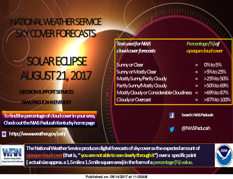
When you find the sky cover for your location from the NWS Paducah Kentucky home page, you can determine what the amount of cloud cover, in percentage (%), means to you. As an example, 55 % opaque cloud cover means \”partly sunny\” conditions at your location for that hour. (NWS Paudcah)
Hazardous Weather Outlook
National Weather Service Paducah KY
.DAY ONE…Today and Tonight
Patchy dense fog will be across portions of southeast Missouri,
southern Illinois, and far west Kentucky early this morning.
There is a chance of thunderstorms today from southeast Missouri
into west Kentucky, with the chance extending into southern
Illinois by tonight.
.DAYS TWO THROUGH SEVEN…Wednesday through Monday
There is a chance of thunderstorms Wednesday through Thursday
evening. A few strong storms cannot be ruled out. There is
another chance for thunderstorms Saturday.
Heat index values will peak near 100 degrees during the afternoon
hours both Wednesday and Thursday.
.SPOTTER INFORMATION STATEMENT…
Spotter activation is not anticipated.
Seven Day Forecast
Today
Areas of fog before 10am. Otherwise, partly sunny, with a high near 86. Calm wind becoming south southwest around 5 mph in the afternoon.
Tonight
A 20 percent chance of showers after 2am. Partly cloudy, with a low around 71. Calm wind becoming east southeast around 5 mph after midnight.
Wednesday
A slight chance of showers, then a chance of showers and thunderstorms after 8am. Partly sunny, with a high near 88. South wind 3 to 7 mph. Chance of precipitation is 30%.
Wednesday Night
A 40 percent chance of showers and thunderstorms. Mostly cloudy, with a low around 75. South wind around 6 mph.
Thursday
A 50 percent chance of showers and thunderstorms. Mostly cloudy, with a high near 90. Southwest wind 6 to 10 mph.
Thursday Night
A 50 percent chance of showers and thunderstorms, mainly before 8pm. Partly cloudy, with a low around 68. West wind 3 to 8 mph.
Friday
Mostly sunny, with a high near 86. West northwest wind 5 to 7 mph.
Friday Night
Partly cloudy, with a low around 67. North northwest wind around 5 mph becoming calm in the evening.
Saturday
A slight chance of showers and thunderstorms after 2pm. Mostly sunny, with a high near 87. Light southeast wind.
Saturday Night
A slight chance of showers and thunderstorms before 2am. Partly cloudy, with a low around 67. Light east southeast wind.
Sunday
Sunny, with a high near 89. Light east southeast wind.
Sunday Night
Mostly clear, with a low around 68. Light east southeast wind.
Monday
Mostly sunny, with a high near 90. Southeast wind 3 to 5 mph.


Speak Your Mind
You must be logged in to post a comment.