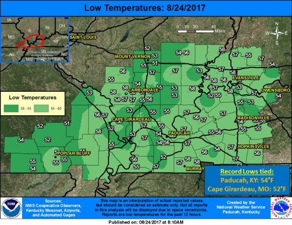
The calendar may say August still, but it felt more like Fall this morning! Temperatures in the 50s greeted the region this morning, which made it feel more like late September than late August. Record lows were tied in Paducah, KY and Cape Girardeau, MO of 54 and 52 degrees respectively. This was the coolest temperature recorded in Paducah since June 8th (also 54 degrees). NWS Paducah
Seven day forecast
Today
Sunny, with a high near 81. Calm wind becoming north northeast around 6 mph in the afternoon.
Tonight
Mostly clear, with a low around 57. East northeast wind 3 to 5 mph.
Friday
Mostly sunny, with a high near 80. East wind around 6 mph.
Friday Night
Partly cloudy, with a low around 58. East northeast wind 3 to 5 mph.
Saturday
Mostly sunny, with a high near 81. East wind 3 to 7 mph.
Saturday Night
Partly cloudy, with a low around 59. East northeast wind around 5 mph becoming calm after midnight.
Sunday
Mostly sunny, with a high near 84. Calm wind becoming southeast around 5 mph in the afternoon.
Sunday Night
Mostly cloudy, with a low around 63. East wind around 5 mph becoming calm in the evening.
Monday
A chance of showers and thunderstorms, mainly after 1pm. Mostly cloudy, with a high near 81. Light and variable wind.
Monday Night
A chance of showers and thunderstorms, mainly before 1am. Mostly cloudy, with a low around 63. Light north northeast wind.
Tuesday
A chance of showers and thunderstorms. Partly sunny, with a high near 80. Northwest wind 3 to 6 mph.
Tuesday Night
Partly cloudy, with a low around 62. North northeast wind around 5 mph becoming calm in the evening.
Wednesday
A slight chance of showers. Mostly sunny, with a high near 81. Calm wind becoming north northwest around 5 mph in the afternoon.


Speak Your Mind
You must be logged in to post a comment.