Remnants of Tropical Storm Harvey on its way
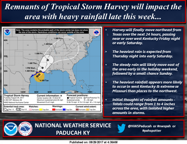
The remnants of Tropical Storm Harvey will be reaching the area Thursday night. It should exit the area on Sunday morning. There is a chance of heavy rain and could influence high school football.
At this time, nothing severe is in the forecast. There could be some heavy rain and moderate wind with this. I will keep you posted as the system gets closer. – Steve
Special Weather Statement
…PATCHY DENSE FOG POSSIBLE…
PATCHES OF DENSE FOG MAY BE LOCALLY DENSE EARLY THIS MORNING. THIS
WILL BE ESPECIALLY TRUE FOR PARTS OF SOUTHEAST MISSOURI AND
SOUTHWEST ILLINOIS…BUT IS ALSO POSSIBLE IN WESTERN KENTUCKY AND
SOUTHWEST INDIANA.
IF YOU ARE TRAVELING…BE PREPARED AND DRIVE SLOWLY AND WITH YOUR
LOW BEAM HEADLIGHTS ON…IF YOU ENCOUNTER AN AREA WHERE FOG IS
RESTRICTING VISIBILITY.
THE FOG SHOULD LIFT BY MID MORNING.
Hazardous Weather Outlook
.DAY ONE…Today and Tonight
Patchy fog may be locally dense at times early this morning,
mainly across parts of southeast Missouri and southwest Illinois.
.DAYS TWO THROUGH SEVEN…Wednesday through Monday
The primary long term storm hazard is heavy rain and flooding from
Harvey and its influence, and this chance will peak on Friday into
Saturday with the best and heaviest rains expected. Maximum areal
average rainfall totals by the end of the event on Sunday could
range from 2 to 3 inches in the north, along the Interstate 64
corridor, to 4 to 6 inches in our south, nearest the Missouri
Bootheel. These totals and areal placements will likely change
over time, as it is too far out in time right now to get specific
beyond these general first and best estimate ranges.
.SPOTTER INFORMATION STATEMENT…
Spotter reports of rain and wind will be helpful as Harvey
becomes more of an influence during the middle and latter part of
the week.
Seven Day Forecast
Today
Patchy fog before 8am. Otherwise, partly sunny, with a high near 82. Calm wind becoming north northwest around 5 mph in the afternoon.
Tonight
Partly cloudy, with a low around 63. Light north northeast wind.
Wednesday
Partly sunny, with a high near 83. Calm wind becoming northeast around 5 mph in the morning.
Wednesday Night
Mostly cloudy, with a low around 64. Northeast wind 3 to 5 mph.
Thursday
A 20 percent chance of showers and thunderstorms before 1pm. Partly sunny, with a high near 82. Northeast wind 3 to 8 mph.
Thursday Night
A slight chance of showers, then a chance of showers and thunderstorms after 1am. Mostly cloudy, with a low around 64. Northeast wind around 6 mph. Chance of precipitation is 30%.
Friday
Showers likely and possibly a thunderstorm. Mostly cloudy, with a high near 77. East northeast wind around 9 mph. Chance of precipitation is 70%.
Friday Night
Showers likely and possibly a thunderstorm before 1am, then a chance of showers and thunderstorms after 1am. Mostly cloudy, with a low around 64. East northeast wind 6 to 8 mph.
Saturday
A chance of showers and thunderstorms. Mostly cloudy, with a high near 80. East northeast wind around 6 mph becoming southeast in the afternoon.
Saturday Night
A slight chance of showers and thunderstorms. Mostly cloudy, with a low around 64. Light and variable wind.
Sunday
A chance of showers and thunderstorms. Mostly sunny, with a high near 84. Light and variable wind becoming north northeast around 5 mph in the morning.
Sunday Night
Partly cloudy, with a low around 65. West wind around 5 mph becoming calm in the evening.
Labor Day
Mostly sunny, with a high near 84. Southwest wind 3 to 7 mph.


Speak Your Mind
You must be logged in to post a comment.