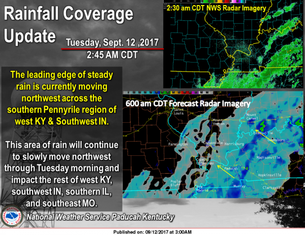
The leading edge of steady rain is currently moving northwest across the southern Pennyrile region of west Kentucky and parts of southwest Indiana. This area of rain will continue to slowly move northwest through Tuesday morning and impact the rest of west Kentucky, southwest Indiana, southern Illinois, and southeast Missouri. Rainfall amounts will initially be around one tenth of an inch by 6 am CDT with greater rainfall amounts possible with heavier rainfall. (NWS Paducah)
…Remnants of Irma will bring gusty winds this morning…
…LAKE WIND ADVISORY REMAINS IN EFFECT UNTIL NOON CDT TODAY…
* TIMING…Brisk winds will continue this morning.
* WINDS…Expect northeast winds to average around 15 mph, with
frequent gusts over 20 mph. Some gusts up to 30 mph are
possible, especially from the Kentucky Lakes region eastward to
the Pennyrile region of western Kentucky.
* IMPACTS…Small watercraft will be susceptible to capsizing or
taking on water. Expect numerous white caps on larger fetches of
water.
PRECAUTIONARY/PREPAREDNESS ACTIONS…
A Lake Wind Advisory indicates that winds will cause rough chop
on area lakes. Small boats will be especially prone to capsizing.
Hazardous Weather Outlook
This Hazardous Weather Outlook is for portions of southern
Illinois, southwest Indiana, western Kentucky, and southeast
Missouri.
.DAY ONE…Today and Tonight
A Lake Wind Advisory is in effect for area boaters this morning.
Northeast winds could gust from 20 to 30 MPH at times. Please
refer to the Lake Wind Advisory product for details.
.DAYS TWO THROUGH SEVEN…Wednesday through Monday
No hazardous weather is expected at this time.
Seven Day Forecast
Tuesday
A slight chance of rain before 7am, then showers likely, mainly between 7am and 11am. Cloudy, with a high near 68. Northeast wind around 15 mph, with gusts as high as 25 mph. Chance of precipitation is 60%.
Tuesday Night
A 50 percent chance of showers. Cloudy, with a low around 61. East northeast wind 5 to 7 mph.
Wednesday
A 40 percent chance of showers. Cloudy, with a high near 70. Light and variable wind.
Wednesday Night
Mostly cloudy, with a low around 59. Calm wind.
Thursday
Mostly sunny, with a high near 81. Calm wind.
Thursday Night
Mostly clear, with a low around 60. Light south southeast wind.
Friday
Sunny, with a high near 84. Calm wind becoming south around 6 mph in the afternoon.
Friday Night
Mostly clear, with a low around 63. South southeast wind 3 to 5 mph.
Saturday
Sunny, with a high near 85. South wind 3 to 6 mph.
Saturday Night
Mostly clear, with a low around 64. South southeast wind around 5 mph becoming calm in the evening.
Sunday
Mostly sunny, with a high near 86. Calm wind becoming south southwest around 5 mph in the afternoon.
Sunday Night
Partly cloudy, with a low around 65. Light south wind.
Monday
Mostly sunny, with a high near 86. Calm wind becoming west southwest around 5 mph in the afternoon.


Speak Your Mind
You must be logged in to post a comment.