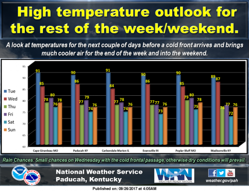
This chart shows high temperatures for the rest of the week and weekend. As far as low temperatures, we will see lows in the upper 60s tonight but much cooler readings in the upper 50s to lower 60s will occur on Wednesday night. Even cooler readings in the lower 50s (upper 40s for some locales) are forecast for the end of the week and weekend, before rebounding early next week. (NWS Paducah)
Seven Day Forecast
Today
Patchy fog before 8am. Otherwise, mostly sunny, with a high near 91. Light and variable wind.
Tonight
Partly cloudy, with a low around 68. Light and variable wind.
Wednesday
A 20 percent chance of showers after 1pm. Partly sunny, with a high near 84. North wind 5 to 9 mph.
Wednesday Night
Partly cloudy, with a low around 57. North wind around 6 mph.
Thursday
Sunny, with a high near 78. North wind 6 to 8 mph.
Thursday Night
Mostly clear, with a low around 52. North wind around 5 mph becoming calm in the evening.
Friday
Sunny, with a high near 79. Calm wind becoming north 5 to 8 mph in the morning.
Friday Night
Mostly clear, with a low around 50. Northeast wind around 6 mph.
Saturday
Sunny, with a high near 74. East northeast wind 5 to 7 mph.
Saturday Night
Mostly clear, with a low around 49. East wind 3 to 5 mph.
Sunday
Sunny, with a high near 76. East wind 3 to 6 mph.
Sunday Night
Partly cloudy, with a low around 54. Southeast wind around 5 mph.
Monday
Mostly sunny, with a high near 80. South wind 5 to 9 mph.


Speak Your Mind
You must be logged in to post a comment.