……Showers and thunderstorms Saturday Night into Sunday
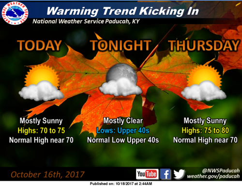
The warming trend will really start to kick in during the middle to latter portion of this work week. Today’s temperatures will return us to near our mid October seasonal norms, with Highs in the lower half of the 70s, and lows in the upper half of the 40s. Thursday highs rise further still, approaching 80 in some locations, with all of us averaging about 5 to 10 degrees above the seasonal norm. (NWS Paducah)
Hazardous Weather Outlook
.DAY ONE…Today and Tonight
Patchy early morning fog is possible. Relative humidity will drop
through the 30s percentile this afternoon for the entire Quad
State, with minimum relative humidity lowest values near 30
percent in the southeast Missouri Ozarks.
.DAYS TWO THROUGH SEVEN…Thursday through Tuesday
Saturday night into Sunday offers the next best chance of
thunderstorms, with locally heavy rain and lightning the primary
storm hazards anticipated.
Seven Day Forecast


Speak Your Mind
You must be logged in to post a comment.