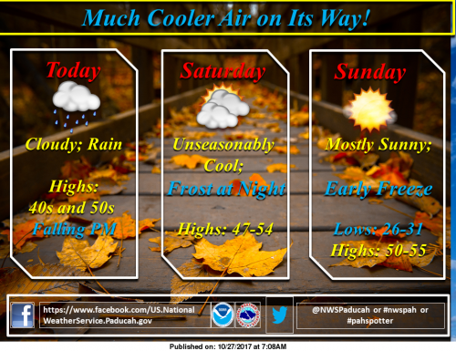
Rains today will usher in a much cooler weather pattern that will last through the weekend. Expect a widespread freeze Saturday night. (NWS Paducah)
Freeze Watch
…FREEZE WATCH IN EFFECT FROM LATE SATURDAY NIGHT THROUGH SUNDAY
MORNING…
The National Weather Service in Paducah has issued a Freeze
Watch, which is in effect from late Saturday night through Sunday
morning.
* TEMPERATURE…Most locations will fall into the 25 to 30 degree
range by sunrise Sunday morning.
* IMPACTS…Sensitive vegetation may be damaged or killed.
PRECAUTIONARY/PREPAREDNESS ACTIONS…
A Freeze Watch means sub-freezing temperatures are possible.
These conditions could kill crops and other sensitive vegetation.
Special Weather Statement
…Areas of frost possible later tonight into Saturday…
Cold Canadian air will begin to filter into the quad state region
today, behind a cold front that will pass from west to east across
the area this morning. Rain is expected to occur after the front
passes, but skies should clear tonight in many locations, allowing
temperatures to fall into the lower and mid 30s.
Some of the colder, sheltered locations may even experience a light freeze.
Winds staying up in the 5 to 10 MPH range are expected to
preclude a widespread frost at this time.
Hazardous Weather Outlook
This Hazardous Weather Outlook is for portions of southern
Illinois, southwest Indiana, western Kentucky, and southeast
Missouri.
.DAY ONE…Today and Tonight
Areas of frost will be possible later tonight into early Saturday.
Some sheltered, normally colder locations may even experience a
light freeze, especially over portions of southeast Missouri and
southern Illinois.
.DAYS TWO THROUGH SEVEN…Saturday through Thursday
Widespread freezing temperatures are expected Saturday night into
early Sunday. Many locations will fall into the mid 20s to near
30 by sunrise Sunday.
.SPOTTER INFORMATION STATEMENT…
Spotter activation will not be needed.
Seven Day Forecast


Speak Your Mind
You must be logged in to post a comment.