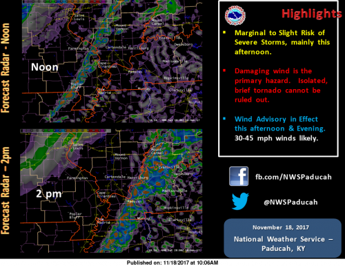
10 AM CST UPDATE… This illustration shows forecast radar imagery (from the HRRR model) at Noon and 2pm CST. This is the forecast model’s interpretation of the expected location of showers and thunderstorms. The line of showers and storms will be along and just ahead of a cold front which will bring quite cold air back into the region for the rest of the weekend. The Storm Prediction Center (SPC) continues to keep a Marginal to Slight Risk for Severe Storms across parts of the Quad State region today. The Slight Risk area is along and east of a line from Perryville to Poplar Bluff Missouri. This includes part of Southeast Missouri, and all of Southern Illinois, Southwest Indiana, and West Kentucky. The Marginal Risk of Severe Storms extends east of a line from Piedmont and Doniphan Missouri and cover a little more of Southeast Missouri. Locally Damaging Wind Gusts and Hail will be the primary concerns, for mainly for the afternoon hours this Saturday. However, given the turning of the winds in the atmosphere, an isolated, brief tornado cannot be ruled out. A line of showers and some thunderstorms will likely start developing into southeast Missouri between 1030 and 1100 am CST and exit the Quad State region completely after 5 pm CST. A Wind Advisory remains in effect today and into early this evening. Wind gusts outside of showers and thunderstorms could reach between 30 and 45 mph. Stay tuned to the latest forecasts, as well as statements and possible warnings later today!!! (NWS- Paducah)


Speak Your Mind
You must be logged in to post a comment.