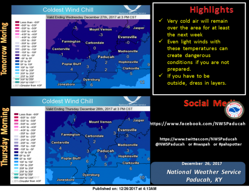
Wind chills the next two mornings will be very cold, generally in the single digits to just below zero. These can be very dangerous if you are not prepared. Dress in layers if you have to be outside. (NWS Paducah)
Hazardous Weather Outlook
.DAY ONE…Today and Tonight
A few flurries or snow showers this afternoon may produce some
very minor snow accumulations, generally just a dusting.
Very cold air even with light winds will produce wind chills
ranging from 5 below zero to 5 above very late tonight.
.DAYS TWO THROUGH SEVEN…Wednesday through Monday
Very cold air will remain over the region through the period. Wind
chills on New Years morning are expected to range from zero to 10
below zero.
.SPOTTER INFORMATION STATEMENT…
Spotter activation is not anticipated.
Seven Day Forecast
Today
A chance of flurries with a slight chance of snow before 1pm, then a slight chance of snow between 1pm and 5pm, then a chance of flurries after 5pm. Mostly cloudy, with a high near 24. North northeast wind around 8 mph. Chance of precipitation is 20%.
Tonight
A chance of flurries before midnight. Mostly cloudy, then gradually becoming mostly clear, with a low around 9. Wind chill values as low as -1. North wind around 8 mph.
Wednesday
Sunny, with a high near 19. Wind chill values as low as -2. North northeast wind 6 to 8 mph.
Wednesday Night
Partly cloudy, with a low around 10. Wind chill values as low as zero. Northeast wind around 6 mph.
Thursday
Partly sunny, with a high near 27. East northeast wind around 6 mph becoming calm in the afternoon.
Thursday Night
Mostly cloudy, with a low around 17. Calm wind becoming west northwest around 5 mph after midnight.
Friday
Partly sunny, with a high near 30. West northwest wind around 5 mph becoming light and variable in the afternoon.
Friday Night
Mostly cloudy, with a low around 16. North northeast wind 3 to 6 mph.
Saturday
A slight chance of snow after noon. Partly sunny, with a high near 23. North wind 6 to 8 mph.
Saturday Night
A chance of snow. Mostly cloudy, with a low around 9. North wind around 7 mph.
Sunday
A chance of snow. Partly sunny, with a high near 19. North wind around 7 mph.
Sunday Night
Mostly cloudy, with a low around 6. North northwest wind around 7 mph.
New Year’s Day
Mostly sunny, with a high near 18. North northwest wind around 8 mph.


Speak Your Mind
You must be logged in to post a comment.