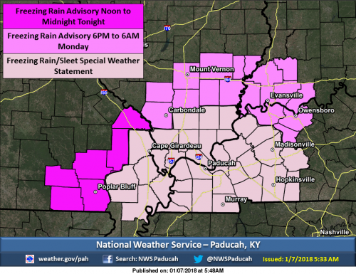
An upper level system moving across the area will produce rain, which may begin as freezing rain or sleet for a short period of time before changing over to all rain. Even though air temperatures are expected to rise to just above freezing in many communities, very cold ground temperatures are expected to lag the slightly warmer air temperatures. This will result in the light rain freezing on contact until the ground has more of a chance to thaw. The best chance for these conditions will begin in portions of southeast Missouri by Noon, and over portions of southern Illinois, southwest Indiana and the northern Kentucky Pennyrile area by 6 PM this evening. A special weather advisory is in effect for the remainder of the area, where there is slight chance of freezing rain development. (NWS Paducah)
Winter Weather Advisory
…WINTER WEATHER ADVISORY IN EFFECT FROM 6 PM THIS EVENING TO
6 AM CST MONDAY…
* WHAT…Freezing rain expected. The ice will result in difficult
travel conditions. Total ice accumulations of less than one
tenth of an inch are expected.
* WHERE…Portions of southern Illinois, southwest Indiana and
western Kentucky.
* WHEN…6 PM today to 6 AM Monday.
* ADDITIONAL DETAILS…Even though air temperatures are expected
to rise to just above freezing in many locations, very cold
ground temperatures are expected to lag the slightly warmer air
temperatures. This will result in light rain freezing on contact
until the ground has more of a chance to thaw.
PRECAUTIONARY/PREPAREDNESS ACTIONS…
A Winter Weather Advisory means that periods of freezing rain
will cause travel difficulties. Be prepared for slippery roads.
Slow down and use caution while driving. The latest road
conditions for the state you are calling from can be obtained by
calling 5 1 1.
Hazardous Weather Outlook
.DAY ONE…Today and Tonight
A wintry mix of precipitation is expected to develop over
southeast Missouri this afternoon and spread across the entire
area tonight. A Winter Weather Advisory has been issued for
portions of southeast Missouri, southern Illinois, southwest
Indiana and far northwest Kentucky. Please refer to the Advisory
product and the Special Weather Statement for more details.
.DAYS TWO THROUGH SEVEN…Monday through Saturday
A storm system will affect the entire area Thursday night into
Friday night. A brief wintry mix will be possible Thursday night
into early Friday morning, with precipitation becoming all snow late
Thursday night into Friday from west to east. At this time, it
looks like some snow accumulation will be possible.
.SPOTTER INFORMATION STATEMENT…
Spotter activation will not be needed. However, spotters are asked
to relay any reports of winter weather or slick roadways to the
National Weather Service.
Seven Day Forecast


Speak Your Mind
You must be logged in to post a comment.