Considerable uncertainty exists in the forecast of a winter storm system to impact the region Tuesday night.
This could be one of these systems that we could see nothing, or we could be dealing with a mess on Wednesday morning. Here in Franklin County we are right on the edge of the rain and snow line. Using a Jim Rasor term, we could see a mixed bag of precipitation. Below are a few graphics at this time, how much we are going to possibly get.
There is another round of wintry weather in the forecast from Friday night into Saturday night.
I will update this again this evening. -sd
Weather Prediction Center images
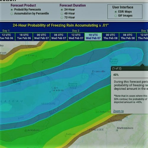
The Graphic above shows the chances of seeing between 1/100 to 1/10 of an inch of ice. The 40% line to 50% line cuts through the heart of Franklin County. All of the totals are from noon on Wednesday when the system should be clear of the area.
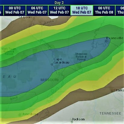
This graphic shows the percentage of receiving a tenth to a quarter of inch of freezing rain. Franklin County is right in the 30% range. The area shaded just south and east of us is in the 40% range.
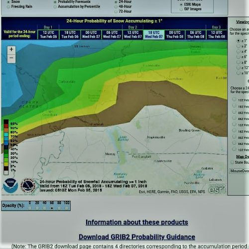
This graphic displays total snow fall for the storm being in the 1″ to 2″ . Franklin County is in the 30% range on this one as well. When you adjust the graphic to 2″ to 4″. the chances are nearly non existent for that much snow.
Special Weather Statement
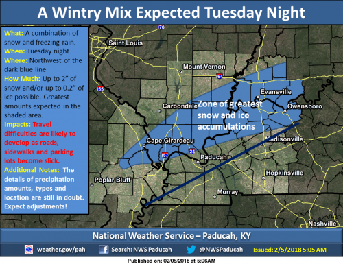
…Wintry Precipitation May Cause Travel Impacts Tuesday night into Early Wednesday Morning… Precipitation is expected to spread northeast across the region late Tuesday afternoon into the evening hours.
The heaviest precipitation is expected near a frontal boundary over northern Tennessee, but it is uncertain how far north across our region the precipitation will spread. At this time, it appears that the zone from Cape Girardeau Missouri to Evansville Indiana is the most likely region to receive significant precipitation with temperatures below freezing. Areas farther to the north will not see much precipitation, while areas farther south will likely remain above freezing for most of the event.
Some snow is likely as the precipitation develops Tuesday evening, but it will transition to freezing rain before coming to an end in the pre-dawn hours Wednesday. At this time, the potential exists for up to 2 inches of snow and or 2 tenths of an inch of icing in the area north and west of a Hickman to Calhoun Kentucky line. Please stay abreast of the latest forecasts for this developing weather event and be prepared to alter plans where possible.
Hazardous Weather Outlook
.DAY ONE…Today and Tonight A small chance of light snow is forecast this evening to the north of Highway 13 in southern Illinois and across southwest Indiana. A light dusting will be possible mainly along and north of Interstate 64.
.DAYS TWO THROUGH SEVEN…Tuesday through Sunday A wintry mix of precipitation is expected Tuesday night over much of the region. Please refer to the Special Weather Statement for details. A wintry mix of precipitation is possible Friday night and Saturday morning, and again Saturday night. It is too early to speculate on precipitation type and amounts.
Seven Day Forecast


Speak Your Mind
You must be logged in to post a comment.