A taste of late March weather this afternoon

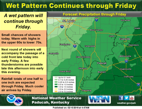
While there will be a chance for showers on today along with much warmer weather, better chances of showers and thunderstorms will arrive late today into tonight and early Friday. Rainfall totals of one half to one inch are expected through Friday.

Hazardous Weather Outlook

.DAY ONE…Today and Tonight A few thunderstorms are possible late this afternoon into early this evening along and north of a line from Greenville Missouri to Cape Girardeau to Evansville Indiana. Severe storms are not expected, but brief heavy rainfall is possible. .

DAYS TWO THROUGH SEVEN…Friday through Wednesday Light snow, possibly mixed with a little sleet and freezing rain, is expected Saturday morning. A dusting to a couple of tenths of an inch of snow is possible mainly in southeast Missouri and southern Illinois, but any accumulations should melt by early afternoon. A prolonged period of wet weather is forecast to set up over the Ohio and Mississippi River Valleys next week. As such, the potential for flooding will need to be monitored in the coming days as we gain a better idea of where and exactly how much rainfall may occur. There is a chance of thunderstorms from Monday night into Tuesday night. Severe weather is not anticipated. .

SPOTTER INFORMATION STATEMENT… Spotter activation will not be needed.

Seven Day Forecast

Today
A chance of showers before 3pm, then a chance of showers and thunderstorms between 3pm and 5pm, then showers likely and possibly a thunderstorm after 5pm. Cloudy, with a high near 70. South southwest wind 10 to 18 mph, with gusts as high as 30 mph. Chance of precipitation is 60%.
Tonight
Rain and possibly a thunderstorm before 1am, then rain likely. Low around 36. South southwest wind 11 to 15 mph becoming north northwest after midnight. Winds could gust as high as 25 mph. Chance of precipitation is 80%.
Friday
A chance of rain, mixing with snow after 11am, then gradually ending. Cloudy, then gradually becoming mostly sunny, with a high near 41. North northwest wind 7 to 15 mph, with gusts as high as 25 mph. Chance of precipitation is 40%.
Friday Night
Partly cloudy, with a low around 28. North wind around 6 mph becoming light and variable in the evening.
Saturday
A slight chance of snow before 9am, then a chance of rain and snow between 9am and 10am, then a chance of rain after 10am. Mostly cloudy, with a high near 43. Light and variable wind becoming southeast 5 to 7 mph in the morning. Chance of precipitation is 50%.
Saturday Night
Mostly clear, with a low around 28. West southwest wind around 6 mph becoming light and variable after midnight.
Sunday
Mostly sunny, with a high near 52. Light southeast wind becoming south southeast 5 to 9 mph in the morning.
Sunday Night
Showers likely, mainly after midnight. Mostly cloudy, with a low around 46. South wind 9 to 13 mph, with gusts as high as 20 mph.
Washington’s Birthday
Showers, mainly before noon. Cloudy, with a high near 65. Breezy, with a south southwest wind 14 to 20 mph, with gusts as high as 33 mph.
Monday Night
Showers likely, then showers and possibly a thunderstorm after midnight. Cloudy, with a low around 55. South southwest wind 14 to 16 mph, with gusts as high as 25 mph.
Tuesday
Showers likely. Cloudy, with a high near 63. Southwest wind 10 to 14 mph, with gusts as high as 21 mph.
Tuesday Night
Showers likely. Cloudy, with a low around 42. South southwest wind 10 to 13 mph.
Wednesday
A chance of showers. Mostly cloudy, with a high near 50. West wind 9 to 13 mph becoming north in the morning.

Speak Your Mind

Benton, West Frankfort, Illinois News | Franklin County News