There have not been any reports of road closures this morning. I would use my own discretion about driving on roads across the county that are flood prone. Do not drive around barricades. We have two days to dry out before we receive another round of precipitation again, Tuesday night into Wednesday. -sd
Flood Warning for the Big Muddy
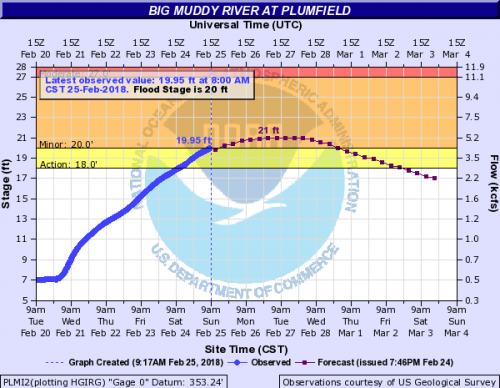
The Flood Warning continues for the Big Muddy River near Plumfield.
* from Sunday afternoon to Thursday morning.
* At 9:00 PM Saturday the stage was 19.0 feet.
* Flood Stage is 20.0 feet.
* Minor flooding is forecast.
* Forecast…Rise above flood stage by tomorrow afternoon and continue to rise to near 21.0 feet by early Tuesday morning. The river will fall below flood stage by early Thursday morning.
* Impact…At 20.0 Feet…Minor flooding occurs affecting mainly bottom-land and surrounding low lying areas.
Hazardous Weather Outlook
This Hazardous Weather Outlook is for portions of southern Illinois, southwest Indiana, western Kentucky, and southeast Missouri. .
DAY ONE…Today and Tonight Flood Warnings remain in effect across the entire area as flood waters will be slow to recede today. Numerous river flood warnings are also in effect. Refer to the warning products and their follow up statements for more details. .
DAYS TWO THROUGH SEVEN…Monday through Saturday One to two inches of rainfall are possible during the Tuesday night to Thursday time frame. River flood warnings will remain in effect into next week. Refer to the flood warnings and statements for important river flood details, including the latest updated information. .
SPOTTER INFORMATION STATEMENT… Reports of any damage from the Saturday evening thunderstorms would be appreciated, along with any ongoing flood issues or rainfall totals.
Seven Day Forecast


Speak Your Mind
You must be logged in to post a comment.