by Steve Dunford
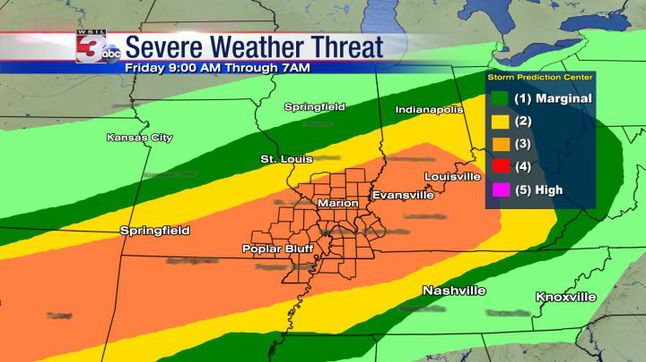
SPC places Southern Illinois at level 3 for Severe threat. We believe focus time is later day and overnight. Look for live stream as storms approach. (WSIL TV Chief Meteorologist Jim Rasor) A personal note from me. We have three very good weather teams in this market. You will not go wrong with channels three, six or twelve. Personally during a severe weather threat, I always monitor channel 12 first, then when it approaches Southern Illinois, I flip between the two. )
Over the next seventy two hours we will have a risk for severe weather over the weekend. Today is an enhanced risk and Saturday and Sunday is a slight risk.
The main reason we are under an enhanced risk today is the risk for large hail. Damaging thunderstorm winds and isolated tornadoes will be a risk throughout the weekend.
This is a storm system that will be a challenge to forecasters. We have an advancing warm front that will become stationary across the region. It will convert into a cold front and pass the region sometime on Sunday.
This will wobble back and forth. Right now with cloud cover and around 60 degrees I am wondering if the front has gone stationary right now and we are in the cold sector. As long as the cloud cover remains, there will be a cap among the atmosphere. Looking at the latest radar, I would say the front is in the route 50 corridor now.
For high school sporting events as long as the cloud cover remains, we should get the games in with some passing sprinkles. If the sun pops out, it might be another Athletic Director’s nightmare as pop up thunderstorms could form.
This is one of those forecasts that will be updated frequently. That is why it is important not to have fear but be aware over the weekend.
There is a site out there on social media that has a doomsday scenario painted for a few Southern Illinois counties, including Franklin for the overnight hours. This is over-sensationalized, and borderline being fake. There is a threat for the possibility of severe weather, and make sure you have your NOAA weather radios on tonight, be aware, but don’t be alarmed until you have to.
We are going to get a lot of rain over the weekend, how much is varying by the models. There are some that is as few as three inches, some as high as seven.
At this time the pool at Rend Lake is 407.1 ft, that is going over the spillway swiftly At 410′ is when concern should start, as water will be flowing over the entire spillway.
The Big Muddy at Plumfield is at 13.2 feet now. It will not reach flood stage until sometime late Saturday or Sunday, which is 20 feet. It is forecasted to crest late Monday afternoon at 22.7 feet.
Below is the information on the Flash Flood Watch and hazardous weather outlook from the National Weather Service from Paducah, KY.
…FLASH FLOOD WATCH REMAINS IN EFFECT FROM THIS EVENING THROUGH LATE SUNDAY NIGHT… The Flash Flood Watch continues for * Portions of southern Illinois, western Kentucky, and southeast Missouri, including the following areas, in southern Illinois, Alexander, Edwards, Franklin, Gallatin, Hamilton, Hardin, Jackson, Jefferson, Johnson, Massac, Perry IL, Pope, Pulaski, Saline, Union, Wabash, Wayne IL, White, and Williamson. In western Kentucky, Ballard, Carlisle, Fulton, Hickman, and McCracken. In southeast Missouri, Bollinger, Butler, Cape Girardeau, Carter, Mississippi, New Madrid, Perry MO, Ripley, Scott, Stoddard, and Wayne MO. * From this evening through late Sunday night *
The watch is generally in effect for locations along and west of a line extending from near Fulton, Kentucky to Mount Carmel, Illinois, including all of southeast Missouri and southern Illinois. Much of this region already received 1.5 to 3 inches of rainfall Wednesday and Wednesday night. Numerous thunderstorms with very heavy rain are expected to develop later this afternoon and continue tonight. Some areas of western Kentucky and the southern tip of Illinois may see a break in the precipitation Saturday into Saturday night, but will then see more thunderstorms with very heavy rainfall move in from the west late Saturday night and through the day Sunday. From 3 to 6 inches of rain could fall in the watch area by the time the entire event is finished Sunday night. Locally higher amounts are also possible where numerous thunderstorms repeat. * In addition to the possibility of flash flooding of some roadways and streams, the heavy rainfall is expected to cause rises on many of the area rivers, particularly the smaller rivers in southeast Missouri, such as the Saint Francis, Black, and Current
. PRECAUTIONARY/PREPAREDNESS ACTIONS… A Flash Flood Watch means that conditions may develop that lead to flash flooding. Flash flooding is a very dangerous situation. You should monitor later forecasts and be prepared to take action should Flash Flood Warnings be issued.
Flood Warning National Weather Service Paducah Kentucky 948 AM CDT Fri Apr 28 2017 ...
The National Weather Service in Paducah, Kentucky has issued a flood warning for a portion of the Big Muddy River affecting areas in southwest Illinois… Near Plumfield affecting Franklin and Williamson Counties. .Due to heavy rainfall across the river basin over the past couple of days, and anticipated rainfall expected over the weekend, water levels are expected to rise above flood stage along the Big Muddy River near Plumfield later this weekend and crest early next week. PRECAUTIONARY/PREPAREDNESS ACTIONS… SAFETY MESSAGE… Never drive cars…trucks or sport utility vehicles through flooded areas. The water may be too deep to allow safe passage. Never allow children to play in or near flood waters. Stay tuned to NOAA Weather Radio or your local media for further statements and possible updated forecasts.
This Hazardous Weather Outlook is for portions of southern Illinois, southwest Indiana, western Kentucky, and southeast Missouri. .
DAY ONE…Today and Tonight Scattered severe thunderstorms will be possible this afternoon and tonight over the entire quad state region. Very large hail be possible in the stronger storms, along with damaging wind gusts. Isolated tornadoes will also be possible. In addition, a Flash Flood Watch is in effect for all of southern Illinois, southeast Missouri and the western tip of Kentucky this evening through Sunday evening. From 3 to 6 inches of rainfall may occur over the course of the weekend. East of the watch, additional rains of 1 to 3 inches may occur. Please refer to the watch product for more details. .
DAYS TWO THROUGH SEVEN…Saturday through Thursday A Flash Flood Watch will remain in effect through Sunday evening for multiple rounds of thunderstorms containing very heavy rain. Please refer to the watch product for more details. In addition, scattered severe thunderstorms will continue to be possible periodically through much of the weekend. Large hail and damaging wind gusts are expected to be the main hazards. However, isolated tornadoes cannot be ruled out. There is a chance of thunderstorms over the southern third of the Outlook area on Wednesday. Any storms that develop are not expected to be severe at this time.


Speak Your Mind
You must be logged in to post a comment.