by Steve Dunford
The flash flood threat is over. The National Weather Service in Paducah has issued a Flood Warning for all of Southern Illinois until 5:45 a.m. Monday Morning.
The difference between a Flash Flood Warning and a Flood Warning, a Flash Flood Warning is issued for an event that run off will be fairly quick. A Flood Warning is issued when there is sustained water. They are usually issued for rivers that are above flood stage. Issuing one for a widespread area, is unprecedented.
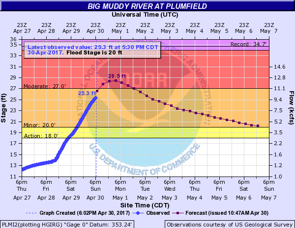
I am going to show a couple graphics, and at the end include the warning text. The first is the Big Muddy at Plumfield.

As you can see the Big Muddy has risen twelve feet over the last 48 hours. It should crest in the night and slowly recede below flood stage toward the end of the week. The NWS has severe flooding in the forecast for Murphysboro downstream, and possible record flooding might occur along the Mississippi at Cape.
I will keep a close eye on this for two reasons. First Rend Lake is getting ready to release a lot of water. Second there is 1-2 more inches of rain in the forecast from Tuesday night into Wednesday.
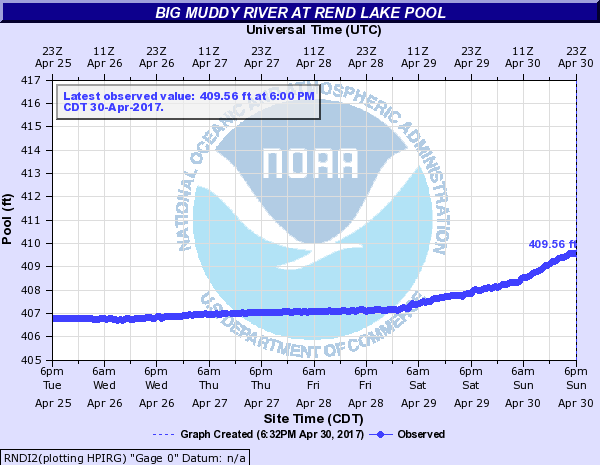
Here is a graphic for the headwaters at Rend Lake. 
I spoke to a representative from the Army Corps of Engineers on Friday and they said that at 410′ water will go over the entire spillway. I will keep in contact with them for possible closure of facilities, and possible flooding on Rend City road. If water will go over the auxiliary spillway, Rend Lake Dam road might close.
Here is the full text for the Flood Warning:
The National Weather Service in Paducah has issued a * Flood Warning for… Perry County in south central Illinois… White County in southeastern Illinois… Wayne County in south central Illinois… Wabash County in southeastern Illinois… Jefferson County in south central Illinois… Edwards County in southeastern Illinois… Williamson County in southern Illinois… Saline County in southern Illinois… Jackson County in southern Illinois…
FRANKLIN COUNTY IN SOUTH CENTRAL ILLINOIS. Hamilton County in south central Illinois… * Until 545 AM CDT Monday * At 538 PM CDT, flooding continued in many areas. The threat for heavy rainfall is over. However, flooding along rivers, creeks and streams will continue, along with numerous water covered, flooded roads. The dangers will increase tonight as the dangers of flooding become harder to recognize. * Some locations that will experience flooding include… Carbondale, Marion, Mount Vernon, Herrin, Harrisburg, West Frankfort, Murphysboro, Mount Carmel, Benton, Du Quoin, Pinckneyville, Carterville, Carmi, Fairfield, Eldorado, Johnston City, McLeansboro, Christopher, Albion and Rend Lake Area.
PRECAUTIONARY/PREPAREDNESS ACTIONS… Turn around, don`t drown when encountering flooded roads. Most flood deaths occur in vehicles. Be especially cautious at night when it is harder to recognize the dangers of flooding. Excessive runoff from heavy rainfall will cause flooding of small creeks and streams, country roads, farmland, and other low lying spots.


Speak Your Mind
You must be logged in to post a comment.