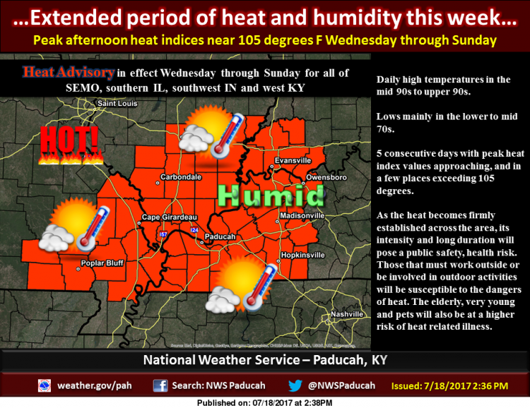
…Dangerous heat and humidity Wednesday through Sunday…
.A large upper level high will produce a dome of heat and
humidity across the region from Wednesday through Sunday. The
combination of the heat and humidity will produce maximum heat
index values over 100 degrees each day from the late morning
to late afternoon hours, with peak heat index values pushing 105
degrees or slightly higher some areas. Actual high temperatures
will be in the mid 90s, and in a few places upper 90s.
…HEAT ADVISORY IN EFFECT FROM NOON WEDNESDAY TO 7 PM CDT
SUNDAY…
The National Weather Service in Paducah has issued a Heat
Advisory, which is in effect from noon Wednesday to 7 PM CDT
Sunday for all of southeast Missouri, southern Illinois, southwest
Indiana and western Kentucky. The Excessive Heat Watch is no
longer in effect.
* TIMING…Wednesday afternoon through Sunday evening.
* HEAT INDEX VALUES…topping the 100 degree mark from midday
through late afternoon, peaking near 105 degrees or slightly
higher in some areas.
* IMPACTS…The combination of hot temperatures and high humidity
will lead to an increased risk of heat related stress and
illness. The very young, the elderly, those without air
conditioning, and those participating in strenuous outdoor
activities will be the most susceptible. Also, car interiors
will reach lethal temperatures in a matter of minutes.
PRECAUTIONARY/PREPAREDNESS ACTIONS…
A Heat Advisory means that a period of hot temperatures is
expected. The combination of hot temperatures and high humidity
will combine to create a situation in which heat illnesses are
possible. Drink plenty of fluids…stay in an air-conditioned
room…stay out of the sun…and check up on relatives and
neighbors.


Speak Your Mind
You must be logged in to post a comment.