NWS Paducah image
Eclipse forecast for Monday August 21, 2017, Sunny with a highs in the upper 80’s.
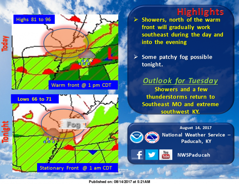
Hazardous Weather Outlook
National Weather Service Paducah KY
.DAY ONE…Today and Tonight
An isolated thunderstorm is possible near the Kentucky and
Tennessee border late this afternoon, mainly east of the Land
Between The Lakes. Otherwise, no hazardous weather is anticipated
today or tonight.
.DAYS TWO THROUGH SEVEN…Tuesday through Sunday
Scattered thunderstorm activity will expand west-to-east across
most of the region by Tuesday evening, and will be common across
the region through the day Thursday. A few strong storms cannot be
ruled out. Another system may provide isolated thunderstorms
during the first half of the weekend.
Heat indices greater than 100 are possible at some locations
Wednesday and Thursday afternoons.
.SPOTTER INFORMATION STATEMENT…
Spotter activation is not anticipated.
Seven Day Forecast
Today
Isolated showers between 7am and 11am. Patchy fog before 9am. Otherwise, mostly cloudy, with a high near 86. Light and variable wind. Chance of precipitation is 20%.
Tonight
Patchy fog between 10pm and 2am. Otherwise, partly cloudy, with a low around 69. Light south wind.
Tuesday
A 20 percent chance of showers and thunderstorms after 4pm. Patchy fog before 7am. Otherwise, partly sunny, with a high near 87. Calm wind becoming south southwest around 6 mph in the afternoon.
Tuesday Night
A 40 percent chance of showers and thunderstorms, mainly after 1am. Mostly cloudy, with a low around 71. Light south wind.
Wednesday
A 50 percent chance of showers and thunderstorms. Partly sunny, with a high near 88. Light south wind becoming south southwest 5 to 9 mph in the morning.
Wednesday Night
A 40 percent chance of showers and thunderstorms. Mostly cloudy, with a low around 75. South wind 5 to 7 mph.
Thursday
A 50 percent chance of showers and thunderstorms. Mostly cloudy, with a high near 88. Southwest wind around 8 mph.
Thursday Night
A slight chance of showers and thunderstorms before 1am. Partly cloudy, with a low around 69. West northwest wind 3 to 7 mph.
Friday
Mostly sunny, with a high near 87. Northwest wind 3 to 6 mph.
Friday Night
A slight chance of showers after 1am. Partly cloudy, with a low around 68. North northwest wind around 5 mph becoming calm in the evening.
Saturday
A slight chance of showers and thunderstorms. Mostly sunny, with a high near 86. Calm wind becoming southwest around 5 mph in the afternoon.
Saturday Night
A slight chance of showers and thunderstorms. Partly cloudy, with a low around 67. Light southwest wind.
Sunday
Mostly sunny, with a high near 88. Southwest wind 3 to 5 mph.
Tiles © ESRI


Speak Your Mind
You must be logged in to post a comment.