 Hydrologic Forecast
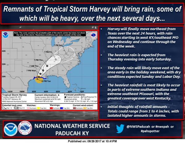
…Remnants of Tropical Storm Harvey To Bring Heavy Rains…
Rainfall associated with Harvey will begin to spread across
portions of western Kentucky and southeast Missouri on Wednesday.
The greatest coverage and intensity of rainfall is expected to
push north into our region from Tennessee late Wednesday night
through Friday evening.
Storm total rainfall amounts are forecast to range from 1 to 4
inches with some higher amounts possible, especially within bands
of heavier thunderstorms. The most likely placement of the
heaviest rain band looks to be over western Kentucky and into far
southeast Missouri and southwest Indiana. There remains some
uncertainty regarding the placement of the heaviest amounts.
However, there is a heightened potential of experiencing rainfall
amounts that may leading to some flooding issues.
Stay tuned for additional statements and headlines regarding this
upcoming heavy rainfall event. Be prepared to take quick and
decisive action should you encounter rising waters or flooding.
Seven Day Forecast
Wednesday
Patchy fog before 8am. Otherwise, partly sunny, with a high near 83. Northeast wind 3 to 7 mph.
Wednesday Night
Mostly cloudy, with a low around 64. Northeast wind 3 to 5 mph.
Thursday
Mostly cloudy, with a high near 82. Northeast wind 5 to 8 mph.
Thursday Night
A 40 percent chance of showers and thunderstorms, mainly after 1am. Mostly cloudy, with a low around 65. Northeast wind 6 to 9 mph.
Friday
Showers likely and possibly a thunderstorm before 1pm, then a chance of showers and thunderstorms after 1pm. Cloudy, with a high near 75. Northeast wind 10 to 13 mph. Chance of precipitation is 70%.
Friday Night
A 40 percent chance of showers and thunderstorms. Mostly cloudy, with a low around 61. North northeast wind 6 to 10 mph.
Saturday
A chance of showers and thunderstorms before 1pm. Partly sunny, with a high near 80. North northwest wind around 6 mph.
Saturday Night
Partly cloudy, with a low around 62. West northwest wind around 5 mph becoming calm in the evening.
Sunday
Mostly sunny, with a high near 84. Light northwest wind.
Sunday Night
Mostly clear, with a low around 64. Light south southwest wind.
Labor Day
Sunny, with a high near 86. South southwest wind 3 to 6 mph.
Monday Night
Partly cloudy, with a low around 63. East wind around 6 mph becoming light and variable after midnight.
Tuesday
A chance of showers and thunderstorms. Mostly sunny, with a high near 81. Northwest wind 5 to 7 mph.


Speak Your Mind
You must be logged in to post a comment.