 The affects of Hurricane Harvey will be to our south and east. The rain chances around here are slim (20%). Points to the south and east of here, the rain chances will increase. There has been heavy rain for the counties along the Ohio river last night in Southern Illinois.
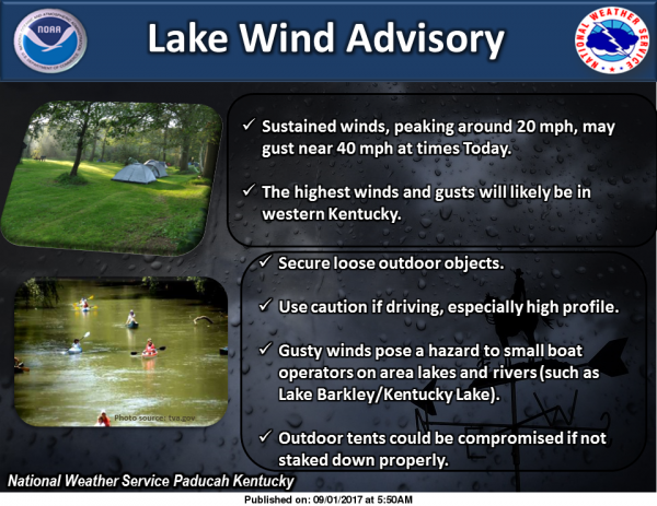
It will be windy, prompting the National Weather Service to issue a Lake Wind Advisory for all of Southern Illinois until 7:00 p.m. this evening.
For Labor Day Weekend, highs will be in the upper 70’s Tomorrow. Sunday and Monday will be much warmer, with highs in the mid to upper 80’s with humidity sneaking back in. There is a chance of storms for Monday night into Tuesday, with another cooling trend with highs in the 70’s. sd
Lake Wind Advisory
…LAKE WIND ADVISORY REMAINS IN EFFECT UNTIL 7 PM CDT THIS
EVENING…
* TIMING… Winds peak this morning through mid afternoon. Winds
will begin to diminish heading toward the evening hours, but may
maintain some gustiness until nightfall or shortly thereafter,
particularly in southwest Indiana and northwest Kentucky.
* WINDS… mean sustained winds will peak near 20 mph with
occasional gusts close to 40 mph possible, especially across
western Kentucky.
* IMPACTS…early holiday weekend recreational activities and
camp set up will be adversely impacted by these strong winds.
Boaters, especially smaller crafts, will find choppy and
increasingly hazardous wave conditions. Land use interests
will similarly be impacted, and given the heavy rains
accompanying the increasing winds, small or decaying trees may
well be toppled or damaged in some locations.
PRECAUTIONARY/PREPAREDNESS ACTIONS…
A Lake Wind Advisory indicates that winds will cause rough chop
on area lakes. Small boats will be especially prone to capsizing.
Hazardous Weather Outlook
.DAY ONE…Today and Tonight
Heavy rain and wind hazards associated with the remnants of
Harvey continue today, with all or parts of the region remaining
under a Flash Flood Watch and Lake Wind Advisory. Reference the
Watch, Advisory, and Warning products, for more detailed Flooding
hazard information. Similarly, reference the Lake Wind Advisory
regarding the ongoing Wind and Gust hazard for additional details.
.DAYS TWO THROUGH SEVEN…Saturday through Thursday
The main chance of storms next week comes with a cold front`s
Tuesday passage. Storm chances enter the forecast from the
northwest Monday night, peak Tuesday, and depart to the southeast with
the front Tuesday night. At this time, lightning and heavy rain
are anticipated to be the main storm associated hazards,
especially during the daytime Tuesday.
.SPOTTER INFORMATION STATEMENT…
Spotter reports of rainfall, flooding, wind, and any other weather
related impact from Harvey are encouraged today.
Hazardous Weather Outlook
Today
A 20 percent chance of showers before 10am. Mostly cloudy, with a high near 73. North northeast wind around 14 mph, with gusts as high as 26 mph.
Tonight
Partly cloudy, with a low around 53. North wind 5 to 8 mph.
Saturday
Sunny, with a high near 77. Northwest wind around 7 mph.
Saturday Night
Clear, with a low around 56. Light west northwest wind.
Sunday
Sunny, with a high near 85. Calm wind becoming west southwest around 5 mph in the afternoon.
Sunday Night
Mostly clear, with a low around 62. Light south southwest wind.
Labor Day
Sunny, with a high near 87. South southwest wind 3 to 8 mph.
Monday Night
A chance of showers and thunderstorms. Partly cloudy, with a low around 65. South southwest wind around 7 mph becoming west after midnight.
Tuesday
A chance of showers and thunderstorms, mainly before 1pm. Partly sunny, with a high near 78. North northwest wind 6 to 8 mph.
Tuesday Night
Partly cloudy, with a low around 53. North northwest wind 3 to 6 mph.
Wednesday
Sunny, with a high near 75. North wind 3 to 8 mph.
Wednesday Night
Mostly clear, with a low around 52. North wind 3 to 6 mph.
Thursday
Sunny, with a high near 76. North wind 3 to 7 mph.


Speak Your Mind
You must be logged in to post a comment.