by Steve Dunford
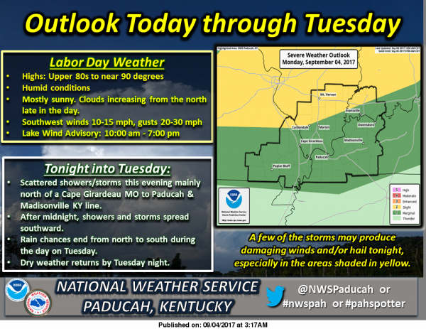
There is a slight risk (level 2 of 5) of severe weather mainly for the overnight hours for the north part of Southern Illinois, including Franklin County . The rest of the region is under a marginal risk (level 1 of 5)
The Storm Prediction Center claims the biggest threat is from damaging winds. There is a minor threat of large hail. The tornado threat is near zero.
One thing I am keeping an eye on is the enhanced risk (level 3 of 5) of severe weather keeps getting closer to our region. Two hours ago, it was just a sliver into Indiana. Now it is from a Mattoon to Kankakee line and east.
I will be up tonight until the severe threat is over. If a watch is issued, I will declare an emergency alert day for the website. My main focus will be covering the severe weather event. I will be sharing things from all three of the TV stations in this market, from the National Weather Service and Franklin County Emergency Management Agency.
Because of how fast information can come in, monitor the website’s Facebook page. The main focus will be Franklin County in events. There will be a significant focus on the six surrounding counties, as the page has been reaching into those markets. There will be an eye kept though, on all the counties from I-64 south.
If you have the day off enjoy it, and take one last dip in the pool.
Here are the advisories in effect and the seven day forecast for Franklin County.
Lake Wind Advisory
…LAKE WIND ADVISORY REMAINS IN EFFECT UNTIL 7 PM CDT THIS
EVENING…
* TIMING…Winds will increase this morning, peaking this
afternoon. Winds will decrease toward sunset. The strongest
winds will be over southwest Indiana and adjacent portions of
Illinois and Kentucky this afternoon.
* WINDS…Peak gusts will be 20 to 30 mph, especially over
southwest Indiana and adjacent portions of Illinois and
Kentucky this afternoon. |
* IMPACTS…Holiday recreational activities, especially boating,
will be the most impacted. Choppy and increasingly hazardous
wave conditions will develop. Long fetches of south to north
oriented lakes and rivers will be most impacted.
PRECAUTIONARY/PREPAREDNESS ACTIONS…
A Lake Wind Advisory indicates that winds will cause rough chop
on area lakes. Small boats will be especially prone to capsizing.
Hazardous Weather Outlook
This Hazardous Weather Outlook is for portions of southern
Illinois, southwest Indiana, western Kentucky, and southeast
Missouri.
.DAY ONE…Today and Tonight
Thunderstorms are forecast Tonight and Tuesday. There is a Slight
Risk of severe thunderstorms across northern parts of southern
Illinois and southwest Indiana. Otherwise, a few strong to severe
storms will be possible tonight. Gusty and potentially damaging winds,
frequent lightning and locally heavy rain may accompany the
stronger storms.
Minor flooding is forecast on parts of the Green River. See the
latest river flood warning products for details.
.DAYS TWO THROUGH SEVEN…Tuesday through Sunday
No hazardous weather is expected at this time.
.SPOTTER INFORMATION STATEMENT…
Spotter activation may be requested tonight.
Seven Day Forecast
Labor Day
Sunny, with a high near 90. Southwest wind around 16 mph, with gusts as high as 23 mph.
Tonight
A 50 percent chance of showers and thunderstorms, mainly after 8pm. Mostly cloudy, with a low around 64. South southwest wind 5 to 8 mph becoming light and variable.
Tuesday
A 20 percent chance of showers and thunderstorms before 10am. Partly sunny, with a high near 76. Northwest wind 5 to 8 mph.
Tuesday Night
Mostly clear, with a low around 51. North northwest wind 3 to 6 mph.
Wednesday
Sunny, with a high near 72. Light northwest wind becoming north northwest 5 to 9 mph in the morning.
Wednesday Night
Mostly clear, with a low around 49. North northwest wind around 6 mph becoming calm in the evening.
Thursday
Sunny, with a high near 73. Calm wind becoming northwest 5 to 7 mph in the morning.
Thursday Night
Mostly clear, with a low around 50. North northwest wind around 5 mph becoming calm in the evening.
Friday
Sunny, with a high near 74. Calm wind becoming north around 5 mph in the afternoon.
Friday Night
Mostly clear, with a low around 50. Light east wind.
Saturday
Sunny, with a high near 74. East wind 3 to 6 mph.
Saturday Night
Mostly clear, with a low around 52. East northeast wind 3 to 5 mph.
Sunday
Sunny, with a high near 75. East northeast wind 5 to 7 mph.


Speak Your Mind
You must be logged in to post a comment.