URGENT – WEATHER MESSAGE
National Weather Service Paducah KY
The National Weather Service in Paducah has issued a Lake Wind
Advisory, which is in effect until noon CDT Tuesday.
* TIMING…Brisk winds will continue this afternoon. There will
be a period of lighter winds this evening, but winds will pick
back up overnight into Tuesday morning.
* WINDS…Expect northeast winds to average around 15 mph this
afternoon, with frequent gusts over 20 mph. After a lull in the
winds this evening, they will pick back up overnight. Winds will
average around 15 mph again Tuesday morning. Gusts up to 30 mph
are possible, especially from the Kentucky Lake area eastward to
the Pennyrile region.
* IMPACTS…Small watercraft will be susceptible to capsizing or
taking on water.
PRECAUTIONARY/PREPAREDNESS ACTIONS…
A Lake Wind Advisory indicates that winds will cause rough chop
on area lakes. Small boats will be especially prone to capsizing.
Hazardous Weather Outlook
This Hazardous Weather Outlook is for portions of southern
Illinois, southwest Indiana, western Kentucky, and southeast
Missouri.
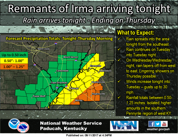
.DAY ONE…This Afternoon and Tonight
A Lake Wind Advisory is in effect for area boaters. Breezy
conditions will continue as the remnants of Irma approach our
region. Please refer to the Lake Wind Advisory product for
details.
.DAYS TWO THROUGH SEVEN…Tuesday through Sunday
The Lake Wind Advisory remains in effect through Tuesday morning
for breezy conditions. Periods of rain will continue with the
remnants of Irma through Wednesday night. Total rainfall amounts
may be locally over an inch over western Kentucky.
.SPOTTER INFORMATION STATEMENT…


Speak Your Mind
You must be logged in to post a comment.