http://www.weather.gov/pah/September2017ClimateSummary

PADUCAH, KY – NOTE: Please click on the link above for an interactive web page from the National Weather Service in Paducah with September climatological statistics. The introduction is below.
September 2017 Climate Summary: Temperatures were above normal with drier than normal conditions for many locations. It was hard to believe the month ended with above normal temperatures after what we endured during the first 2 weeks. Through September 13th, it was actually the coldest start to September on record in Paducah, Evansville, and Cape Girardeau. A major pattern change then followed with abnormally warm and even some record high temperatures set during the September 20th – 27th period. Highs routinely hit the 90s during this stretch. Overall temperatures were around 1 to 2 degrees above normal for September.
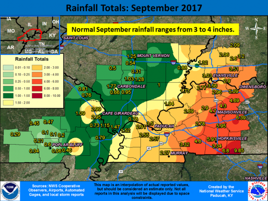
Rain was hard to come by for many locations, with drier than normal conditions (1-3 inch deficits) common across southeast Missouri, southern Illinois, and the Jackson Purchase area of west Kentucky. The Ozark foothills in Missouri observed the least rainfall with some locations picking up less than 0.25”. The Poplar Bluff, MO airport received only 0.06” for the entire month! The exception to the dryness was in part of the Pennyrile region of west Kentucky into a portion of southwest Indiana. This area experienced heavier rainfall associated with the remnants of Hurricane Harvey on the 1st of the month and the remnants of Hurricane Irma on the 12th – 13th, which resulted in wetter than normal conditions.


Speak Your Mind
You must be logged in to post a comment.