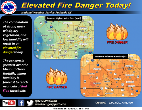
The combination of strong gusty winds, dry vegetation, and low humidity will result in an elevated fire danger today. The concern is greatest over the Missouri Ozark foothills, where humidity is forecast to reach near critical Red Flag thresholds. (NWS Paducah)
Deep low pressure will move from the Upper Midwest southeast to
the Ohio Valley region today. Strong and gusty southwest winds
will occur out ahead of an approaching cold front associated with
the low pressure system.
WIND ADVISORY IN EFFECT FROM 10 AM THIS MORNING TO 4 PM CST
THIS AFTERNOON
The National Weather Service in Paducah has issued a Wind
Advisory, which is in effect from 10 AM this morning to 4 PM CST
this afternoon.
* TIMING…Highest wind gusts from mid morning through mid
afternoon.
* WINDS…From the southwest gusting to around 40 mph at times.
* IMPACTS…Driving will be more difficult for high profile
vehicles. Outdoor objects, including holiday decorations not
secure may be blown around or damaged.
PRECAUTIONARY/PREPAREDNESS ACTIONS…
A wind advisory is issued when sustained winds are expected to
reach 30 mph or greater for longer than one hour…or wind gusts
are expected to reach 40 mph for any duration.
Elevated Fire Danger Today
The combination of strong gusty winds and dry vegetation will
result in an elevated fire danger today across the Quad State
region. Relative humidity will also be quite low and may even
approach Red Flag criteria this afternoon, particularly over the
Ozark foothills of southeast Missouri.
These weather conditions along with very dry grasses and
underbrush could result in the rapid spread of fires. Burn bans
are in effect for some counties and outdoor burning is highly
discouraged across the region. Check with local authorities for
the latest on area burn bans.
Conditions should improve significantly by sunset as winds
slacken and humidity recovers.
Seven Day Forecast
Today
Sunny, with a high near 56. Breezy, with a south southwest wind 10 to 15 mph increasing to 18 to 23 mph in the afternoon. Winds could gust as high as 39 mph.
Tonight
Partly cloudy, with a low around 26. West wind 8 to 13 mph becoming north northwest after midnight. Winds could gust as high as 22 mph.
Thursday
Partly sunny, with a high near 38. North wind 3 to 7 mph.
Thursday Night
Mostly cloudy, with a low around 23. Light and variable wind.
Friday
Mostly sunny, with a high near 43. Light west wind increasing to 5 to 9 mph in the morning.
Friday Night
Mostly clear, with a low around 27. Southwest wind around 6 mph.
Saturday
Sunny, with a high near 50. South southwest wind 5 to 11 mph.
Saturday Night
A chance of rain, mainly after midnight. Partly cloudy, with a low around 37. South wind 6 to 8 mph.
Sunday
Rain likely, mainly before noon. Mostly cloudy, with a high near 47. South wind 5 to 7 mph becoming west in the afternoon.
Sunday Night
A slight chance of rain before midnight. Mostly cloudy, with a low around 33. West northwest wind 3 to 5 mph.
Monday
Mostly sunny, with a high near 49. West wind 3 to 7 mph.
Monday Night
Partly cloudy, with a low around 34. West southwest wind around 6 mph.
Tuesday
Sunny, with a high near 51. West wind 6 to 9 mph.


Speak Your Mind
You must be logged in to post a comment.