Special Weather Statement
..Below zero wind chills expected early today…
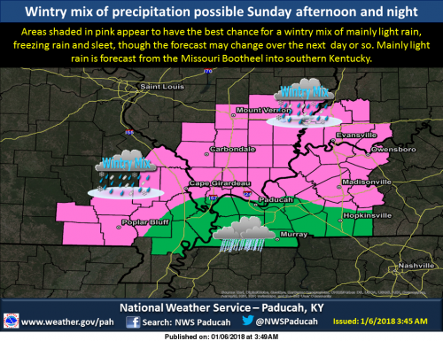
…Light wintry precipitation possible Sunday afternoon into
Sunday night…
Another Arctic high pressure system will move southeast into the
Ohio Valley today. Morning temperatures will be in the single
digits and teens, except teens in parts of southeast Missouri.
Wind chills early today will be running from zero to 8 below in
much of the area east of the Mississippi River.
A south wind flow will develop on Sunday and Sunday night. The
south winds will bring moisture northward, setting the stage for
widespread light precipitation. The precipitation will spread
from west to east across our region Sunday afternoon and evening,
continuing into Monday morning. In some areas, the precipitation
may be in the form of a wintry mix of sleet and freezing rain
before enough warm air changes it to liquid rain by Monday
morning. Although heavy amounts are not expected, travel could be
impacted later Sunday afternoon into Sunday night if surface
temperatures fall back close to the freezing mark.
Seven Day Forecast
Today
Sunny, with a high near 22. Wind chill values as low as -1. East northeast wind around 6 mph.
Tonight
Increasing clouds, with a low around 15. South southeast wind 5 to 8 mph.
Sunday
A chance of snow before 1pm, then a chance of rain, snow, and freezing rain between 1pm and 4pm, then a chance of rain or freezing rain after 4pm. Mostly cloudy, with a high near 36. South wind 7 to 11 mph. Chance of precipitation is 40%.
Sunday Night
Rain. Low around 34. South wind 7 to 11 mph. Chance of precipitation is 90%.
Monday
Rain likely before noon. Mostly cloudy, with a high near 41. South wind 3 to 6 mph. Chance of precipitation is 60%.
Monday Night
Partly cloudy, with a low around 30. Light and variable wind.
Tuesday
Partly sunny, with a high near 44. Calm wind becoming east around 6 mph in the morning.
Tuesday Night
A slight chance of showers after midnight. Mostly cloudy, with a low around 38. East wind 5 to 7 mph.
Wednesday
Mostly cloudy, with a high near 56. South wind 7 to 11 mph.
Wednesday Night
A chance of showers. Mostly cloudy, with a low around 50. South wind around 11 mph.
Thursday
Showers likely. Cloudy, with a high near 54. South wind 9 to 13 mph becoming west in the afternoon. Winds could gust as high as 22 mph.
Thursday Night
A chance of rain and snow. Mostly cloudy, with a low around 26. North northwest wind around 9 mph.
Friday
A chance of snow. Mostly cloudy, with a high near 33. North northwest wind 7 to 9 mph.


Speak Your Mind
You must be logged in to post a comment.