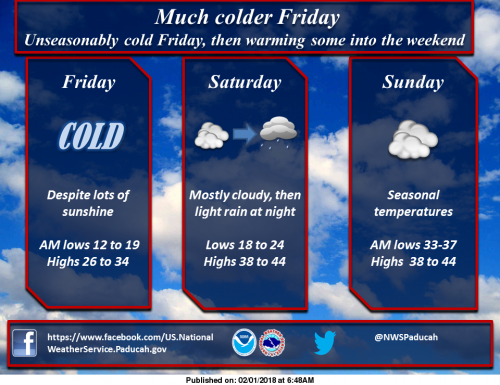
Quite cold conditions coming for Friday, but things should warm just enough Sat in time for some light rains Sat night, especially Western KY. (NWS Paducah)
Special Weather Statement
Light precipitation falling this afternoon may pose a hazard early this evening, as temperatures plummet below freezing. A swath of rain changing to snow produced a dusting for some, mainly from southern Illinois into southwest Indiana and northwest Kentucky. This was mainly on grassy surfaces.
Elsewhere lesser amounts occurred, but all of it got on area roadways, and if they remain wet as temperatures drop, do not be surprised to see some slick spots develop. This will be especially true for bridges and overpasses, and for a few hours after nightfall, when temperatures will quickly be below freezing. Winds will quickly dry things out overnight, but for a few early evening hours, be careful if traveling and look out for flash freezing of moisture on area roadways, as the cold air is incoming really hard and fast.
Hazardous Weather Outlook
.DAY ONE…This Afternoon and Tonight Light precipitation in the form of light rain or light snow, will be followed by temperatures falling below freezing fairly quickly after the precipitation ends. This will potentially create an icing hazard on area roadways, particularly after nightfall early this evening, before the precipitation on the ground is dried up by cold north winds. Be especially cautious on bridges and overpasses. .
DAYS TWO THROUGH SEVEN…Friday through Wednesday Wind chills may be at or slightly below zero early Friday morning. A wintry mix of precipitation is possible late Monday night into early Tuesday, which may result in impacts to travel. Minor accumulations of snow may occur Tuesday night as a low pressure system departs. .
SPOTTER INFORMATION STATEMENT… Spotter activation will not be needed.


Speak Your Mind
You must be logged in to post a comment.