A possible round of wintry weather this weekend….high near 50 on Friday

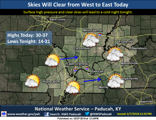
The combination of some sunshine and temperatures climbing above freezing in most locations should allow the ice to melt over most of the region today. Any residual moisture left on roads, parking lots and sidewalks at the end of the day will likely freeze again tonight as temperatures plummet into the teens. (NWS Paducah)

At this time models are all over the place for the timing and amounts.  Right now my gut feeling is that it will not be a major winter storm, but it is something to keep an eye on.  A high around 50 on Friday looks very good  -sd

Hazardous Weather Outlook

.DAY ONE…Today and Tonight In the wake of the winter precipitation last night, residual slick spots will continue on untreated surfaces. .

DAYS TWO THROUGH SEVEN…Thursday through Tuesday A chance of wintry precipitation is forecast for most of the region Saturday night and Sunday. Minor accumulations will be possible. .

SPOTTER INFORMATION STATEMENT… Spotter activation will not be needed.

Seven Day Forecast

This Afternoon 
Sunny, with a high near 32. North northwest wind 8 to 11 mph.
Tonight
Mostly clear, with a low around 16. North northwest wind 5 to 7 mph becoming calm in the evening.
Thursday
Mostly sunny, with a high near 40. Calm wind becoming south 5 to 8 mph in the morning.
Thursday Night
Mostly cloudy, with a low around 30. South wind around 7 mph.
Friday
Partly sunny, with a high near 50. South southwest wind 7 to 10 mph.
Friday Night
Mostly cloudy, with a low around 32. South wind 5 to 7 mph becoming light and variable after midnight.
Saturday
A chance of freezing rain before 7am, then a chance of rain. Cloudy, with a high near 43. North northeast wind 3 to 8 mph. Chance of precipitation is 30%.
Saturday Night
A chance of rain before 9pm, then a chance of rain and snow between 9pm and 10pm, then a chance of snow after 10pm. Cloudy, with a low around 25. North wind around 9 mph.
Sunday
A chance of snow. Partly sunny, with a high near 32. North northwest wind 8 to 10 mph.
Sunday Night
Partly cloudy, with a low around 19. North northwest wind 6 to 8 mph becoming northeast after midnight.
Monday
Mostly sunny, with a high near 42. East northeast wind around 7 mph becoming south southeast in the afternoon.
Monday Night
Partly cloudy, with a low around 31. South wind around 7 mph.
Tuesday
A chance of rain and snow showers. Partly sunny, with a high near 50. South southwest wind 6 to 8 mph.


Speak Your Mind

Benton, West Frankfort, Illinois News | Franklin County News