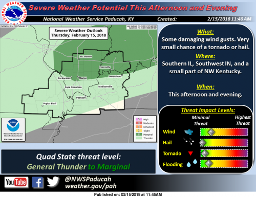
The Storm Prediction Center in Norman Oklahoma has raised part of the Quad State region to a Marginal Risk of Severe Thunderstorms this afternoon and through this evening. The Marginal Risk area is along and north of a line from Owensboro Kentucky to Goreville and Chester Illinois. A broken line of showers, along with widely scattered to scattered thunderstorms is expected develop this afternoon over parts of southern Illinois along and north of the Interstate 64 corridor. A few of these storms could produce damaging wind gusts, especially in and near small bowing clusters of storms. In addition, a small and brief tornado cannot be ruled out through early this evening along a slowly approaching cold front. Small hail is also possible with a few of the storms. With existing river flooding, the rain associated with the cold front will only aggravate minor flooding that is occurring on some river systems in the Quad State region.
Special Weather Statement
…Strong Gusty Winds This Afternoon… While winds will average 15 to 30 mph out of the south or southwest this afternon, some isolated gusts to as high as 40 or 45 mph are a possibility. These strong winds and gusts will continue into early this evening, before diminishing off their peaks.
Expect these strong winds to impact area travel and outdoor work, so be advised, especially if driving a high profile vehicle. Also on area lakes, the southern orientation of the wind will create especially choppy wave heights for north to south running lakes, like Barkely and Kentucky, as well as all bodies of water, rivers and lakes.
Hazardous Weather Outlook
.DAY ONE…This Afternoon and Tonight There is a marginal risk of severe thunderstorms from mid afternoon to early this evening, mainly along and north of a line from Carbondale, Illinois, to Owensboro, Kentucky.
If a storm develops and becomes severe, damaging winds, is the primary severe weather hazard anticipated, although small hail is also possible. An isolated tornado would not be out of the question.
Otherwise, thunderstorms are forecast for the area in entirety through tonight, with locally heavy rainfall the primary storm related hazard. In addition, south to southwest wind speeds will average 15 to 30 mph this afternoon, and may gust up to 40 mph at times, until early evening. Flooding is occurring along the Green and Ohio rivers. Refer to those warnings and statements for details.
.DAYS TWO THROUGH SEVEN…Friday through Wednesday Light snow, possibly mixed with a little sleet and freezing rain, is expected Saturday morning. A dusting to a couple of tenths of an inch of snow is possible mainly in southeast Missouri and southern Illinois, but any accumulations should melt by early afternoon.
A prolonged period of wet weather is forecast to set up over the Ohio and Mississippi River Valleys next week. As such, the potential for flooding will need to be monitored in the coming days as we gain a better idea of where and exactly how much rainfall may occur. There is a chance of thunderstorms from Monday night into Tuesday night. Severe weather is not anticipated. Flooding is forecast to continue along the Green and Ohio rivers. Refer to those warnings and statements for details.
.SPOTTER INFORMATION STATEMENT… Spotters should maintain alert status and monitor the latest forecasts for any updated information.


Speak Your Mind
You must be logged in to post a comment.