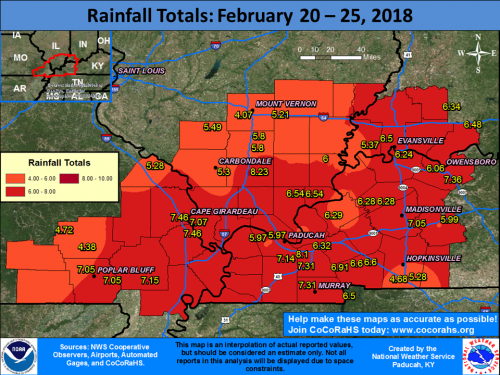
PADUCAH, KY – Multiple waves of precipitation moved through our region from the evening of February 20th through the morning of February 24th. A warm front lifted across the region on Saturday afternoon, followed by a cold front that quickly moved through during the late afternoon and evening hours. Severe thunderstorms accompanied this system with damaging winds and a few tornadoes, including two EF-2 tornadoes that occurred in the Hopkinsville, KY and Matthews, MO areas. Please note that damage surveys are still ongoing with this event! There was also widespread flooding across our area due to 5 to 8 inches of rain falling over a 4 to 5 day period. Flash flood warnings were in effect for the vast majority of the region late Saturday afternoon and evening.
Please click on the link for an interactive web page from the National Weather Service of Paducah Ky.
http://www.weather.gov/pah/2018_Feb24_EventSummary


Speak Your Mind
You must be logged in to post a comment.