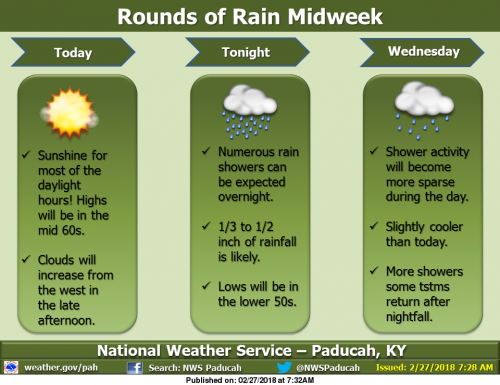
We will have one more mild day with sunshine today, with a southerly breeze, though clouds will increase from the west in the late afternoon. As a disturbance aloft moves across the region, showers are expected primarily after midnight tonight, amounting to less than an inch of rainfall. Clouds will remain Wednesday, with fewer showers around. Wednesday night, rain is expected to return with a vengeance, especially south of the Ohio River, as a low pressure system rolls by just to the north. Some thunderstorms are possible in the northern half of the region. Low lying and flood prone areas could have water issues. (NWS Paducah)
Flood Warning Continues on the Big Muddy Until Thursday
…The flood warning continues for the following rivers in
Illinois…
Big Muddy River near Plumfield
Big Muddy River near Murphysboro
.Flooding continues along the Big Muddy River. The river will crest
at Plumfield tonight at 23.2 feet and fall below flood stage on
Thursday morning. At Murphysboro the river will rise to moderate
flood stage tonight and crest at 30.5 feet Wednesday morning.
PRECAUTIONARY/PREPAREDNESS ACTIONS…
SAFETY MESSAGE…
Never drive cars…trucks or sport utility vehicles through flooded
areas. The water may be too deep to allow safe passage. Never allow
children to play in or near flood waters. Stay tuned to NOAA Weather
Radio or your local media for further statements and possible updated
forecasts.
Hazardous Weather Outlook
.DAY ONE…Today and Tonight
A 1/3 to 1/2 inch of rainfall is forecast across the region
tonight.
Numerous river flood warnings remain in effect. Please refer to
the warning products and their follow up statements for details.
.DAYS TWO THROUGH SEVEN…Wednesday through Monday
Additional rainfall of 1/3 inch northwest to 1 1/3 inch southeast
is forecast across the region during the Wednesday through
Thursday time frame. A chance of thunderstorms forecast for the
northern half of the region on Wednesday night will heighten the
risk for locally heavy rainfall amounts there. Refer to the
Hydrologic Outlook for more detailed information on this mid week
rain chance and its potential impacts.
Windy conditions are likely on Thursday behind a cold front.
Northwest winds could gust 30 to 40 mph at times.
A slight chance of thunderstorms is forecast for the entire region
Monday. Locally heavy rainfall will be the primary concern.
River flood warnings will remain in effect through much of the
week. Refer to the flood warnings and statements for important
river flood details, including the latest updated information.
Hydrologic Outlook
…ONE TO AS MUCH AS TWO INCHES OF RAINFALL POSSIBLE…
Another rain event is coming for the middle of this week for the
region. The rain will begin tonight, and will end Thursday.
During that time, we expect average rainfall to total between a
half inch across the northwestern tier of counties in southeastern
Missouri and southern Illinois, to nearly two inches close to the
Tennessee state line. Locally higher amounts in thunderstorms,
which are forecast for Wednesday night in the northern half of the
region, could cause rainfall totals to reach into the 1 to 2 inch
range there by the end of the day Thursday.
This amount of rainfall would not normally cause many issues.
However, given the still wet ground conditions from last week`s
rains, and the forecasted crests of river stages, you should
monitor local water conditions closely as this next rain occurs.
Low lands and poorer drainage areas may flood more quickly than
usual. This may extend ponding or flooding of water overtop back
country roads, especially ones near creeks and streams that may
swell more quickly than usual.
Stay tuned to all the latest forecasts and updates and keep an eye
for rising waters as rains hit during the mid week period.
Seven Day Forecast


Speak Your Mind
You must be logged in to post a comment.