After a brief break in the heavier rains earlier this morning, another round of rain is expected this afternoon. Hourly rainfall accumulations will be one tenth inch or less, unless an isolated thunderstorm passes overhead. Please be cautious today. (NWS-Paducah)
Flood Warning still in effect for the Big Muddy until Friday
…The flood warning continues for the Big Muddy River affecting areas in southern Illinois… Near Plumfield affecting Franklin and Williamson Counties Near Murphysboro affecting Jackson County .
The Big Muddy River near Plumfield is receding at this time with flood conditions expected to end late tomorrow. Near Murphysboro, the river is cresting at this time, with flood conditions forecast to end early next week.
PRECAUTIONARY/PREPAREDNESS ACTIONS… SAFETY MESSAGE… Never drive cars…trucks or sport utility vehicles through flooded areas. The water may be too deep to allow safe passage. Never allow children to play in or near flood waters. Stay tuned to NOAA Weather Radio or your local media for further statements and possible updated forecasts.
Hazardous Weather Outlook
DAY ONE...Today and Tonight

Isolated thunderstorms are possible this morning, mainly in
southeastern Missouri and southwestern Illinois. Isolated
thunderstorms are also possible north of I-64 tonight.

Rainfall totals of up to an inch and a half are possible through
tonight. Please refer to the Hydrologic Outlook for details.

Numerous river flood warnings remain in effect. Refer to the
warning products and their follow up statements for details.

.DAYS TWO THROUGH SEVEN...Thursday through Tuesday

Northwesterly winds behind a cold front Thursday afternoon are
expected to gust 25 to 35 mph, and possibly as high as 40 mph.

River flood warnings will remain in effect through much of the
week. Refer to the flood warnings and follow up statements for
details.

.SPOTTER INFORMATION STATEMENT...

Spotter activation is not anticipated.
Hydrologic Outlook
…UP TO ONE AND A HALF INCHES OF RAINFALL POSSIBLE…
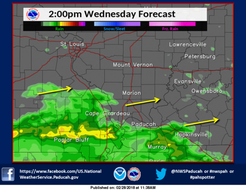
As a low pressure system approaches, and eventually moves through the region, rainfall is expected to occur in two rounds. The first round will be early today, and the second tonight and early Thursday. Total rainfall amounts of around an inch are expected over most of southeastern Illinois, most of western Kentucky, and extreme eastern Missouri, with lesser amounts elsewhere. The only exception to this will be locations near the TN border, where up to an inch and a half is possible.
This amount of rainfall would not normally cause many water issues. However, given the wet ground conditions from last week`s rains, and high river and creek levels in many areas, you should monitor local water conditions closely. Low lying and poor drainage areas may flood more quickly than usual, and this could result in flooding of some roadways, especially ones near areas that have this flooding tendency.
Stay tuned to all the latest forecasts and updates and keep an eye out for rising waters.
Seven Day Forecast


Speak Your Mind
You must be logged in to post a comment.