IDOT worker was hit while pothole patching in Jacksonville Monday

From the Illinois Department of Transportation 

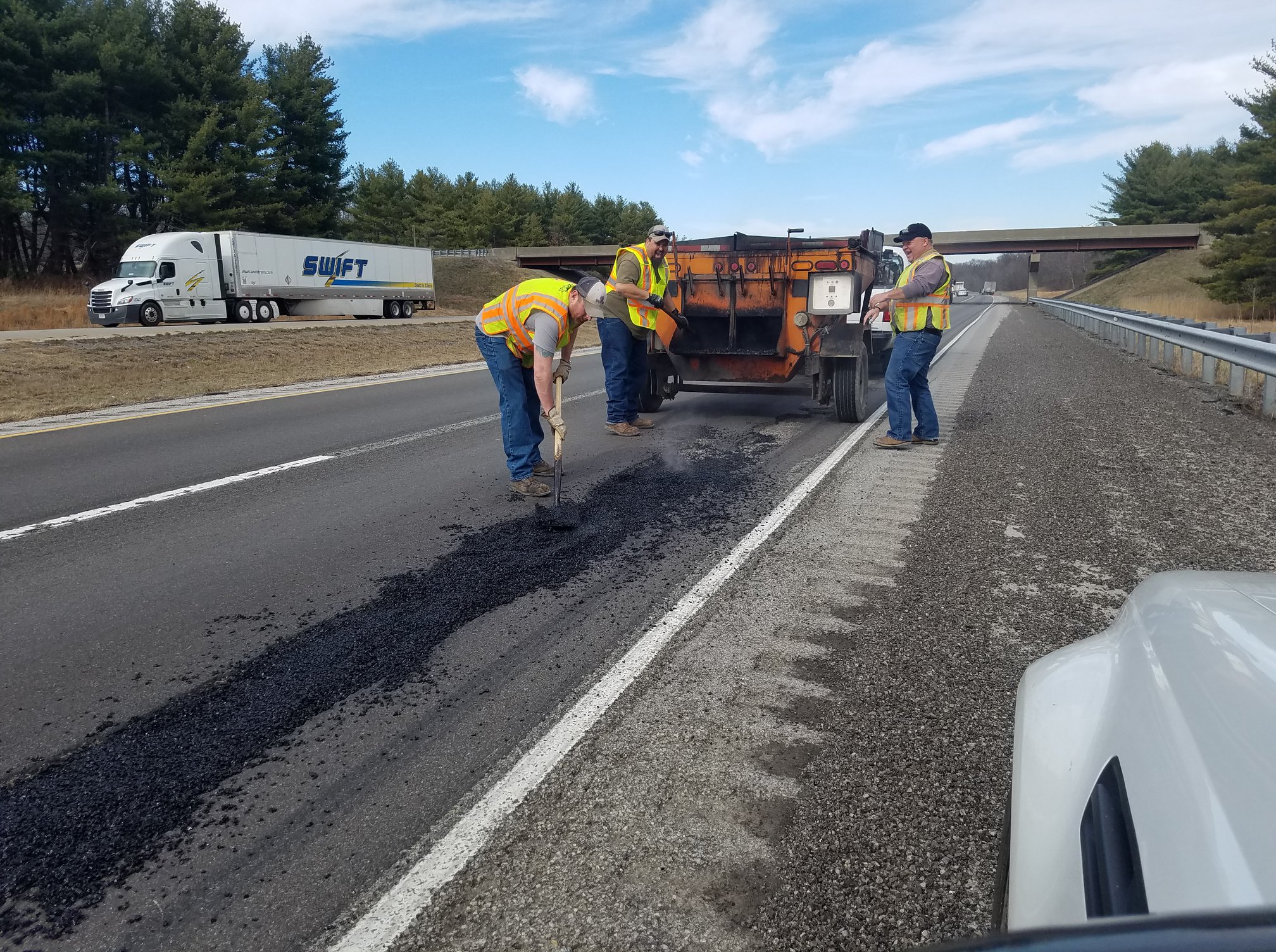
JACKSONVILLE – The Illinois Department of Transportation employee who was part of a crew patching potholes on Morton Avenue in Jacksonville when he was struck by another vehicle is in critical condition at a local hospital.

We continue to cooperate with Illinois State Police in their investigation.

Yesterday’s tragic incident is yet another sad, unfortunate reminder of the dangers of working and traveling in work zones. We strongly urge the public to remain alert at all times, avoid distractions, slow down and proceed with extreme caution when approaching workers out in the field. In Illinois, motorists are required to change lanes, if possible, and provide extra distance between them and workers, first responders and disabled vehicles. It’s the law.

ROAD CLOSURE: State Route 142 on the east end of Mt. Vernon

From the Jefferson County EMA 

Mt. Vernon –  PAY CLOSE ATTENTION TO THIS IF YOU WORK AT CONTINENTAL TIRE.

Be advised that State  Route 142 is currently closed at the railroad tracks on the east side of Mt. Vernon for railroad crossing construction. Please allow extra travel time and use marked detours.

Sen. Fowler provides update from IDOT on traffic signal in Harrisburg

HARRISBURG – State Senator Dale Fowler (R-Harrisburg) is providing an update on ongoing efforts to bring a stoplight to the accident-prone intersection of Route 13 and Poplar Street in Harrisburg, which was the scene of another traffic accident last week.

“This intersection has been the scene of numerous crashes over the years, underscoring the importance of taking steps to make the intersection safer for motorists,” said Sen. Fowler. “A stoplight will go a long way toward helping to improve road safety for the community and reducing the number of accidents at the busy crossroad.”

Sen. Fowler said the Illinois Department of Transportation (IDOT), in conjunction with the City of Harrisburg, will be installing traffic signals at the intersection of Illinois 13 and West Poplar Street (Old Illinois 13) on the west side of Harrisburg.

Sen. Fowler has worked with IDOT to conduct a traffic analysis on the ongoing safety concerns of the busy intersection, and is optimistic to see light at the end of the tunnel for this longstanding project.

“This was an issue that was brought to my attention when I was serving at the local level, and to be able to share progress on this project is encouraging. The safety of our community has to be paramount and bringing a stoplight to the area gives our motorists some measure of safety when they approach the intersection,” said Sen. Fowler.

Sen. Fowler says he hopes the traffic signal will help improve roadway safety at the intersection, as well as improve access to the area.

“I’m optimistic that this stoplight will help vehicles traverse the area better, allowing for better traffic flow and improving the possibilities of economic development along the roadway,” said Sen. Fowler. “Right now, gaining access through the intersection is difficult and sometimes dangerous. I hope this traffic signal will have the added benefit of enabling vehicles to get in and out of the area easier and encourage some business development as safety and organization is brought to the junction.”

According to IDOT, in January the state received bids from contractors to install the traffic signals. The low bid contractor was Brown Electric and a contract for $228,250 has been awarded to install traffic signals, pavement markings and concrete shoulders. The contract is in the process of being executed, work should begin this summer, and the new traffic signals should be in operation by the fall of 2018.

As the project continues into development, IDOT would like to remind motorists that traffic signals are not a solution for all traffic problems, urging motorists to obey the speed limit, always be alert and avoid distractions.

Sen. Fowler echoes their call for drivers to continue to be alert, follow the rules of the road and help keep the roadways as safe as possible for all motorists.

Enjoy this nice day……showers moving into the area starting tonight

We will have one more mild day with sunshine today, with a southerly breeze, though clouds will increase from the west in the late afternoon. As a disturbance aloft moves across the region, showers are expected primarily after midnight tonight, amounting to less than an inch of rainfall. Clouds will remain Wednesday, with fewer showers around. Wednesday night, rain is expected to return with a vengeance, especially south of the Ohio River, as a low pressure system rolls by just to the north. Some thunderstorms are possible in the northern half of the region. Low lying and flood prone areas could have water issues. (NWS Paducah)

Flood Warning Continues on the Big Muddy Until Thursday

…The flood warning continues for the following rivers in
Illinois…

Big Muddy River near Plumfield
Big Muddy River near Murphysboro

.Flooding continues along the Big Muddy River. The river will crest
at Plumfield tonight at 23.2 feet and fall below flood stage on
Thursday morning. At Murphysboro the river will rise to moderate
flood stage tonight and crest at 30.5 feet Wednesday morning.

PRECAUTIONARY/PREPAREDNESS ACTIONS…

SAFETY MESSAGE…

Never drive cars…trucks or sport utility vehicles through flooded
areas. The water may be too deep to allow safe passage. Never allow
children to play in or near flood waters. Stay tuned to NOAA Weather
Radio or your local media for further statements and possible updated
forecasts.

Hazardous Weather Outlook

.DAY ONE…Today and Tonight

A 1/3 to 1/2 inch of rainfall is forecast across the region
tonight.

Numerous river flood warnings remain in effect. Please refer to
the warning products and their follow up statements for details.

.DAYS TWO THROUGH SEVEN…Wednesday through Monday

Additional rainfall of 1/3 inch northwest to 1 1/3 inch southeast
is forecast across the region during the Wednesday through
Thursday time frame. A chance of thunderstorms forecast for the
northern half of the region on Wednesday night will heighten the
risk for locally heavy rainfall amounts there. Refer to the
Hydrologic Outlook for more detailed information on this mid week
rain chance and its potential impacts.

Windy conditions are likely on Thursday behind a cold front.
Northwest winds could gust 30 to 40 mph at times.

A slight chance of thunderstorms is forecast for the entire region
Monday. Locally heavy rainfall will be the primary concern.

River flood warnings will remain in effect through much of the
week. Refer to the flood warnings and statements for important
river flood details, including the latest updated information.

Hydrologic Outlook

…ONE TO AS MUCH AS TWO INCHES OF RAINFALL POSSIBLE…

Another rain event is coming for the middle of this week for the
region. The rain will begin tonight, and will end Thursday.
During that time, we expect average rainfall to total between a
half inch across the northwestern tier of counties in southeastern
Missouri and southern Illinois, to nearly two inches close to the
Tennessee state line. Locally higher amounts in thunderstorms,
which are forecast for Wednesday night in the northern half of the
region, could cause rainfall totals to reach into the 1 to 2 inch
range there by the end of the day Thursday.

This amount of rainfall would not normally cause many issues.
However, given the still wet ground conditions from last week`s
rains, and the forecasted crests of river stages, you should
monitor local water conditions closely as this next rain occurs.
Low lands and poorer drainage areas may flood more quickly than
usual. This may extend ponding or flooding of water overtop back
country roads, especially ones near creeks and streams that may
swell more quickly than usual.

Stay tuned to all the latest forecasts and updates and keep an eye
for rising waters as rains hit during the mid week period.

Seven Day Forecast

Today
Increasing clouds, with a high near 65. South wind 6 to 14 mph, with gusts as high as 20 mph.
Tonight
Showers, mainly after midnight. Low around 50. South wind 7 to 10 mph. Chance of precipitation is 90%.
Wednesday
Showers likely, mainly before noon. Patchy fog after noon. Otherwise, cloudy, with a high near 62. East southeast wind around 7 mph becoming south southwest in the afternoon. Chance of precipitation is 60%.
Wednesday Night
Showers likely, with thunderstorms also possible after midnight. Cloudy, with a low around 49. South wind 6 to 10 mph, with gusts as high as 18 mph. Chance of precipitation is 70%.
Thursday
A 40 percent chance of showers before noon. Partly sunny, with a high near 54. Breezy, with a west southwest wind 11 to 20 mph becoming northwest in the afternoon. Winds could gust as high as 33 mph.
Thursday Night
Mostly clear, with a low around 32. North northwest wind 8 to 15 mph, with gusts as high as 25 mph.
Friday
Sunny, with a high near 50. North northeast wind 5 to 8 mph.
Friday Night
Clear, with a low around 31. East northeast wind around 6 mph.
Saturday
Sunny, with a high near 54. East southeast wind 5 to 7 mph.
Saturday Night
Clear, with a low around 34. East wind around 7 mph.
Sunday
Sunny, with a high near 57. Southeast wind around 8 mph.
Sunday Night
A chance of showers. Mostly cloudy, with a low around 42. Southeast wind around 9 mph.
Monday
A chance of showers and thunderstorms. Mostly cloudy, with a high near 54. South wind around 10 mph becoming west northwest in the afternoon.


Franklin County EMA programming NOAA Weather Radios at Benton/West City Walmart

WEST CITY –  Join the Franklin County Emergency Management Agency, West City Fire Department during Severe Weather Preparedness Week for a FREE NOAA All-Hazards Radio Programming Event.  This will take place at the West City Walmart on Monday, March 5th between 8:00-4:00 p.m.

Please bring your radio by or purchase one at Walmart and we will program your radio to ensure you are weather ready!

Also, FCEMA will take part in basic storm spotter training that evening in West City.  Details will be coming soon. -sd

February 24, 2018 Severe Weather and Flooding Summary


PADUCAH, KY – Multiple waves of precipitation moved through our region from the evening of February 20th through the morning of February 24th. A warm front lifted across the region on Saturday afternoon, followed by a cold front that quickly moved through during the late afternoon and evening hours. Severe thunderstorms accompanied this system with damaging winds and a few tornadoes, including two EF-2 tornadoes that occurred in the Hopkinsville, KY and Matthews, MO areas. Please note that damage surveys are still ongoing with this event! There was also widespread flooding across our area due to 5 to 8 inches of rain falling over a 4 to 5 day period. Flash flood warnings were in effect for the vast majority of the region late Saturday afternoon and evening.

Please click on the link for an interactive web page from the National Weather Service of Paducah Ky.

http://www.weather.gov/pah/2018_Feb24_EventSummary

Janus vs. AFSCME to be heard today by the U.S. Supreme Court

AP file photo

WASHINGTON, DC – Nerves are on edge today for an Illinois state employee challenging a public sector union over forced fees that workers have to pay the union as a condition of employment.

The case Janus vs. AFSCME, which originated in Illinois, will be heard this morning in front of the U.S. Supreme Court.

Mark Janus, the state government employee at the center of the case, said he’s nervous.

“But what I think is important to note is that there is just as much right to say ‘no’ to a union as there is to say ‘yes’ to a union,” Janus said. “And that is a right that I don’t have [under the status quo].”

Please click on the link for the full story from Greg Bishop of Illinois News Network

https://www.ilnews.org/news/justice/janus-vs-afscme-to-be-heard-today-by-the-u/article_9c857c2c-18e2-11e8-84d7-73114056dd15.html

Illinois Proud: Brett Eldredge To Headline 2018 Illinois State Fair

Edgar County Native, Country Music Superstar’s First Performance on Grandstand Stage

SPRINGFIELD, IL -A native of Paris, Illinois, Brett Eldredge, will headline the Illinois State Fair Grandstand on Friday, August 17.  His Illinois roots run deep as his second album is titled Illinois and he has videos set in his hometown and Wrigley Field.  This powerhouse country star is sure to entertain concertgoers with his fun-loving, hilarious, yet sensitive personality.

“The Illinois State Fair is eager to host Brett Eldredge,” says Luke Sailer, Acting State Fair Manager. “We are proud to have an Illinois native on the grandstand stage, especially in 2018, Illinois’ bicentennial year.”

His current album, aptly self-titled, Brett Eldredge shows the different sides of Eldredge and reflects where he is in life right now.  The album includes upbeat songs such as “Somethin’ I’m Good At,” and “Superhero,” to meaningful ballads including, “The Long Way,” and “Brother,” all of which Eldredge is a co-writer.

This album is sure to follow the success of his first two albums, Bring You Back and Illinois, which combined to give him six #1 singles in row. Those include “Don’t Ya,” Lose My Mind,” and “Wanna Be That Song.” Building on the success of his 2014 win for CMA New Artist of the Year, Eldredge has been nominated for various other awards and co-hosted ABC’s CMA Music Festival: Country’s Night to Rock and was featured on “Forever Country,” a medley performed by a group of 30 different country artists.

An opening act for Brett Eldredge will be announced at a later date.  Tickets will go on sale later this spring.

Mark your calendars for the 2018 Illinois State Fair, August 9th – 19th, in Springfield, IL.

Stay up to date with all the latest news and announcements from the Illinois State Fair by connecting with us via FacebookTwitter and Instagram.

Illinois State Police warns drivers to watch out for potholes

From the Illinois State Police- District 13

DU QUOIN – Sure! It’s beautiful out now, but yesterday’s rains left a little present for roadway users. Nasty little things, they are! They will tear up your cars, flatten your tires, and knock your front end out of alignment.

Illinois State Police photo

It’s an unfortunate consequence of water. One of the most powerful forces of nature, moving water is capable of ripping large holes in pavement like it was a Kleenex. Avoid moving the water in those puddles. It’ll tear up your car…

Increase your following distance to the car in front of you. It gives you more time to react. Look for the holes instead of at your phone. Can’t see them if you’re checking social media or texts 

Hope you enjoyed this humorous look at a common problem this time of year. #GiveEmaBrake as IDOT patches holes this time of year!

Severe storms, possible tornadoes rip through Southern Kentucky

WHOP radio in Hopkinsville KY image.

HOPKINSVILLE – KY – Severe storms killed at least one person, injured several others and caused destruction Saturday evening across Southern Kentucky.

Christian County Emergency Management Director Randy Graham told WHOP that a possible tornado injured 9 people at Eagle Crossing Apartments.

Graham said 6 people were treated on the scene for minor injuries while three other people were taken to an area hospital for treatment of injuries not believed to be life-threatening.

Please click on the link for the story from WKRN-TV in Nashville, TN.  WHOP radio from Hopkinsville added to this story.

Severe storms, possible tornadoes rip through Southern Kentucky


Benton, West Frankfort, Illinois News | Franklin County News