BARN FIRE ON EAKIN GROVE CHURCH ROAD

by Steve Dunford

WSIL-TV photo

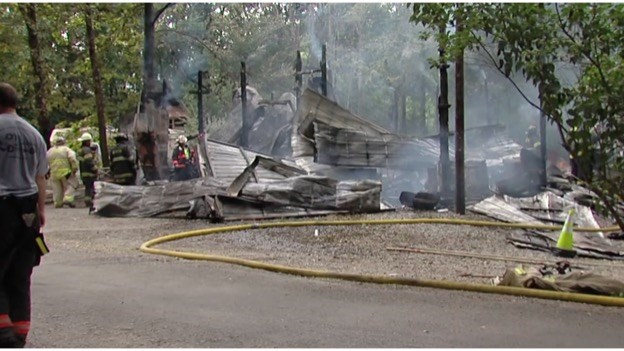
At 2:02 pm, West City firefighters were toned to the scene of a barn fire on 10641 Eakin Grove Church road, with heavy fire and several explosions.  This was located just west of the former Eakin Grove Church.

The structure was a total loss, with $200,000 of estimated damage.  The cause of the fire, was a shorted out battery charger.

Benton, Ewing-Northern, Buckner, and Zeigler fire departments provided mutual aid.

Story information from WSIL-TV, Southern Illinois Fire Incidents, and Southern Illinois fire dispatch.  Below is a link to the News 3 story and video.

http://www.wsiltv.com/story/36070807/barn-destroyed-by-fire-in-franklin-county


Benton #47 Superintendent eyes cash reserves in lieu of state funds

http://www.bentongazette.com/news/superintendent-eyes-cash-reserves-in-lieu-of-state-funds/article_0330d52a-7983-11e7-8cff-73986875c3d2.html

BENTON, IL –  (Tim Hastings, Benton Gazette.  Please click on the link above for the full story.  Here is an excerpt below)

– Benton Grade School District 47 Superintendent Stephen Smith told the board of education Tuesday, July 25, the district would have to dip into its cash reserves if the legislature is unable to pass a school funding plan.

“We might have 60 to 90 days cash on hand to operate without state payment,” Smith said. “After that, we’d have to establish lines of credit in order to borrow operating funds. Half of the district’s funds come from the state. Operating very long without that isn’t viable.

State Representative Dave Severin, whom the board recognized Tuesday for serving 30 years as a member of the board, said he favors Illinois Senate Bill 1 which would give District 47 approximately $527,000 in new funds next year. However, Severin said he opposes an amendment to the bill which would fund teachers’ pensions in Chicago. “SB 1 is a great bill except for the amendment,” Severin said.  The representative said he would also like the state to pay the $307,000 it owes the district for the current year.

Wet and stormy Sunday….mild conditions for the rest of the week

Expect showers at times today and tonight. Scattered thunderstorms will occur, mainly in the afternoon and evening. A few severe storms cannot be ruled out south of a line from Carbondale to Evansville, including most of southeast Missouri. The activity will diminish after midnight. Total rainfall will average from one-half to one inch.

Hazardous Weather Outlook
National Weather Service Paducah KY
415 AM CDT Sun Aug 6 2017

.DAY ONE…Today and Tonight

There is a marginal risk of severe thunderstorms, mainly this
afternoon and evening. Damaging winds is the primary severe
weather hazard, but most storms will see heavy rain and lightning
as the primary hazards.

.DAYS TWO THROUGH SEVEN…Monday through Saturday

Storm chances that exist during this time period will see heavy
rain and lightning as the primary hazards.

.SPOTTER INFORMATION STATEMENT…

Spotter activation is not anticipated at this time.

Detailed Forecast

weather.gov
Today
Showers and thunderstorms likely, mainly after 1pm. Cloudy, with a high near 76. North wind 5 to 8 mph becoming east southeast in the morning. Chance of precipitation is 70%.
Tonight
Showers and thunderstorms likely, mainly before 1am. Cloudy, with a low around 66. East southeast wind 5 to 7 mph becoming light and variable after midnight. Chance of precipitation is 70%.
Monday
A 20 percent chance of showers and thunderstorms before 1pm. Mostly cloudy, with a high near 80. North wind around 7 mph.
Monday Night
Mostly cloudy, with a low around 62. North northeast wind 3 to 6 mph.
Tuesday
Mostly sunny, with a high near 81. Northeast wind 5 to 7 mph.
Tuesday Night
Partly cloudy, with a low around 63. Northeast wind around 5 mph.
Wednesday
Mostly sunny, with a high near 83. East northeast wind 3 to 6 mph.
Wednesday Night
Partly cloudy, with a low around 65. East northeast wind 3 to 5 mph.
Thursday
Partly sunny, with a high near 85. Light north northeast wind.
Thursday Night
Partly cloudy, with a low around 66. Light northeast wind.
Friday
A slight chance of showers and thunderstorms. Partly sunny, with a high near 86. North northeast wind 3 to 5 mph.
Friday Night
A chance of showers and thunderstorms. Mostly cloudy, with a low around 68. South wind 3 to 5 mph.
Saturday
A chance of showers and thunderstorms. Mostly cloudy, with a high near 85. Southwest wind 3 to 6 mph.

Crab Orchard Wildlife Refuge open for solar eclipse viewing

http://www.kfvs12.com/story/36068374/marion-refuge-open-for-solar-eclipse-viewing

MARION, IL – (Kaylee Ross, KFVS-TV.)  Please click on the link for the full story.  Here is an excerpt below.

The entirety of the Crab Orchard National Wildlife Refuge will fall under the path for the majority of the August 21st solar eclipse.

A large number of eclipse viewers are expected during the already busy camping season.

The Wolf Creek Causeway crossing Crab Orchard Lake and the Little Grassy Lake overlook on Grassy Road will be closed to motorized vehicles starting Sunday, August 20 afternoon.

Fatalities most common on rural roads in southern Illinois, IDOT data shows

http://www.wsiltv.com/story/36068087/fatalities-most-common-on-rural-roads-in-southern-illinois-idot-data-shows

CARBONDALE, IL (Tia, Rineheart, WSIL-TV.  Please Click on the link for the full story and video, here is an excerpt below.)

If you live in the rural parts of southern Illinois, driving the narrow, dark back roads probably feels like routine.

Dianna Yates has lived in rural Cobden for 30 years and says she’s mastered driving on rural roads.
“I live on a country road, Aldrich Road here in Cobden, and it’s an up and down road, so I always anticipate what’s ahead of me, what’s coming over the next hill,” she said.

But not everyone is as aware on those back roads. The most recent data from IDOT shows that in 2015, while hundreds of traffic accidents happen on all roads, nearly all traffic fatalities in our area happened on a rural road.

In Franklin County, out of 12 fatalities, all but one were on rural roads.

FOWLER COMMENTS ON SB1, CO-HOSTS TRUCKER’S ROUNDTABLE

Week in Review from State Senator Dale Fowler

HARRISBURG, IL – After a two-month delay by the Senate Majority on sending the education funding formula to the Governor, State Sen. Dale Fowler (R-Harrisburg) said a recent amendatory veto was the only course of action to a politician-created crisis.

The Governor took swift action on August 1, to amendatorily veto Senate Bill 1, the new education funding formula. Senator Fowler insists that the Senate Majority needs to return to the bargaining table to finish working on the education funding formula before schools open in two weeks.

Sadly, the clock continues to tick on a the eve of a new school year, which has prompted several area superintendents to question how long they are able to keep their district’s doors open without state funds.

Fowler co-hosts trucking roundtable

Senator Fowler joined with the Illinois Truckers Association on August 2 to discuss issues facing the Illinois trucking industry. The Senator met with representatives of more than a dozen local trucking firms to get a sense of the economic impact of the logistics industry. Several topics were discussed like: fuel blending taxation, fees, permits, and licensing.  A special emphasis was given on trucking and motorist safety as a result of the recent double-digit increase in the number of accidents and fatalities on Interstates 57 and 24 in rural Southern Illinois.

JULY CLIMATE SUMMARY – PADUCAH NATIONAL WEATHER SERVICE

From the National Weather Service Paducah KY

http://www.weather.gov/pah/July2017ClimateSummary

Above is an interactive link to several statistics and graphics from the National Weather service in Paducah KY.  Below is an introductory statement summarizing the month of July’s weather.

July 2017 Climate Summary: Temperatures were mostly 1 to 2 degrees above normal while precipitation was generally below normal across a good portion of the region. The main exception was across southwest Indiana and part of southern Illinois closer to the I-64 corridor.  Near to above normal rainfall fell across much of White and Hamilton Counties in Illinois into southwest Indiana. The highest observed rainfall total was in Pike County Indiana at the Stendal COOP Station where 10.49” occurred. Many locations only picked up 1.5 to 3 inches for the month, which is roughly 1 to 2 inches below normal for July. As is typically the case in the warmer months, thunderstorms cause rainfall to be distributed very unevenly. A clear example of this is in Pike County Indiana where a station observed only 2.13” in the northern part of the county compared to the 10.49” in Stendal in the southeast part of the county. There were also locations where there are no reporting stations, but radar estimates showed fairly heavy amounts occurred. An example of this is in northeast Hamilton County and western White Counties in Illinois where radar estimates showed monthly totals anywhere from 6 to 8 inches, but there is no observation station in that area to measure it. This is a prime example of why we need as many observers as possible in every county to measure precipitation.

As for temperatures, there weren’t really any prolonged cool stretches, which is typical in July in our region. We experienced the coolest temperatures during the last 3 days of the month when some lows dipped into the mid to upper 50s. The hottest stretch was from July 19th through 22nd when temperatures reached the mid to upper 90s with heat index readings from 100 to 110 common, with some higher readings up near 115, particularly on July 21st. Most of the region was under an Excessive Heat Warning during that time. Paducah, KY observed high temperatures of 89 degrees or warmer for 22 straight days from July 7th through July 28th. July 2017 also marks the 14th consecutive month with temperatures at or above normal in Paducah and Evansville.


TODAY WILL BE VERY NICE AGAIN, STORMY SUNDAY AHEAD


Detailed Forecast

weather.gov
Today
Increasing clouds, with a high near 83. Calm wind becoming south around 6 mph in the morning.
Tonight
A 30 percent chance of showers after 1am. Mostly cloudy, with a low around 64. Light southeast wind.
Sunday
Showers and thunderstorms likely. Cloudy, with a high near 79. Southeast wind 5 to 8 mph. Chance of precipitation is 70%.
Sunday Night
Showers and thunderstorms likely, mainly before 1am. Cloudy, with a low around 66. Southeast wind 5 to 8 mph becoming light and variable in the evening. Chance of precipitation is 60%.
Monday
A 20 percent chance of showers and thunderstorms before 1pm. Mostly cloudy, with a high near 81. North wind 3 to 7 mph.
Monday Night
Mostly cloudy, with a low around 64. North northeast wind 3 to 6 mph.
Tuesday
Mostly sunny, with a high near 82. East northeast wind 5 to 7 mph.
Tuesday Night
Partly cloudy, with a low around 63. East northeast wind 3 to 5 mph.
Wednesday
Partly sunny, with a high near 84. East northeast wind 3 to 5 mph.
Wednesday Night
Partly cloudy, with a low around 64. East northeast wind 3 to 5 mph.
Thursday
Mostly sunny, with a high near 85. North northeast wind 3 to 5 mph.
Thursday Night
Partly cloudy, with a low around 66. Light northeast wind.
Friday
A chance of showers and thunderstorms. Mostly sunny, with a high near 86. East northeast wind 3 to 5 mph.

City to launch weekend project to cut down weeds

http://www.bentongazette.com/news/city-to-launch-weekend-project-to-cut-down-weeds/article_62171456-7716-11e7-9cb2-6ba700fb1b3f.html

BENTON, IL –  (William McPherson, Benton Gazette.  Please click on the link for the full story.  Here is an excerpt below.)

The City of Benton is getting ready to whack down some weeds.

Mayor Fred Kondritz said at Monday’s meeting that after discussing the matter with Street Commissioner Donnie Wyant, that the City will begin having a Street Department employee work an additional four hours every Saturday, weed eating various city owned properties and residential ditches until the city’s overgrowth problem is contained.

 Kondritz and Wyant discussed the matter of residents not maintaining ditches and islands. These pieces of land, although technically belonging to the City, were said to be the resident’s responsibility to maintain according to City ordinances.


Multiple vehicle crash on Interstate 24

http://www.wsiltv.com/story/36064878/multiple-vehicle-crash-on-interstate-24

(WSIL – TV photo)

GOREVILLE, IL –  (Courtney Cruise, WSIL – TV.  Please click on the link for the full story.  Here is an excerpt below.)

ORIGINAL STORY

Emergency crews are on the scene of a multiple-vehicle crash on Interstate 24.’

The crash involves at least eight vehicles with three of them on fire at mile post 2.

UPDATED STORY: AUGUST 04, 2017 1:17 P.M.

JOHNSON COUNTY — The eastbound lanes of Interstate 24 near mile post 2 have reopened.

Traffic is still moving slowly. Authorities ask that drivers avoid the area.


Benton, West Frankfort, Illinois News | Franklin County News