Bost Votes for Bipartisan National Security Funding Bill

from George O’ Connor – Communications Director for Congressman Mike Bost

WASHINGTON – U.S. Representative Mike Bost (R-Murphysboro) voted for the Make America Secure Appropriations Act (H.R. 3219), the legislative package that funds national security priorities for the 2018 fiscal year. It includes the appropriations bills for defense, military construction and veterans, energy and water, and the legislative branch.

“The highest priority of Congress is to ensure the safety and security of our nation and the American people,” said Bost. “This bill does just that by giving our service members a much-deserved pay raise—the largest military pay raise in eight years. It also funds military infrastructure so that our service members can be safe and prepared, and takes care of our vets by providing the highest level of funding ever for the Department of Veterans’ Affairs.  Additionally, the legislation secures our borders by providing funding for a wall on our southern border.”


Major water line break in the City of Benton

by Steve Dunford

There has been a major water line break in the city of Benton, along West Church Street.  Pictures on social media show that part of the street is flooded.  It has been reported that residents in the area of the break are without water, and the Benton Street Department has issued a boil water order until further notice in the area of the break.

At this time the street is closed.  I will pass along further updates as I get them.

Here is a 6:45 p.m. update from KFVS-TV

http://www.kfvs12.com/story/35990243/water-line-break-closes-intersection-in-benton-il-boil-water-order-issued

This is from the City of Benton’s Facebook page

UPDATE: A boil water order is now in effect for all water customers from DuQuoin Street to South Main and from Washington Street to Hudelson. This order will likely be necessary until Tuesday. As a precaution, the order also remains in effect for anyone who has experienced a reduction in their water pressure. Water department crews are currently on scene and drivers should be aware that the intersection of Church and Pope is currently closed. We’ll keep updates coming on the repair progress of the water line and a lift of the order.


Eads Bridge closed as tow trucks respond to tanker truck off overpass

KMOV photo

http://www.kmov.com/story/35984546/tanker-truck-hanging-off-overpass-in-downtown-st-louis

ST. LOUIS, MO  – (KMOV-TV.  Please click on the link for the full story and others regarding this incident.  Here is an excerpt below,)

The Eads Bridge is closed in both directions after a tanker truck crashed off the overpass of eastbound Interstate 44 at Washington in downtown St. Louis. A heavy emergency response was seen just after 7 a.m. Thursday when the truck was found hanging off the overpass.

Following the crash, a News 4 photographer on the scene noted the driver walked himself to a nearby ambulance.


One dead, seven injured after ride malfunctions at Ohio State Fair

http://www.10tv.com/article/1-dead-7-injured-after-ride-malfunctions-ohio-state-fair

Telegraph UK photo

COLUMBUS, OH- One person was killed and other seven were injured after a ride malfunctioned at the Ohio State Fair.

A swinging and spinning amusement park ride called the Fire Ball malfunctioned and broke apart on the opening day of the fair.

Five of the injured were taken to either Wexner Medical Center or Grant Medical Center in critical condition. The remaining injured were taken to local hospitals in stable condition.

Authorities have not identified any of the victims at this time.

Finger-pointing continues as Cullerton says he’ll wait until Monday to send education funding bill to Rauner’s desk

https://www.ilnews.org/news/state_politics/finger-pointing-continues-as-cullerton-says-he-ll-wait-until/article_52118d0e-720f-11e7-a515-3ba5261c8f48.html

SPRINGFIELD, IL – (Greg Bishop and Dan McCaleb, Illinois News Network. Please click on the link above for the full story.  Here is an excerpt below.)

The first day of the latest legislative special session in Springfield boiled down to a “he said-he said” of accusations between Gov. Bruce Rauner and Democratic leaders in the General Assembly, but it did result in some clarity over the legislation at the heart of the dispute.

Senate President John Cullerton said Wednesday he would send a legislatively approved education funding bill to Gov. Bruce Rauner’s desk early next week if he can’t get a face-to-face meeting with the governor before then.

“That’s outrageous,” Rauner countered, noting that the education funding bill in question was approved by lawmakers back in May and should have been sent to his desk by early June.

Panera Bread Commercial filmed in Johnston City debuts

http://www.wsiltv.com/story/35976941/panera-bread-commercial-shot-in-johnston-city-debuts

JOHNSTON CITY, IL – Above is a link to the WSIL story of  of the Panera Bread commercial filmed at the Johnston City Fireworks display.

Severin to Hold Satellite Office Hours in Sesser on August 1st

Press Release for the office of State Representative Dave Severin

MARION, IL –  State Representative Dave Severin (R- Benton) will be holding satellite office hours at Sesser City Hall, 302 W Franklin St, in Sesser from 10:00 am to 1:00 pm on Tuesday August 1st.

Rep. Severin’s staff will be available to meet with constituents to address concerns and receive feedback on the issues most important to them.

If you have any questions, please contact Rep. Severin’s District Office at (618) 440-5090 or through the contact form on his website at www.repseverin.com.


Benton City Council hears about insurance benefit program

http://www.bentoneveningnews.com/news/20170726/benton-city-council-hears-about-insurance-benefit-program

BENTON, IL –  (Rick Hayes, Benton Evening News.  Please click on the link above to hear the full story.  Here is an excerpt below.)

David Goncher, a sales representative for Colonial Life, presented the Benton City Council with insurance options for its employees Monday evening.
“This is an opportunity making this as a substitute or addition to Liberty Mutual. In the past we’ve had a lack of response from the issues that we have had with Liberty Mutual, and this could be an alternative that we could have,” Finance Commissioner Dennis Miller said

In other business, the council approved using funds from the Republic Services community program to pay travel and lodging expenses for mural artist John Cerney, who has completed a mural of George Harrison. Council member Donnie Wyant rescinded his motion from an earlier meeting when the expenses were denied.

Approval of an emergency personnel ambulance ordinance was approved but the council tabled the mutual aid agreement, noting updates were needed with Abbott Ambulance Service and West Frankfort Fire Department.

Soggy Thursday…..Fabulous Friday

by Steve Dunford

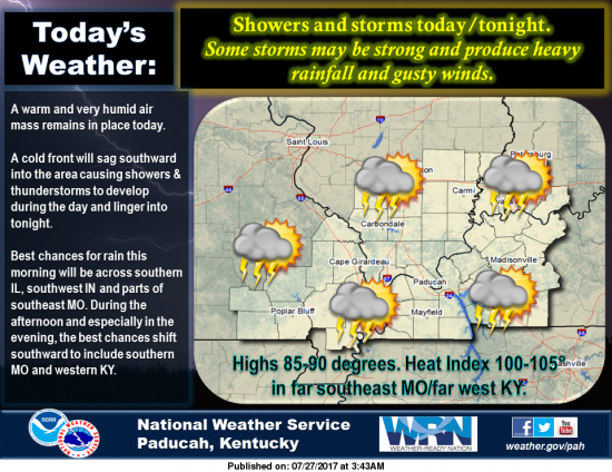
Over the next few hours, we will receive moderate to heavy rainfall, with a few rumbles of thunder, across Southern Illinois.  The large area of showers extends into Northeast Missouri.

It is on my bucket list to download a radar program, with velocity on storms.  My estimate is the storms are moving at a good clip at 30-40 mph.

We are still under a marginal risk for severe weather.  This will mainly be determined if the sun will come out after this round of percipitation, to provide instability in the atmosphere.  It is possible this large area of precipitation that is coming through will take a lot of the convective energy with it.

I do not have any scientific evidence to prove this, but it is out of observation.  Storms have been moving northwest to southeast now for about a month.  There is a possibility that we might have an early fall.

With winds shifting to the NNE after the cold front passes in the next 24 hours, they will blow the humidity out of here for the weekend.  With highs in the low 80’s, the air will have a fall feel to it.

Temperatures will moderate into the mid to upper 80’s by mid week.  There is not a 90 degree day in sight.  Enjoy it, and give your air conditioner a break, as window opening weather is on the way.

Below, is the Hazardous Weather Outlook and the Seven Day Forecast.

Hazardous Weather Outlook
National Weather Service Paducah KY
335 AM CDT Thu Jul 27 2017

This Hazardous Weather Outlook is for portions of southern
Illinois, southwest Indiana, western Kentucky, and southeast
Missouri.

.DAY ONE…Today and Tonight

Scattered to numerous thunderstorms will move across the northern
parts of the region today and across all of the area by this
afternoon or evening. A few severe thunderstorms with damaging
wind gusts are possible. Locally heavy rain is expected.

Across southeast Missouri and southern parts of western Kentucky,
heat indices may reach 100 to 105 degrees before the storms
arrive.

.DAYS TWO THROUGH SEVEN…Friday through Wednesday

A chance of thunderstorms will continue Friday morning across all
of the area and across mainly western Kentucky Friday afternoon.

.SPOTTER INFORMATION STATEMENT…

Spotter activation may be requested this afternoon and tonight for
reports of severe weather including heavy rain and flooding.

Detailed Forecast

Thursday
Showers and thunderstorms likely, mainly after 11am. Cloudy, with a high near 86. Southwest wind 3 to 8 mph. Chance of precipitation is 70%.
Thursday Night
Showers and thunderstorms likely, mainly before 10pm. Mostly cloudy, with a low around 71. West southwest wind around 6 mph becoming calm. Chance of precipitation is 60%.
Friday
A 20 percent chance of showers and thunderstorms before 1pm. Partly sunny, with a high near 85. North wind 5 to 11 mph.
Friday Night
Mostly clear, with a low around 63. North northeast wind 5 to 8 mph.
Saturday
Sunny, with a high near 81. North northeast wind 6 to 10 mph.
Saturday Night
Clear, with a low around 58. North northeast wind 3 to 7 mph.
Sunday
Sunny, with a high near 83. Northeast wind 3 to 6 mph.
Sunday Night
Mostly clear, with a low around 61. Northeast wind 3 to 6 mph.
Monday
Sunny, with a high near 85. Northeast wind 3 to 6 mph.
Monday Night
Mostly clear, with a low around 63. East northeast wind 3 to 6 mph.
Tuesday
Sunny, with a high near 88. East wind 3 to 5 mph.
Tuesday Night
Partly cloudy, with a low around 65. East northeast wind around 5 mph becoming calm in the evening.
Wednesday
Mostly sunny, with a high near 88. Light and variable wind.

Updated Hazarous Weather Outlook

Stormy Thursday….After front passes early Friday Morning, an awesome weekend on Tap

By Steve Dunford

The Storm Prediction Center has placed Southern Illinois in a marginal risk (level 1 of 5) risk of severe weather for tonight.  The good news is they have downgraded us from a slight risk to a marginal for tomorrow at this time.

Friday through Sunday will be a gorgeous day to be out in Southern Illinois.  Highs should be in the low 80’s with the low at night around 60.

The updated hazardous Weather Outlook and forecast is below.

Hazardous Weather Outlook
National Weather Service Paducah KY
426 PM CDT Wed Jul 26 2017

.DAY ONE…Tonight

A Heat Advisory remains in effect until 8 PM for southeast
Missouri, most of southern Illinois, and western Kentucky except
the Pennyrile region. Heat indices will remain around 105 degrees
away from thunderstorm activity.

There is a chance of thunderstorms tonight, mainly along and north
of a line from Carbondale to Owensboro. The main hazards will be
locally heavy rain and gusty winds up to 40 mph.

.DAYS TWO THROUGH SEVEN…Thursday through Tuesday

Thunderstorms are likely Thursday and Thursday night as a strong
cold front moves across our region. A few severe thunderstorms
with damaging wind gusts are possible. Locally heavy rain is
expected.

Across southeast Missouri and southern parts of west Kentucky,
heat indices may reach 100 to 105 degrees before the storms
arrive Thursday.

.SPOTTER INFORMATION STATEMENT…

Spotter activation may be requested Thursday afternoon and night.

This Afternoon
Scattered showers and thunderstorms. Mostly sunny, with a high near 94. South southwest wind around 7 mph. Chance of precipitation is 30%.
Tonight
A 30 percent chance of showers and thunderstorms, mainly after 2am. Mostly cloudy, with a low around 75. South wind 5 to 7 mph.
Thursday
Showers and thunderstorms likely, mainly after noon. Some of the storms could produce heavy rainfall. Cloudy, with a high near 87. Southwest wind 5 to 7 mph. Chance of precipitation is 60%.
Thursday Night
Showers and thunderstorms likely, mainly before 2am. Some of the storms could produce heavy rainfall. Mostly cloudy, with a low around 71. West southwest wind around 6 mph becoming calm. Chance of precipitation is 60%.
Friday
A 30 percent chance of showers and thunderstorms before 8am. Some of the storms could produce heavy rainfall. Partly sunny, with a high near 85. North wind 5 to 9 mph.
Friday Night
Mostly clear, with a low around 64. North northeast wind 6 to 9 mph.
Saturday
Sunny, with a high near 82. North northeast wind 6 to 9 mph.
Saturday Night
Clear, with a low around 60. Northeast wind 3 to 8 mph.
Sunday
Sunny, with a high near 83. Northeast wind 3 to 6 mph.
Sunday Night
Mostly clear, with a low around 61. Northeast wind 3 to 6 mph.
Monday
Sunny, with a high near 85. Northeast wind 3 to 5 mph.
Monday Night
Mostly clear, with a low around 65. East northeast wind around 5 mph becoming calm in the evening.
Tuesday
Sunny, with a high near 88. Light and variable wind.
Tuesday Night
Partly cloudy, with a low around 66. East northeast wind around 5 mph becoming calm in the evening.
Wednesday
A slight chance of showers and thunderstorms. Mostly sunny, with a high near 88. Light and variable wind
Benton, West Frankfort, Illinois News | Franklin County News