Information about the heat…updated list of cooling centers

by Steve Dunford

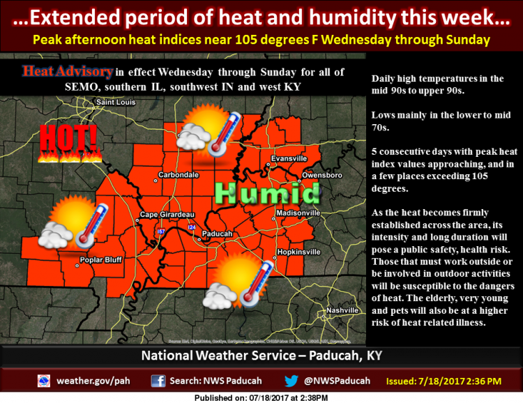
The Heat Advisory is still in effect until Sunday.  I would not be surprised if the National Weather Service ups it to an Excessive Heat Warning.  The NWS in St. Louis has had one for two days.

Here are some area temperatures and heat indexes across the region

  • Mt. Vernon 96 degrees/heat index 109
  • Marion 95 degrees/ heat index 103
  • Carbondale 93 degrees/ heat index 103

Here is an updated list of cooling centers across the county:

Benton:

City Hall

Fire Department

Township Community Building

West Frankfort:

Police Department

Sesser:

City Hall – Please use the police department entrance.

Christopher:

First Baptist Church will be having the lunch program between 11am till 1pm.  Kids 18 and under ear free.  Adults it is $3.00


Ranger attacked by pack of dogs

http://www.bentoneveningnews.com/news/20170719/ranger-attacked-by-pack-of-dogs

BENTON, IL –  (Rick Hayes, Benton News.  Please click on the link for the full story.  Here is an excerpt below.)

Less than a week on the job, the Benton Police Department’s new canine, Ranger, sustained injuries when he was attacked by a pack of dogs at his handler’s residence.

According to initial reports, Ranger was undergoing training with his handler, Officer Mark Wilkey, late Sunday night when the attack occurred.

About four dogs owned by Wilkey’s neighbor in the Hill City area turned on Ranger in an unprovoked attack, according to Chief of Police Kyle Melvin. The attack took place around 10 p.m., according to Thad Snell, Franklin County animal control supervisor, who responded to the incident


One fatality, two injured in a semi crash on I-57

by Steve Dunford

INA, IL – There have been several posts on social media about a serious accident on southbound interstate 57 just north of the Franklin/Jefferson county line.

I spoke with a representative from the Jefferson County Sheriff’s department and said the interstate is closed at the 57/64 split and diverting traffic to Route 37.  The interstate will be closed for several hours.

I am unsure of the northbound lanes at this time, as they usually back up.  I would seek an alternate route as well.

If you are heading to the west side of Franklin County, I would suggest taking Illinois 148.  If you are heading to the east side of the county, I would suggest using Log Cabin Road off of State Route 142.

I need you all to be my eyes to the public, if there is any traffic backing up in the Benton on East or West Main, please let me know, as well as any in the Cities of Christopher and Sesser, because Routes 148 and 14 could get heavy as well.

I will provide further updates as information becomes available.

UPDATE:  Here is a link to the story from WSIL http://www.wsiltv.com/story/35930799/isp-fatal-crash-shuts-down-i-57-near-ina

UPDATE:  12:30 p.m.  Route 37 is backed up in Bonnie.  Here is an option if you need to get to the east side of the county from Mt. Vernon, you can take Interstate 64 to the Belle Rive- Bluford exit (at the 89 Mile Marker),  Go south and that takes you into Belle Rive.  Go East into Dahlgren.  Go south out of town, and it will take you to Route 14.  If going toward Rend Lake College and Wayne Fitzgerell is backed up in Bonnie, you can go East out of town and the road winds around to the Ewing Blacktop.

I talked to Central Dispatch and 148 is in good shape as of now.  If someone would tell how traffic is flowing on North Main and West Main in Benton let me know, especially around the Benton square.

UPDATE:  5:00 p.m.  The interstate is now open.  There was one killed with two injuries.  Here is a link to the latest story from KFVS – TV.

http://www.kfvs12.com/story/35930956/1-dead-2-injured-in-crash-on-i-57-in-jefferson-co-il-involving-multiple-semi-trucks?utm_content=bufferc512b&utm_medium=social&utm_source=facebook.com&utm_campaign=buffer


Franklin County Officials Urge Preparedness for Extreme Heat

Press Release from Ryan Buckingham, Director of Franklin County Emergency Management Agency

County officials also want to stress the importance of checking on your neighbors and other citizens that may have functional or special needs. “We are well known in Southern Illinois for taking care of our own, friend to friend, neighbor to neighbor. If you know of someone that may be venerable to extreme temperatures, take moment to check on them from time to time” added Director of Emergency Management Ryan M. Buckingham.

Officials want to remind you of the following tips for avoiding injury and death with extreme heat:\

  • Stay out of the sun. If you must be in the sun, wear sunscreen (at least SPF 15) and a wide-brimmed hat. 
  • Stay in the shade or under awnings as much as possible. 
  • Avoid overexertion and strenuous outdoor activities. 
  • Wear lightweight, light-colored, loose-fitting clothes that cover as much skin as possible to prevent sunburn. 
  • Consume plenty of non-alcoholic, non-caffeinated fluids, even if you don’t feel thirsty. Water, diluted juices, and electrolyte solutions are best. Stay away from carbonated drinks. Avoid alcohol. 
  • If you are on a fluid-restricted diet or taking diuretics, consult your doctor before exposing yourself to heat. 
  • Keep lights in your home low or off, keep shades drawn, and avoid using the oven.
  • Keep rooms well ventilated with air conditioners and fans. Keep your windows open if you don’t have air conditioning or a fan. 
  • Cool down with cool, wet towels and periodic cool baths or showers. 
  • Take advantage of cooling centers, public pools, and air-conditioned stores and malls during periods of extreme heat.
  • Exposure to air conditioning for even a few hours a day will reduce the risk for heat-related illness. 
  • Closely monitor children, the elderly, or those who require special care during periods of intense summer heat. 
  • Do not leave children or pets in a closed vehicle, even for a few minutes. On a hot day, temperatures inside a closed vehicle can reach 140ºF-190ºF within 30 minutes.
  • Make a special effort to check on your neighbors during a heat wave, especially if they are seniors, families with young children, people with special needs, or living alone.
  • Seniors and others who may be sensitive to extreme heat should contact friends, neighbors, or relatives periodically throughout the day.
  • Seek help if you feel symptoms of heat-related illnesses. 

Pets are another major concern when temperatures rise. Franklin County Animal Control Supervisor Thad Snell reminds residents that animals can just as at risk to extreme temperatures as humans. “Never leave your pet in your vehicle. Keep your pet indoors and put out plenty of water for them to stay hydrated during hot summer days. If your pet must stay outdoors, provide ventilated shelter, baby pools filled with water, and sunscreen on pets with short hair” added Snell.  

For more information on emergency preparedness and extreme heat visit Franklin County Government online at www.franklincountyil.gov/preparedness

State ponies up reimbursement payment

http://www.bentoneveningnews.com/news/20170719/state-ponies-up-reimbursement-payment

BENTON, IL –  (Rick Hayes, Benton Evening News.  Please click on the link above for the full story.  Here is an excerpt below.)

The total bill owed by the state to Franklin County for probation and detention services has declined to under $1 million.

Treasurer Keith Jones reported at a Monday meeting the state has released a $300,000 reimbursement payment to the county, lowering the total state debt to about $748,000.

The county had considered an ordinance petitioning the Illinois Attorney General’s office to add the probation and detention officers of the Second Judicial Circuit in the A.G.’s action against the state to continue paying state employees. The General Assembly’s action to approve a budget reportedly made that a moot point

Cooling centers in the region

by Steve Dunford

As long as the heat wave lasts, I will pass on any emergency information on a timely basis.

I would appreciate any information that you might have.  Over the last few months, and especially during the flooding in late April, the citizens of the county has trusted franklincounty-news.com to be a reliable source of information in the county.

The site has good numbers in the Jefferson, Williamson, Perry, Hamilton and Saline counties as well now.  Franklin County will be the top priority, but I will start sharing info from those counties as well.

Please contact me at 513-1274, 937-0253, send me a message on Facebook or email me at sdunford1970@hotmail.com

FRANKLIN COUNTY:

BENTON

City Hall – 8:00 to 5:00 p.m. Monday-Friday

Benton Fire Department

Benton Community Building

SESSER

City Hall – Please use the police entrance

CHRISTOPHER

First Baptist Church is hosting their summer meal program, free for kids 18 and under.  For adults the cost is $3.  The time is 11:00 a.m. to 1:00 p.m. You are welcome to come and cool off.


Jackson County Board votes down resoulution to become a sancturary county

http://www.kfvs12.com/story/35905149/jackson-co-il-board-votes-no-on-safe-welcoming-county-resolution

MURPHYSBORO, IL – (Hank Cavagnaro and Brittany Jacob, KFVS-TV.  Please click on the link above for the full story and video.  Here is an excerpt below.)

The Jackson County, Illinois board voted no with a 6 to 6 vote on a controversial resolution during the monthly board meeting on Tuesday, July 18.

The resolution will not pass.

The meeting was packed with standing room only as both sides took turns stating their reasoning. After more than 10 people spoke, the commission then shared their thoughts on why they were voting for or against the resolution.

Some were interrupted while speaking, others had boo’s and clapping after they finished

Safety Tips for heat related illnesses

From the National Weather Service – Paducah, KY

During extremely hot and humid weather, your body’s ability to cool itself is challenged. When the body heats too rapidly to cool itself properly, or when too much fluid or salt is lost through dehydration or sweating, body temperature rises and you or someone you care about may experience a heat-related illness. It is important to know the symptoms of excessive heat exposure and the appropriate responses. The Centers for Disease Control and Prevention provides a list of warning signs and symptoms of heat illness, and recommended first aid steps. Some of these symptoms and steps are listed below. Click on the infographics below for a full size version.

Heat Cramps:

Heat cramps may be the first sign of heat-related illness, and may lead to heat exhaustion or stroke.Symptoms:

  • Painful muscle cramps and spasms usually in legs and abdomen
  • Heavy sweating

First Aid:

  • Apply firm pressure on cramping muscles or gently massage to relieve spasm.
  • Give sips of water unless the person complains of nausea, then stop giving water

Heat Exhaustion:

Symptoms:

  • Heavy sweating
  • Weakness
  • Cool, pale, clammy skin
  • Fast, weak pulse
  • Possible muscle cramps
  • Dizziness
  • Nausea or vomiting
  • Fainting

First Aid:

  • Move person to a cooler environment
  • Lay person down and loosen clothing
  • Apply cool, wet cloths to as much of the body as possible
  • Fan or move victim to air conditioned room
  • Offer sips of water
  • If person vomits more than once, seek immediate medical attention.

Heat Stroke:

Symptoms:

  • Altered mental state
  • One or more of the following symptons: throbbing headache, confusion, nausea, dizziness, shallow breathing
  • Body temperature above 103°F
  • Hot, red, dry or moist skin
  • Rapid and strong pulse
  • Faints, loses consciousness

First Aid:

  • Heat stroke is a severe medical emergency. Call 911 or get the victim to a hospital immediately. Delay can be fatal.
  • Move the victim to a cooler, preferably air-conditioned, environment.
  • Reduce body temperature with cool cloths or bath.
  • Use fan if heat index temperatures are below the high 90s. A fan can make you hotter at higher temperatures.
  • Do NOT give fluids.

Heat advisory in effect until Sunday

…Dangerous heat and humidity Wednesday through Sunday…

.A large upper level high will produce a dome of heat and
humidity across the region through Sunday. The combination of the
heat and humidity will produce maximum heat index values over 100
degrees each day from the late morning to late afternoon hours,
with peak heat index values pushing 105 degrees or slightly higher
some areas. Actual high temperatures will be in the mid 90s, and
in a few places upper 90s.

Hazardous Weather Outlook
National Weather Service Paducah KY

This Hazardous Weather Outlook is for portions of southern
Illinois, southwest Indiana, western Kentucky, and southeast
Missouri.

.DAY ONE…Today and Tonight

Dangerous heat and humidity will spread across the region starting
today. The heat index will top 100 degrees this afternoon in most
areas. A Heat Advisory begins today around noon and runs through
the weekend. Please refer to the Advisory product for details.

.DAYS TWO THROUGH SEVEN…Thursday through Tuesday

Afternoon heat indices will continue to top 100 degrees through
the weekend with some locations peaking near or slightly higher
than 105 degrees. A Heat Advisory will continue through Sunday. Please
refer to the Advisory product for details.

A chance of thunderstorms returns late Saturday night into the
first part of next week. The main threats with any storms will be
lightning and heavy rain.

.SPOTTER INFORMATION STATEMENT…

Spotter activation is not anticipated.

Detailed Forecast

Today
Patchy fog before 9am. Otherwise, sunny, with a high near 95. Heat index values as high as 105. Calm wind becoming west southwest around 5 mph in the morning.
Tonight
Mostly clear, with a low around 73. Light south wind.
Thursday
Sunny, with a high near 96. Heat index values as high as 106. Southwest wind 3 to 6 mph.
Thursday Night
Mostly clear, with a low around 75. South southwest wind 3 to 5 mph.
Friday
Sunny, with a high near 96. South southwest wind 3 to 8 mph.
Friday Night
Mostly clear, with a low around 76. South southwest wind around 6 mph.
Saturday
Sunny, with a high near 95. Southwest wind around 7 mph.
Saturday Night
A slight chance of showers and thunderstorms after 1am. Partly cloudy, with a low around 76. South southwest wind around 7 mph.
Sunday
A chance of showers and thunderstorms, mainly before 1pm. Partly sunny, with a high near 92. Southwest wind around 6 mph.
Sunday Night
A chance of showers and thunderstorms. Partly cloudy, with a low around 71. Southwest wind around 6 mph.
Monday
Mostly sunny, with a high near 87. Northwest wind around 6 mph.
Monday Night
Partly cloudy, with a low around 66. Northeast wind 3 to 5 mph.
Tuesday
Mostly sunny, with a high near 86. North northeast wind 3 to 6 mph.


Heat advisory Wednesday through Sunday

…Dangerous heat and humidity Wednesday through Sunday…

.A large upper level high will produce a dome of heat and
humidity across the region from Wednesday through Sunday. The
combination of the heat and humidity will produce maximum heat
index values over 100 degrees each day from the late morning
to late afternoon hours, with peak heat index values pushing 105
degrees or slightly higher some areas. Actual high temperatures
will be in the mid 90s, and in a few places upper 90s.

…HEAT ADVISORY IN EFFECT FROM NOON WEDNESDAY TO 7 PM CDT
SUNDAY…

The National Weather Service in Paducah has issued a Heat
Advisory, which is in effect from noon Wednesday to 7 PM CDT
Sunday for all of southeast Missouri, southern Illinois, southwest
Indiana and western Kentucky. The Excessive Heat Watch is no
longer in effect.

* TIMING…Wednesday afternoon through Sunday evening.

* HEAT INDEX VALUES…topping the 100 degree mark from midday
through late afternoon, peaking near 105 degrees or slightly
higher in some areas.

* IMPACTS…The combination of hot temperatures and high humidity
will lead to an increased risk of heat related stress and
illness. The very young, the elderly, those without air
conditioning, and those participating in strenuous outdoor
activities will be the most susceptible. Also, car interiors
will reach lethal temperatures in a matter of minutes.

PRECAUTIONARY/PREPAREDNESS ACTIONS…

A Heat Advisory means that a period of hot temperatures is
expected. The combination of hot temperatures and high humidity
will combine to create a situation in which heat illnesses are
possible. Drink plenty of fluids…stay in an air-conditioned
room…stay out of the sun…and check up on relatives and
neighbors.

Benton, West Frankfort, Illinois News | Franklin County News