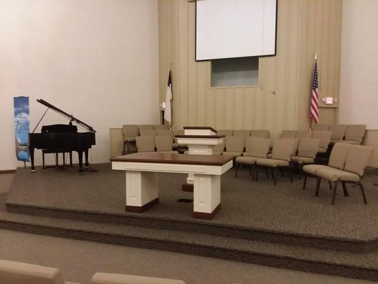
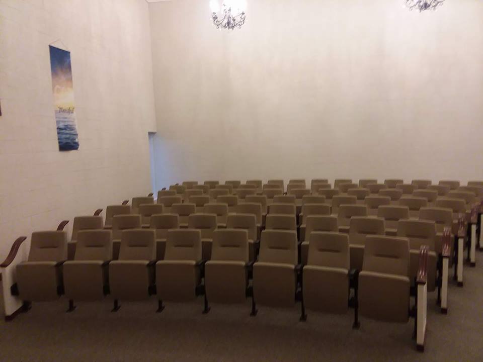
Benton Council nixes Harrison mural painting

http://www.bentoneveningnews.com/news/20170712/benton-council-nixes-harrison-mural-painting

BENTON, IL  –  (Rick Hayes, Benton News.  Please Click on the link for the full story.  Here is an excerpt below.)

Reasoning that it has no economic benefit to the city, Benton City Council members on Monday nixed the idea of a proposed Beatles-themed mural near Interstate 57.

John Cerney of Salinas, Calif., had entertained the idea of painting the 16-foot mural depicting George Harrison and his fans on city-owned property between airport property and the interstate.

“He chose Benton to donate his art for one year. He chooses somewhere across the country every year,” Rachel Gartner, the city’s public information coordinator, said at a council meeting two weeks ago. “He is interested in the story behind George Harrison visiting his sister (Louise) here.”

Marginal risk for Severe Weather for Route 13 South

by Steve Dunford

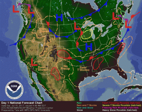
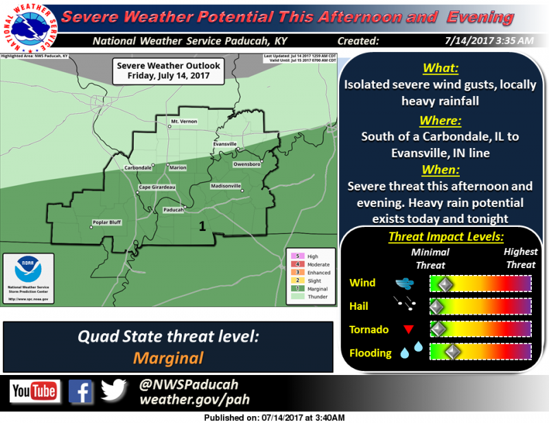
We had two rounds of a couple pretty heavy showers and thunderstorms that crossed the region last night.  There was a few reports of limbs down across Franklin County.

There is a marginal (level one of five) risk for severe thunderstorms for this afternoon and evening south of a Carbondale to Evansville, IN line.

As far as precipitation for the next few hours, there is a line of storms that are stretching from Clinton County through Northern Marion County at this time.  They are drifting ESE.  If they stay together, they can bring some showers and possible rumbles of thunder to Franklin county.

Below is the Hazardous Weather Outlook and the seven day forecast for Franklin County.


This Hazardous Weather Outlook is for portions of southern
Illinois, southwest Indiana, western Kentucky, and southeast
Missouri.

.DAY ONE…Today and Tonight

There is a marginal risk of severe weather this afternoon and
evening south of a line from Carbondale,IL to Evansville, IN.
Isolated severe wind gusts are possible.

Locally heavy rainfall is possible today and tonight across the
entire area. Flooding of low lying or poor drainage locations are
possible.

.DAYS TWO THROUGH SEVEN…Saturday through Thursday

Thunderstorms are possible Saturday over southern Missouri and
southern Kentucky. Severe storms are not expected, but locally
heavy rainfall is possible.

Thunderstorms are possible along the I-64 corridor on Thursday.
Severe storms are not expected at this time.

Heat index values on Tuesday, Wednesday, and Thursday afternoons
will range from 100 to 105 over much of the area.

.SPOTTER INFORMATION STATEMENT…

Spotters may be activated at isolated locations this afternoon and
evening.

Seven Day Forecast for Franklin County

Today
Scattered showers and thunderstorms before 3pm, then isolated showers and thunderstorms after 5pm. Partly sunny, with a high near 87. North wind 3 to 5 mph. Chance of precipitation is 40%.
Tonight
Mostly cloudy, with a low around 67. Light north northeast wind.
Saturday
Sunny, with a high near 84. North wind 3 to 5 mph.
Saturday Night
Mostly clear, with a low around 64. Light northeast wind.
Sunday
Sunny, with a high near 89. Calm wind becoming north northwest around 5 mph in the afternoon.
Sunday Night
Mostly clear, with a low around 67. Light and variable wind.
Monday
Sunny, with a high near 89. Light and variable wind.
Monday Night
Mostly clear, with a low around 69. Light and variable wind.
Tuesday
Sunny, with a high near 92. Light and variable wind.
Tuesday Night
Mostly clear, with a low around 71. Light and variable wind.
Wednesday
Sunny, with a high near 93. Light south southwest wind.
Wednesday Night
Mostly clear, with a low around 73. Light south wind.
Thursday
Mostly sunny, with a high near 94. Southwest wind 3 to 6 mph.


Franklin County fire departments have a busy night

by Steve Dunford

WSIL – TV photo

BENTON and WEST FRANKFORT IL-  There were two major fires in the county overnight, one in Benton and the other in West Frankfort.  Both were MABAS box alarms and there were injuries at each.  The incidents were less than two hours apart.

At 1:37 a.m. Benton firefighters were toned to a structure fire on 1203 E Bond street.  West City, West Frankfort, Christopher, and Sesser fire departments  were called to the scene for Mutual Aid.

Original repots say the fire was contained to the attic, but Benton fire was toned back to the scene at 6:37 a.m. for a rekindle.

At 3:18 a.m. West Frankfort firefighters were toned to the 100 block of West 5th street for a structure fire that was described as having major fire showing.  Johnston City, Benton, Marion, Zeigler, and West City departments were called for mutual aid.

There were two residents as well as one firefighter injured at the scene.

In two other incidents, Benton Firefighters were called to 1107 N McLeansboro street at 7:17 last night, for a tree on a residence.

Around 7:00 a.m. this morning, West Frankfort firefighters were called to the Anna Gray High Rise, for a malfunctioning smoke detector on the third floor, of a vacant apartment.

I will try to contact Benton and West Frankfort fire officials with additional information on the structure fires this afternoon.

Information from WSIL-TV, Southern Illinois Fire Incidents, Southern Illinois Fire Dispatch, and the Zeigler Fire Department contributed to this story.


Bost Meets with Secretary Carson to Discuss Cairo Housing Crisis

by George O’ Connor – Communications Director for Congressman Mike Bost

Washington, D.C. – U.S. Representative Mike Bost today met with Housing and Urban Development (HUD) Secretary Ben Carson to discuss the ongoing housing crisis in Cairo, Illinois.

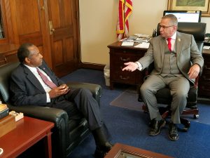
“Secretary Carson and I had a frank discussion about the housing crisis in Cairo and failures in the system that helped create it,” said Bost. “Cairo’s suffering is due to years of fraud and corruption at the highest levels of the housing authority, a fact that was highlighted this week as HUD announced that several local housing officials accused of lining their pockets with federal housing funds have been indefinitely banned from seeking similar positions in the future. Ignoring past mistakes will do little to bring justice for the families victimized by the previous housing authority leadership or help them find the safe and sanitary housing they deserve. However, I am hopeful that new leadership is bringing a renewed commitment to getting Cairo back on its feet.”

Background:

A 2015 report in The Southern Illinoisan newspaper exposed the plight of Cairo, Illinois, residents living in United States Department of Housing and Urban Development (HUD) funded public housing units managed by the Alexander County Housing Authority (ACHA).  Living conditions at two of the authority’s housing units – Elmwood and McBride – are extremely unsafe and unsanitary, in large part due to the neglect of the housing authority and the mismanagement of federal housing funds and potential fraud committed by its employees.

Given the poor physical condition of the Elmwood and McBride properties, and the insolvency of the ACHA’s financials, HUD has determined are beyond rehabilitation.  Now local residents, specifically the nearly 400 who live at the Elmwood and McBride properties, have been served notice by HUD that they must vacate their units in return for vouchers and counseling services that could compel them to relocate far away from the only community many of them have ever known.

Slow moving storms approaching Franklin County

Radar Update at 5:50 PM: A broken band of thunderstorms will continue to slowly sag southward into northern portions of southern Illinois through the evening. An isolated storm is possible elsewhere. The stronger storms may produce hail up to 1 inch in diameter and wind gusts of 40 to 50 mph. Due to the slow movement, heavy rain may lead to localized flooding as well.

Wreck on I – 57 Northbound near the I – 24 split

The Illinois State Police sent in the following traffic accident alert at 4:43 p.m., Thursday, July 13.

“All I-57 Northbound lanes are currently closed at milepost 44 ( just south of I-24) due to a crash involving three truck tractor / semi trailers.  It is anticipated that I-57 northbound will be closed for a significant amount of time for recovery and cleanup.  Northbound I-57 traffic is currently being diverted off of the interstate at Exit 30 (IL. Rt. 146). People traveling northbound on I-57 should use caution and seek an alternate route.

Updates will be provided as they are available.”

This subsequent update was sent in by the ISP at 5:04 p.m.

“Northbound I-57 traffic is now being diverted off the interstate at Exit 40.  Recovery crews are working to open one northbound lane just south of the I-24 split.”

Looking Back: Sesser took the brunt of a severe storm that went through the county one year ago today

by Steve Dunford

SESSER, IL –  I had my memories pop up on Facebook in the last few minutes  I was reminded that one year ago today, that Franklin County had a severe thunderstorm roll through that afternoon.

The brunt of the damage was in the Sesser Area.  I had several pictures of wind damage.  The picture is of d downed  tree in Jim and Carleen Roberts yard on the north side of the city.  It also shows pieces of their smashed produce stand .  Hopefully, I will be writing a story about their endeavors some time next week.

The posts from that afternoon came from my high school sports blog, Franklin County Hoops and Gridiron.  Since it is a dedicated group, I began to share emergency information on that site.

I was in frequent contact with Sesser Mayor Jason Ashmore that afternoon.  Not only Sesser, but most of the west side of the county experienced damage.  Valier was hit pretty hard as well.

Ameren-Illinois reported over 4,000 customers throughout power.  There was a brief power outage in West Frankfort, as 70 mph winds were clocked just to the west of town.

Benton, Thompsonville, as well as the rest of the east side of the county experienced little damage, as the cell began to weaken.

With a very small chance of severe weather today, pray we do not have a repeat.


Bost Backs Bills to Fight Human Trafficking

by George O’Connor – Communications Director for Congressman Mike Bost

Washington, DC – U.S. Representative Mike Bost (R-Murphysboro) joined a bipartisan coalition in Congress to pass a trio of bills cracking down on human trafficking and implementing a stronger detection system nationwide.

“It should anger each and every one of us that Illinois ranks in the top 10 states for reported cases of human trafficking,” said Bost. “When Boko Haram kidnapped 200 teenage girls in Nigeria in 2014, human trafficking became a hashtag and garnered attention from countries around the world. But we’re wrong to assume that this modern-day form of slavery is an isolated tragedy in some faraway nation. Reported cases of trafficking continue to rise in Illinois. Our work is far from over, but these bills are vitally important to help protect American families.”

Background:

  • There are over 20 million people enslaved around the world but few of them are ever identified as human trafficking victims.
  • The International Labour Organization reports that three out of every 1,000 people are “trapped in jobs into which they were coerced or deceived.”
  • Illinois ranks 9th in cases reported in 2016.
  • In 2016, the National Human Trafficking Hotline has received 26,727 calls, and 7,572 human trafficking cases reported.
  • This multi-billion-dollar illicit industry helps fund international criminal networks and even terrorist groups, threatening U.S. national security and international stability.

New superintendent explains path to improvement

http://www.wfgazette.com/news/new-superintendent-explains-path-to-improvement/article_847bafae-671f-11e7-bc51-b36d5db5c7f6.html

WEST FRANKFORT, IL (Tim Hastings, West Frankfort Gazette.  Please click on the link for the full story.  Here is an excerpt below. Photo contributed to the Gazette.)

The new superintendent of Frankfort Community Unit School District 168 said Thursday he is looking “rapidly and deliberately” at finances, personnel, curriculum, and procedures in order to give students the opportunities and resources to succeed and be good citizens.

Matt Donkin, who became superintendent on July 1, said he will be asking staff to define what it is they do; explain how they do it; examine whether the procedure is working, and to suggest ways it could be improved.

“I told the principals and the administrative office staff on the first day that I’m going to be asking four questions repeatedly,” Donkin said.  “These are: ‘What is it?’; ‘How are we doing it?’; ‘Does it work?’; and ‘Could it be done better?’”


Triple digit heat index -marginal risk for severe weather this evening

by Steve Dunford

The National Weather service issued a special weather statement in regards to the heat this afternoon.  Heat indexes are to be between 100-105.

There is a marginal risk (level one of five) for severe weather for this afternoon into the overnight hours for Franklin County and most of Southern Illinois.  As you can see from the graphic to the left,  There are a few counties in Southern Illinois that are on the edge of a slight risk (level 2 of severe weather).

The Storm Prediction Center is in discussions of changing the term slight risk to an elevated risk.  Some meteorologists in this market already use that term.

This is what I expect.  The cloud cover should be lifting at any time.  In the late afternoon hours, you could see one or two pop up storms that could turn severe.

This is in advance of an approaching cold front.  There should be a line of storms that will move through the area from northwest to southeast.  The best time for them to reach Franklin County is between 10 and 11 p.m.  There is the possibility of one or two severe thunderstorm warnings being issued during this time.

The main threat is damaging winds, with large hail being secondary.  The tornado threat is near zero.

Please follow the website and especially the Facebook page for any watches or warnings.  Below is the Special Weather Statement involving the heat and the hazardous weather outlook.  At the end is the seven day forecast, which I will post daily from this point on.   The forecast will pinpoint on Franklin County.

If you are going north or west toward the St. Louis Metro area, there is a heat advisory for heat indices running from 105-110

SPECIAL WEATHER STATEMENT
NATIONAL WEATHER SERVICE PADUCAH KY

…Heat Index Values of 100 to 105 degrees expected today over
most of the area…

Another afternoon of oppressive heat and humidity can be expected
today, leading to heat index values between 100 and 105 degrees.

The highest heat index values will be over southeast Missouri and
southern Illinois where isolated location may briefly reach 105.
Values of 100 to 102 are possible over southwest Indiana and west
Kentucky.

A few showers and thunderstorms are expected today, especially
near I-64, which will help keep the heat down at a few locations.

Be watchful for those especially impacted by the heat. Young
children, the elderly, persons with serious health issues, and
pets are especially susceptible to the heat during this time of
year.

Do not leave young children or pets in cars with closed
windows…this could become deadly situation in a short period of
time.

Be sure to drink plenty of water, take frequent rest breaks in the
shade or air conditioned shelter. Get out of the heat, if you are
experiencing health issues.

Hazardous Weather Outlook
National Weather Service Paducah KY

.DAY ONE…Today and Tonight

There is a slight risk of severe thunderstorms this afternoon and
evening generally north of Interstate 64 in southern Illinois and
southwest Indiana. There is a marginal risk north of a line from
Cape Girardeau Missouri to near Owensboro Kentucky. Damage wind
gusts and locally heavy rainfall will be the main hazards.

Heat and humidity will push heat index values into the 100 to 105
range across much of the area this afternoon.

.DAYS TWO THROUGH SEVEN…Friday through Wednesday

There is a marginal risk of severe thunderstorms Friday afternoon
and evening across much of the area. Damaging wind gust and
locally heavy rainfall will be the main hazards.

A few thunderstorms are possible Sunday afternoon and evening.
Severe storms are not expected during that time.

Heat index values will reach the 100 to 105 range during Tuesday
and Wednesday afternoons, mainly over southeast Missouri and
adjacent areas of southern Illinois and west Kentucky.

.SPOTTER INFORMATION STATEMENT…

Spotter activation may be necessary this afternoon and evening.

Detailed Forecast

This Afternoon
Scattered showers and thunderstorms, mainly before 4pm. Partly sunny, with a high near 93. West southwest wind around 6 mph. Chance of precipitation is 40%.
Tonight
Showers and thunderstorms likely, mainly between 10pm and 11pm. Mostly cloudy, with a low around 73. Southwest wind around 5 mph becoming calm in the evening. Chance of precipitation is 60%.
Friday
A 20 percent chance of showers and thunderstorms before 1pm. Partly sunny, with a high near 87. Northwest wind 3 to 7 mph.
Friday Night
Partly cloudy, with a low around 65. North northwest wind around 5 mph becoming calm after midnight.
Saturday
Sunny, with a high near 84. Calm wind becoming north northeast around 5 mph in the morning.
Saturday Night
Mostly clear, with a low around 64. Light and variable wind.
Sunday
A 20 percent chance of showers and thunderstorms after 1pm. Sunny, with a high near 88. Light and variable wind.
Sunday Night
A slight chance of showers and thunderstorms before 1am. Mostly clear, with a low around 67. Light and variable wind.
Monday
Sunny, with a high near 88. North wind 3 to 5 mph.
Monday Night
Mostly clear, with a low around 67. Northeast wind around 5 mph becoming calm in the evening.
Tuesday
Sunny, with a high near 91. Light and variable wind becoming south southeast around 5 mph in the afternoon.
Tuesday Night
Mostly clear, with a low around 70. East wind around 5 mph becoming calm in the evening.
Wednesday
Sunny, with a high near 92. Calm wind becoming south around 5 mph in the afternoon.
Benton, West Frankfort, Illinois News | Franklin County News