ROAD CLOSURE: State Route 142 on the east end of Mt. Vernon

From the Jefferson County EMA 

Mt. Vernon –  PAY CLOSE ATTENTION TO THIS IF YOU WORK AT CONTINENTAL TIRE.

Be advised that State  Route 142 is currently closed at the railroad tracks on the east side of Mt. Vernon for railroad crossing construction. Please allow extra travel time and use marked detours.

Sen. Fowler provides update from IDOT on traffic signal in Harrisburg

HARRISBURG – State Senator Dale Fowler (R-Harrisburg) is providing an update on ongoing efforts to bring a stoplight to the accident-prone intersection of Route 13 and Poplar Street in Harrisburg, which was the scene of another traffic accident last week.

“This intersection has been the scene of numerous crashes over the years, underscoring the importance of taking steps to make the intersection safer for motorists,” said Sen. Fowler. “A stoplight will go a long way toward helping to improve road safety for the community and reducing the number of accidents at the busy crossroad.”

Sen. Fowler said the Illinois Department of Transportation (IDOT), in conjunction with the City of Harrisburg, will be installing traffic signals at the intersection of Illinois 13 and West Poplar Street (Old Illinois 13) on the west side of Harrisburg.

Sen. Fowler has worked with IDOT to conduct a traffic analysis on the ongoing safety concerns of the busy intersection, and is optimistic to see light at the end of the tunnel for this longstanding project.

“This was an issue that was brought to my attention when I was serving at the local level, and to be able to share progress on this project is encouraging. The safety of our community has to be paramount and bringing a stoplight to the area gives our motorists some measure of safety when they approach the intersection,” said Sen. Fowler.

Sen. Fowler says he hopes the traffic signal will help improve roadway safety at the intersection, as well as improve access to the area.

“I’m optimistic that this stoplight will help vehicles traverse the area better, allowing for better traffic flow and improving the possibilities of economic development along the roadway,” said Sen. Fowler. “Right now, gaining access through the intersection is difficult and sometimes dangerous. I hope this traffic signal will have the added benefit of enabling vehicles to get in and out of the area easier and encourage some business development as safety and organization is brought to the junction.”

According to IDOT, in January the state received bids from contractors to install the traffic signals. The low bid contractor was Brown Electric and a contract for $228,250 has been awarded to install traffic signals, pavement markings and concrete shoulders. The contract is in the process of being executed, work should begin this summer, and the new traffic signals should be in operation by the fall of 2018.

As the project continues into development, IDOT would like to remind motorists that traffic signals are not a solution for all traffic problems, urging motorists to obey the speed limit, always be alert and avoid distractions.

Sen. Fowler echoes their call for drivers to continue to be alert, follow the rules of the road and help keep the roadways as safe as possible for all motorists.

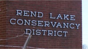
RLCD board passes 2.5 percent water rate hike

WSIL image

BENTON – Water will be a bit more expensive for hundreds of thousands of people in southern Illinois.

The Rend Lake Conservancy District board passed a 2.5 percent rate hike Monday morning.

Rend Lake Conservancy District General Manager Keith Thomason said the increase gives the district flexibility down the road to complete repairs.

“The Rend Lake Conservancy District is attempting to make these repairs and never have a significant rate increase, which means we have to look into the future and that we will not ever go cash negative,” Thomason said. “We’re going to pay as we go and we are not going to take big debt which then burdens our children in the future years to pay that debt for us.”

Please click on the link for the full story from Joe Ragusa of WSIL-TV

http://www.wsiltv.com/story/37596447/rlcd-board-passed-25-percent-water-rate-hike

Benton Mayor Lobbying for Federal Infrastructure Money

BENTON – During the Public Affairs Report at the Feb. 12 Benton City Council meeting, Mayor Kondritz said that Benton’s water department and infrastructure had been under a lot of stress due to recent weather and the aging of the city’s water and sewer lines.

 “I saw where President Trump introduced a $1.5 trillion (budget) bill, and I don’t care what you think about that situation. What I care about is that as the City of Benton, I want our slice of the federal pie,” Kondritz said.
Please click on the link for the full story from the Benton Gazette.

Enjoy this nice day……showers moving into the area starting tonight

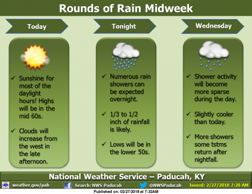
We will have one more mild day with sunshine today, with a southerly breeze, though clouds will increase from the west in the late afternoon. As a disturbance aloft moves across the region, showers are expected primarily after midnight tonight, amounting to less than an inch of rainfall. Clouds will remain Wednesday, with fewer showers around. Wednesday night, rain is expected to return with a vengeance, especially south of the Ohio River, as a low pressure system rolls by just to the north. Some thunderstorms are possible in the northern half of the region. Low lying and flood prone areas could have water issues. (NWS Paducah)

Flood Warning Continues on the Big Muddy Until Thursday

…The flood warning continues for the following rivers in
Illinois…

Big Muddy River near Plumfield
Big Muddy River near Murphysboro

.Flooding continues along the Big Muddy River. The river will crest
at Plumfield tonight at 23.2 feet and fall below flood stage on
Thursday morning. At Murphysboro the river will rise to moderate
flood stage tonight and crest at 30.5 feet Wednesday morning.

PRECAUTIONARY/PREPAREDNESS ACTIONS…

SAFETY MESSAGE…

Never drive cars…trucks or sport utility vehicles through flooded
areas. The water may be too deep to allow safe passage. Never allow
children to play in or near flood waters. Stay tuned to NOAA Weather
Radio or your local media for further statements and possible updated
forecasts.

Hazardous Weather Outlook

.DAY ONE…Today and Tonight

A 1/3 to 1/2 inch of rainfall is forecast across the region
tonight.

Numerous river flood warnings remain in effect. Please refer to
the warning products and their follow up statements for details.

.DAYS TWO THROUGH SEVEN…Wednesday through Monday

Additional rainfall of 1/3 inch northwest to 1 1/3 inch southeast
is forecast across the region during the Wednesday through
Thursday time frame. A chance of thunderstorms forecast for the
northern half of the region on Wednesday night will heighten the
risk for locally heavy rainfall amounts there. Refer to the
Hydrologic Outlook for more detailed information on this mid week
rain chance and its potential impacts.

Windy conditions are likely on Thursday behind a cold front.
Northwest winds could gust 30 to 40 mph at times.

A slight chance of thunderstorms is forecast for the entire region
Monday. Locally heavy rainfall will be the primary concern.

River flood warnings will remain in effect through much of the
week. Refer to the flood warnings and statements for important
river flood details, including the latest updated information.

Hydrologic Outlook

…ONE TO AS MUCH AS TWO INCHES OF RAINFALL POSSIBLE…

Another rain event is coming for the middle of this week for the
region. The rain will begin tonight, and will end Thursday.
During that time, we expect average rainfall to total between a
half inch across the northwestern tier of counties in southeastern
Missouri and southern Illinois, to nearly two inches close to the
Tennessee state line. Locally higher amounts in thunderstorms,
which are forecast for Wednesday night in the northern half of the
region, could cause rainfall totals to reach into the 1 to 2 inch
range there by the end of the day Thursday.

This amount of rainfall would not normally cause many issues.
However, given the still wet ground conditions from last week`s
rains, and the forecasted crests of river stages, you should
monitor local water conditions closely as this next rain occurs.
Low lands and poorer drainage areas may flood more quickly than
usual. This may extend ponding or flooding of water overtop back
country roads, especially ones near creeks and streams that may
swell more quickly than usual.

Stay tuned to all the latest forecasts and updates and keep an eye
for rising waters as rains hit during the mid week period.

Seven Day Forecast

Today
Increasing clouds, with a high near 65. South wind 6 to 14 mph, with gusts as high as 20 mph.
Tonight
Showers, mainly after midnight. Low around 50. South wind 7 to 10 mph. Chance of precipitation is 90%.
Wednesday
Showers likely, mainly before noon. Patchy fog after noon. Otherwise, cloudy, with a high near 62. East southeast wind around 7 mph becoming south southwest in the afternoon. Chance of precipitation is 60%.
Wednesday Night
Showers likely, with thunderstorms also possible after midnight. Cloudy, with a low around 49. South wind 6 to 10 mph, with gusts as high as 18 mph. Chance of precipitation is 70%.
Thursday
A 40 percent chance of showers before noon. Partly sunny, with a high near 54. Breezy, with a west southwest wind 11 to 20 mph becoming northwest in the afternoon. Winds could gust as high as 33 mph.
Thursday Night
Mostly clear, with a low around 32. North northwest wind 8 to 15 mph, with gusts as high as 25 mph.
Friday
Sunny, with a high near 50. North northeast wind 5 to 8 mph.
Friday Night
Clear, with a low around 31. East northeast wind around 6 mph.
Saturday
Sunny, with a high near 54. East southeast wind 5 to 7 mph.
Saturday Night
Clear, with a low around 34. East wind around 7 mph.
Sunday
Sunny, with a high near 57. Southeast wind around 8 mph.
Sunday Night
A chance of showers. Mostly cloudy, with a low around 42. Southeast wind around 9 mph.
Monday
A chance of showers and thunderstorms. Mostly cloudy, with a high near 54. South wind around 10 mph becoming west northwest in the afternoon.


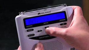
Franklin County EMA programming NOAA Weather Radios at Benton/West City Walmart

WEST CITY –  Join the Franklin County Emergency Management Agency, West City Fire Department during Severe Weather Preparedness Week for a FREE NOAA All-Hazards Radio Programming Event.  This will take place at the West City Walmart on Monday, March 5th between 8:00-4:00 p.m.

Please bring your radio by or purchase one at Walmart and we will program your radio to ensure you are weather ready!

Also, FCEMA will take part in basic storm spotter training that evening in West City.  Details will be coming soon. -sd

February 24, 2018 Severe Weather and Flooding Summary


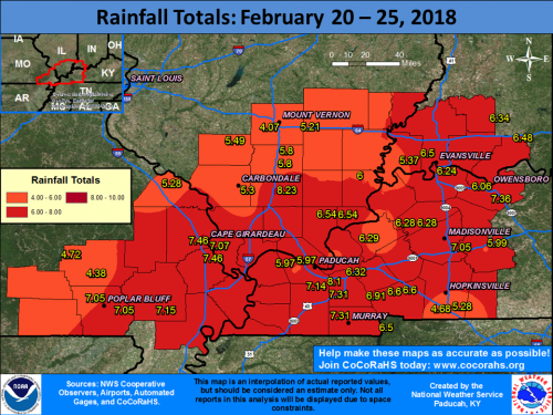
PADUCAH, KY – Multiple waves of precipitation moved through our region from the evening of February 20th through the morning of February 24th. A warm front lifted across the region on Saturday afternoon, followed by a cold front that quickly moved through during the late afternoon and evening hours. Severe thunderstorms accompanied this system with damaging winds and a few tornadoes, including two EF-2 tornadoes that occurred in the Hopkinsville, KY and Matthews, MO areas. Please note that damage surveys are still ongoing with this event! There was also widespread flooding across our area due to 5 to 8 inches of rain falling over a 4 to 5 day period. Flash flood warnings were in effect for the vast majority of the region late Saturday afternoon and evening.

Please click on the link for an interactive web page from the National Weather Service of Paducah Ky.

http://www.weather.gov/pah/2018_Feb24_EventSummary

Witthoft donations upgrade RLC’s Learning Resource Center

By ReAnne Palmer, Rend Lake College Public Information 

INA, IL – Thanks to the donation and dedication of one former Rend Lake College employee, the interior of the college’s Learning Resource Center (LRC) received a much-needed upgrade over holiday break. Andrea Witthoft, retired Vice President of Institutional Effectiveness, saw the need to improve the aesthetics and environment of the facility, and decided to help.

Witthoft, CENTER, poses before one of the updated interior walls of the LRC Tuesday afternoon. Also pictured is RLC President Terry Wilkerson, LEFT, and RLC Foundation CEO Kay Zibby-Damron, RIGHT.
(ReAnne Palmer / RLC Public Information)

Witthoft, a resident of Anna, retired from RLC in December of 2016, just before her 18th anniversary with the college. She was no stranger to higher education in Southern Illinois, having another nine years of service at Shawnee Community College. In addition to her years working on campus, in retirement Witthoft is a consistent donor to the RLC Foundation who specified a portion of her donations to improvements in the LRC.

Members of the RLC Physical Plant performed the updates during the recent holiday break so as to not disrupt students. It was completely shortly before students arrived on campus to start the Spring 2018 semester.

Terry Wilkerson, RLC President, said,” Rend Lake College and the RLC Foundation are very honored and humbled to have a supporter like Andrea Witthoft who sees the needs of the college and responds to them through personal donations. It’s particularly significant that she’s a retired employee who is continuing to be involved with the on-goings at RLC. She’s gone above and beyond to her commitment to the college, and she’s the perfect example of seeing a need, wanting to help, and making the solution a reality.”


Franklin County Sheriff’s Office Arrest Report

BENTON – Franklin County Sheriff Don Jones has reported the following incidents/arrests.  The public is reminded that all defendants are presumed innocent until proven guilty in a court of law.
2-14-18 at 8:13 pm Deputies responded to a domestic dispute in rural West Frankfort. The investigation resulted in the arrest of April D. Plemons age 36 of Benton for domestic battery.
2-16-18 at 6:26 am Deputies responded to a single vehicle crash on Park St. Road west of Hwy. Rt. 148. A 1995 Toyota Avalon driven by Courtney D. Smith age 20 of Valier was east bound when the driver lost control and ran off the roadway into a ditch. There were no injuries. The driver was ticketed for failure to reduce speed to avoid a crash.
2-17-18 at 2:59 am Deputies responded to a single vehicle traffic crash on State Hwy. Rt. 14 at Sam Pyle Bridge Road. A 2012 Chevrolet Silverado Pick-Up Truck driven by Andrew J. Reece age 21 of Mulkeytown was west bound on Rt. 14. The Pick-Up ran off the roadway on the north side, first striking a power line box, the Pick-Up continued through the yard of a residence and struck a tree on the driver’s side. The driver and sole occupant appeared to have been killed on impact. The driver was pronounced dead at the scene by Franklin County Coroner Marty Leffler. Alcohol is believed to have been a factor.
2-17-18 at 11:43 am Deputies responded to a single vehicle crash on Crocker Road at Quail north west of Sesser. A 2014 Ford driven by Emily L. Haycraft age 19 of Tamaroa was west bound on Crocker Rd. and lost control due to slick road conditions. The vehicle left the roadway on the south side and struck a tree. The driver and sole occupant received major injuries and was transported to a local hospital by Abbott E.M.S. Sesser Fire First Responders also responded and assisted at the scene.
2-18-18 at 5:12 am Deputies responded to a single vehicle crash on State Hwy. 37 ½ mile south of Rend Lake College Road. A 2007 Dodge Ram Pick-Up Truck driven by Brock E. Scoggins age 27 of Mt. Vernon was north bound on Rt. 37 and failed to negotiate a curve, traveling off the roadway on the west side, through a ditch, overturning and rolling several times. The driver was unbelted and was ejected. He was located 82.5 feet north of the Pick-Up Truck. A Deputy at the scene attempted C.P.R., however the driver was later pronounced dead at a local hospital after being transported by Abbott E.M.S. Alcohol was a factor in the crash.
2-18-18 at 6:07 pm Deputies responded to a domestic dispute at a residence in Valier. The investigation resulted in the arrest of Andrea L. Avalos age 26 of Valier for domestic battery.
2-20-18 at 1:18 pm a traffic stop in Benton resulted in the arrest of Loren J. Owens age 38 of Benton for driving while license suspended.
2-22-18 at 11:25 pm the investigation of a minor traffic crash on Park St. Road in rural Mulkeytown resulted in the arrest of Cori M. Siefert age 26 of Sesser for driving under the influence of alcohol.
2-23-18 at 8:52 am Deputies responded to the Zeigler-Royalton Grade School. A male 14 year old student had verbally threatened the safety of students and staff. The student was not armed or in possession of any type of weapon and no student was ever in danger. The juvenile was taken into custody without incident is being detained in the Franklin County Juvenile Detention Center.
WARRANT ARRESTS
2-14-18 Devin A. O’Daniel age 25 of Royalton. Failure to appear on drug charges
2-15-18 Cody J. Yard age 25 of West Frankfort. Failure to appear for resisting a peace officer
2-17-18 Ashlee N. Austill age 22 of Duquoin. Failure to appear on traffic charges
2-20-18 Jennifer M. Smith age 46 of West Frankfort. Violation of probation

Illinois State Police warns drivers to watch out for potholes

From the Illinois State Police- District 13

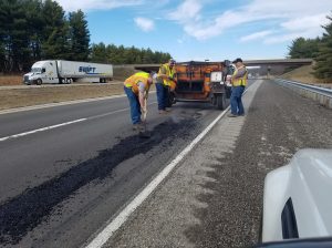
DU QUOIN – Sure! It’s beautiful out now, but yesterday’s rains left a little present for roadway users. Nasty little things, they are! They will tear up your cars, flatten your tires, and knock your front end out of alignment.

Illinois State Police photo

It’s an unfortunate consequence of water. One of the most powerful forces of nature, moving water is capable of ripping large holes in pavement like it was a Kleenex. Avoid moving the water in those puddles. It’ll tear up your car…

Increase your following distance to the car in front of you. It gives you more time to react. Look for the holes instead of at your phone. Can’t see them if you’re checking social media or texts 

Hope you enjoyed this humorous look at a common problem this time of year. #GiveEmaBrake as IDOT patches holes this time of year!

Benton, West Frankfort, Illinois News | Franklin County News