It’s coming -Freezing rain advisory until 6pm

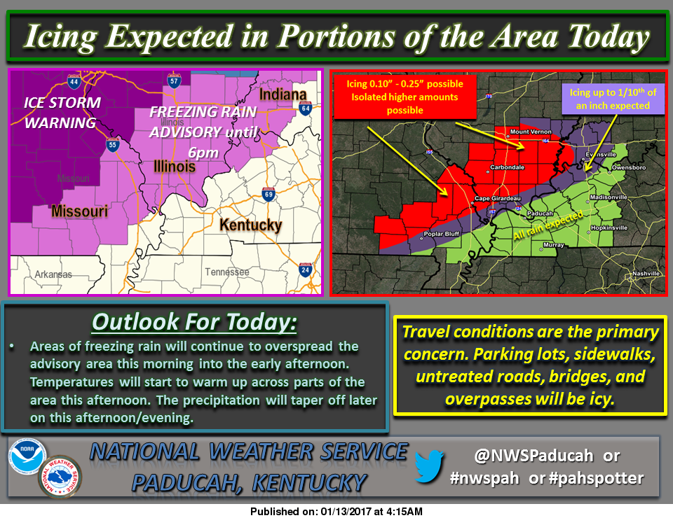
A freezing rain advisory is still in effect for Franklin County until 6:00 pm today.

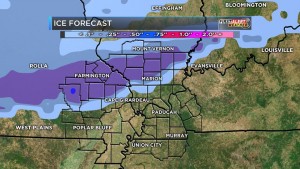
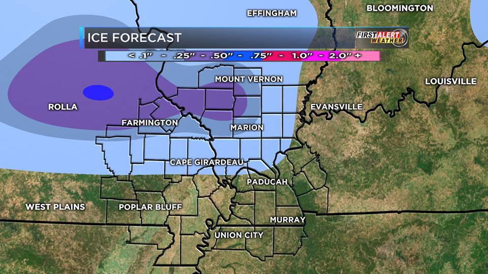
Here is a graphic for the amount of precipitation from the National Weather Service from Paducah KY:

friday the 13th weather chart #2

Here are the statements that are in effect for Franklin County from the National Weather Service in Paducah KY:

…FREEZING RAIN ADVISORY REMAINS IN EFFECT UNTIL 6 PM CST THIS EVENING… A FREEZING RAIN ADVISORY REMAINS IN EFFECT UNTIL 6 PM CST THIS EVENING. *

TIMING…THROUGH THE DAY TODAY.

* ICE ACCUMULATIONS…A GLAZE OF ONE TO TWO TENTHS OF AN INCH OF ICE LIKELY MOST AREAS. ACCUMULATIONS CLOSE TO ONE QUARTER OF AN INCH EXPECTED FROM MARBLE HILL TO JACKSON TO PERRYVILLE MISSOURI TO CARBONDALE AND PINCKNEYVILLE ILLINOIS.

* IMPACTS…TRAVEL IMPACTS EXPECTED…ESPECIALLY ON SECONDARY AND UNTREATED ROADS. SIDEWALKS AND PARKING LOTS MAY BE VERY SLICK IF NOT TREATED. VEHICLES WILL ICE OVER. SOME ICE ACCUMULATION ON POWER LINES IS EXPECTED.

PRECAUTIONARY/PREPAREDNESS ACTIONS… A FREEZING RAIN ADVISORY MEANS THAT LESS THAN ONE QUARTER INCH OF FREEZING RAIN OR FREEZING DRIZZLE WILL CAUSE HAZARDOUS TRAVEL CONDITIONS. BE PREPARED FOR SLIPPERY ROADS. SLOW DOWN AND USE CAUTION WHILE DRIVING.

THIS HAZARDOUS WEATHER OUTLOOK IS FOR PORTIONS OF SOUTHERN ILLINOIS, SOUTHWEST INDIANA, WESTERN KENTUCKY, AND SOUTHEAST MISSOURI.

.DAY ONE…TODAY AND TONIGHT A FREEZING RAIN ADVISORY IS IN EFFECT TODAY ALONG AND NORTHWEST OF A LINE FROM HENDERSON KENTUCKY TO POPLAR BLUFF MISSOURI…INCLUDING ALL OF SOUTHERN ILLINOIS UNTIL 600 PM.

ICE ACCUMULATIONS WILL BE HIGHEST FROM NORTH AND WEST OF A LINE FROM MARBLE HILL MISSOURI TO CARBONDALE ILLINOIS…WHERE UP TO ONE QUARTER INCH OF ICING IS POSSIBLE.  PLEASE REFER TO THE FREEZING RAIN ADVISORY FOR DETAILS. .

DAYS TWO THROUGH SEVEN…SATURDAY THROUGH THURSDAY SMALL CHANCES OF THUNDERSTORMS ARE POSSIBLE OVER ALL OR PART OF THE OUTLOOK AREA MONDAY THROUGH TUESDAY EVENING. NO WIDESPREAD SEVERE IS EXPECTED. LIGHTNING AND LOCALLY HEAVY DOWNPOURS WILL BE THE PRIMARY HAZARDS.

Here is a link to the seven day forecast for Franklin County

http://forecast.weather.gov/MapClick.php?map.x=176&map.y=89&site=pah&zmx=1&zmy=1#.WHjVkNQrJxA

We will keep everyone updated on road conditions and cancellations-

sd


Edwards explains reasons for ending career

Carl EdwardsNote: NASCAR driver Carl Edwards has quite the story of perseverance. His announcement to step out of the sport at the height of career rocked the racing world today. Here is an interview with him highlighting his racing career from his hometown Columbia Daily Tribune.

Monopoly Is Letting You Decide If They Should Change the Classic Tokens

monopoly-board-webIf you’ve ever wondered why there’s still a wheelbarrow token in the Monopoly board game, now’s your chance to ensure that the game pieces for the next version of the game are the ones that truly deserve to be there. From January 10 through January 31, Monopoly is asking the Internet to vote for the game pieces that they deem worthy to be the next eight tokens, ranging from current classic pieces like the thimble and top hat to more than 50 new options that include a rubber duck and a penguin. Some of the tokens that more accurately represent modern times are a wireless phone, a computer, a kissy face that bears a striking resemblance to an emoji, and a sports car. This isn’t the first time that Monopoly game pieces have been updated; in fact, the most recent update was the replacement of the iron token with Hazel the Cat in 2013. Please click to read the rest of the story from Time magazine.

Trump gives a press conference for the ages

(AP photo)

(AP photo)

President-Elect Donald Trump gave his first news conference since winning the election — and it was epic. If pundits and the Washington elite think Mr. Trump is going to change his tone or style going into the White House, they’re sorely mistaken. He’s a fighter. He’s accomplished too much in his life, overcome too many obstacles to bow down to anybody. Including the press. “No, I’m not going to give you an answer,” Mr. Trump told CNN’s Jim Acosta. “You are fake news.” The exchange came on the heels of an explosive CNN report that said the intelligence community presented a briefing to both President Obama and Mr. Trump “including allegations that Russian operatives claim to have compromising personal and financial information about Mr. Trump.” Except no one knows if that’s true — or has verified the contents of the report on which it was based. Please read the rest of the story from Kelly Ridell of the Washington Times…(This is an op-ed piece but it also gives the highlights of today)

Sports: Area legends to enter St. Louis HOF

Rich Herrin in his early days as SIU coach leads a lot of Southern Illinois legends into their induction into the St. Louis Sports Hall of Fame (Southern Illinoisan File Photo)

Rich Herrin in his early days as SIU coach leads a lot of Southern Illinois legends into their induction into the St. Louis Sports Hall of Fame (Southern Illinoisan File Photo)

The St. Louis Sports Hall of Fame will induct its first class of Illinois sports stars, several of whom have ties to Southern Illinois University, February 2. The event will take place at the Gateway Classic Car St. Louis Showroom in O’Fallon. Among the honorees are former Saluki basketball coach Rich Herrin, long-time sports information director Fred Huff and former Saluki football player Carl Mauck. The inaugural class of inductees and special award winners includes: Dave Butz, football; Gary Gaetti, baseball; Craig Hentrich, football; Rich Herrin, basketball; Marnie Triefenbach-Herrling, volleyball; Dana Howard, football; Manny Jackson, basketball; Arnie Knepper, auto racing; Carl Mauck, football; Don Ohl; basketball; Kirk Rueter, baseball; Tom Stock, track and weightlifting; and Tom Wargo, golf.

Ice for late Thursday night and into Friday.

We are sitting on the fence on this in Franklin County.  Ice is very tricky to forecast.  Forecast models are very confident there will be significant icing northwest of us.  There will be a model below by KFVS-12 meteorologist Brian Alworth posted this morning on social media.  On his page.  It is noteworthy by here in Franklin County we are in the 1/4 to 1/2 inch of ice range.  However, the Southern Seven counties are expecting mostly rain.  Honestly, I think it is wise to be prepared for the worse case scenario.

Franklin County is in the quarter to a half inch range. (KFVS-TV Photo)

Franklin County is in the quarter to a half inch range. (KFVS-TV Photo)

Here is the quote from Alworth, “We are still studying the threat of freezing rain in the Heartland early Friday. This sort of system is difficult for forecast models to handle. We are expecting a very shallow layer of cold air to blow in from the north Thursday night into Friday morning…with surface air temps across our northern counties just below freezing. Meanwhile just a few hundred feet up we’ll still have warmer air…so that precip will fall as rain and freeze on contact especially on raised surfaces.”

“Models with greater resolution (more layers in the vertical) handle this sort of scenario better…and today we’ll start to get data from these shorter-term models.”

Here is the Hazardous Weather Outlook put out by the National Weather Service of Paducah KY for Franklin County,

.DAY ONE…TODAY AND TONIGHT A FEW ISOLATED THUNDERSTORMS WILL BE POSSIBLE TODAY AND TONIGHT.

.DAYS TWO THROUGH SEVEN…THURSDAY THROUGH TUESDAY ISOLATED THUNDERSTORMS ARE POSSIBLE ON THURSDAY. FREEZING RAIN AND A GLAZE OF ICE ARE POSSIBLE ACROSS PORTIONS OF SOUTHEAST MISSOURI…SOUTHERN ILLINOIS AND SOUTHWEST INDIANA FROM LATE THURSDAY NIGHT THROUGH EARLY FRIDAY EVENING. SIGNIFICANT RAINFALL AMOUNTS COULD OCCUR SATURDAY THROUGH TUESDAY.

HOWEVER…THE EVENT WILL BE SPREAD OUT OVER SEVERAL DAYS. THIS WILL LIKELY RESULT IN STANDING WATER IN LOW LYING AND POOR DRAINAGE AREAS…ALONG WITH POSSIBLE RISES IN SMALL CREEKS AND STREAMS.

Here is a link to the seven day forecast for Franklin County

http://forecast.weather.gov/MapClick.php?map.x=176&map.y=89&site=pah&zmx=1&zmy=1#.WHZePdQrJxA

This is a situation that needs to be taken serious.  We have not had the possibility of ice in the forecast like this in several years.  I think the “bread and milk” run might be warranted over the next few days.

The B meteorologist student in two whole classes can see anything happening.  If we receive half-inch of ice, and we are not going anywhere.  Make sure you have adequate supplies to survive without power for several hours.

Franklincountynews-com will keep releasing things from media sources on the Facebook page throughout the day.  When any watches are warnings is issued, we will post as a news story.

School-business closings will be updated frequently.


Main Street in WF Closed at the tracks

Union Pacific crews working on the railroad crossing on East Main Street in West Frankfort (Jeff Webb photo)

Union Pacific crews working on the railroad crossing on East Main Street in West Frankfort (Jeff Webb photo)

Union Pacific has completed the work on the crossing on South Main (Route 37) in Benton.  It has been open to traffic since yesterday afternoon.

Main Street in West Frankfort (Route 149) is now closed for repair of the railroad crossing.  It will be completed before 7:00 p.m. tomorrow evening, weather permitting.

Ally Gischer tops 1,000 points in her Rangerette career

Steve Dunford

BENTON-  Rangerette guard Ally Gischer eclipsed the 1,000 point mark as Benton fell to a very good Herrin Lady Tiger club, 42-30 last night at Rich Herrin Gym.

Ally Gisher, along with Coach Andy Sloan after last night's win

Ally Gisher, along with Coach Andy Sloan after last night’s win

Ally Gisher said, “She was super excited to achieve the milestone. I was not a big scorer when I entered into high school, and I worked hard in improving my part of the game.”

She had this to say about Rangerette Coach Andy Sloan.  “He has the perfect balance of giving instruction, and being approachable when you need to.  I could not imagine playing for anyone else.”

Gischer led the Rangerettes with 12 points, Alexis Abney added nine on the night and Kaylee Pedigo added seven.

Hannah Grotauge led Herrin with 12 points on the night.  I think it is very noteworthy of the Rangerette defense that she was held to 12.

The Rangerettes are in action Thursday night at home in an intra -division SIRR game against DuQuoin

BOX SCORE:

BENTON (30)  Gischer 2 2 2-2 12; Abney 3 0 3-4 9; Pedigo 3 0 1-3 7; Carlton 1 0 0-0 2; Casey 0 0 0-0 0; Milby 0 0 0-0 0; Darr 0 0 0-0 0; Wilcox 0 0 0-0 0; Zinzeletta 0 0 0-0 0; Johnson 0 0 0-0 0

HERRIN (42)  Grotauge 4 0 3-6 11; Smothers 2 0 4-7 8; Mad. Russell 3 0 0-0 6; Deaton 1 0 0-0 5 Linehoff 1 0 2-2 2

SCORE BY QUARTERS: 

BENTON    7    10    7     6 – 30

HERRIN     8    13    8   13 – 42


Liueutenant Governor tours Franklin Hospital, discusses Telehealth Program

Franklin Hospital board with the Lieutenant Governor

Franklin Hospital board with the Lieutenant Governor

BENTON – Illinois Lt. Governor Evelyn Sanguinetti toured Franklin Hospital on Friday and witnessed a demonstration of a TeleHealth clinic visit provided through Southern Illinois University (SIU) School of Medicine in Springfield. “Time and again I have heard about the lack of specialty and primary care availability in rural communities,” said Lt. Governor Sanguinetti, who serves as chairman of the Governor’s Rural Affairs Council. “Residents can face 60 to 90 minute drive times to major medical facilities, and this is only if they have access to reliable transportation. Improving our TeleHealth infrastructure will address these rural health disparities and offer innovative ways to provide the quality healthcare access that all Illinoisans deserve.” Nina M. Antoniotti, Executive Director of TeleHealth and Clinical Outreach for the SIU School of Medicine, outlined the program for the Lt. Governor, saying “Illinois is way behind many other states when it comes to public policy that removes the barriers to the use of TeleHealth to improve access, improve clinical outcomes, and reduce cost to the state for health care programs serving our state’s most vulnerable populations.” Please click on the link to read the rest of the story from WMCL Radio in McLeansboro

Wind….rain….possibly a thunderstorm or two…and ice over the next few day

windy

First of all, I apologize for being so late with this.  I try to have this posted by 6:00 a.m. every morning.

I don’t think it is any surprise to anyone, but we are under a wind advisory until 6:00 p.m. tonight.  There has been spotty power outages across the county this morning as well as limbs blocking lanes of traffic on a few roadways.

Highs today will be in the 60’s as well as the rest of the week, as freezing rain will come in the forecast for Thursday night into Friday.

Below is the latest model posted by KFVS-12 meteorologist Brian Alworth about the ice potential:

ice-forecast

Here are the products issued by the NWS in Paducah that are in effect for Franklin County.

...VERY GUSTY WINDS WILL PERSIST TODAY...

…WIND ADVISORY REMAINS IN EFFECT UNTIL 6 PM CST THIS EVENING… * TIMING…GUSTY SOUTH WINDS WILL CONTINUE THROUGH THE AFTERNOON. * WINDS…SOUTH WINDS FROM 25 TO 35 MPH WILL GUST TO 40 TO 50 MPH AT TIMES. *

IMPACTS…POWER OUTAGES DUE TO LIMBS AND TREES FALLING ON POWER LINES CAN BE EXPECTED. THE WINDS WILL CAUSE TRAVEL DIFFICULTIES, ESPECIALLY TO HIGH PROFILE VEHICLES TRAVELING ON EAST-WEST ORIENTED ROADWAYS. ALSO, LOOSE OUTDOOR OBJECTS WILL GET BLOWN AROUND.

PRECAUTIONARY/PREPAREDNESS ACTIONS… A WIND ADVISORY IS ISSUED WHEN SUSTAINED WINDS ARE EXPECTED TO REACH 30 MPH OR GREATER FOR LONGER THAN ONE HOUR, OR WIND GUSTS ARE EXPECTED TO REACH 40 MPH FOR ANY DURATION.

THIS HAZARDOUS WEATHER OUTLOOK IS FOR PORTIONS OF SOUTHERN ILLINOIS, SOUTHWEST INDIANA, WESTERN KENTUCKY, AND SOUTHEAST MISSOURI

. .DAY ONE…TODAY AND TONIGHT WIND GUSTS COULD REACH 40 TO 45 MPH FROM THIS MORNING THROUGH LATE THIS AFTERNOON. .

DAYS TWO THROUGH SEVEN…WEDNESDAY THROUGH MONDAY THUNDERSTORMS WILL BE POSSIBLE FROM WEDNESDAY THROUGH THURSDAY. STRONG STORMS CANNOT BE RULED OUT THURSDAY.

FREEZING RAIN AND A GLAZE OF ICE ARE POSSIBLE ACROSS PORTIONS OF SOUTHEAST MISSOURI…SOUTHERN ILLINOIS AND SOUTHWEST INDIANA FROM LATE THURSDAY NIGHT THROUGH EARLY FRIDAY EVENING.

HEAVY RAINFALL AMOUNTS ARE FORECAST…THOUGH THE EVENT WILL BE SPREAD OUT OVER SEVERAL DAYS. THIS WILL LIKELY RESULT IN STANDING WATER IN LOW LYING AND POOR DRAINAGE AREAS…ALONG WITH RISES IN SMALL CREEKS AND STREAMS.

For updates about the unsettled weather conditions we are facing check franklincounty-news.com for continuous updates and possible cancellations throughout the week.

Here is a link to the seven day forecast for Franklin County.

http://forecast.weather.gov/MapClick.php?map.x=176&map.y=89&site=pah&zmx=1&zmy=1#.WHT3xdQrJxA


Benton, West Frankfort, Illinois News | Franklin County News